


There are no active warnings for this location.
Weather Maps
Daily Forecast
Showers & the odd thunderstorm over the northern tropics in humid, unstable air masses. Scattered showers for coastal NSW & Qld with moist onshore winds. A few showers in southwest WA in unstable air. Drier elsewhere in high pressure.
Latest Warnings
AUS

Latest News


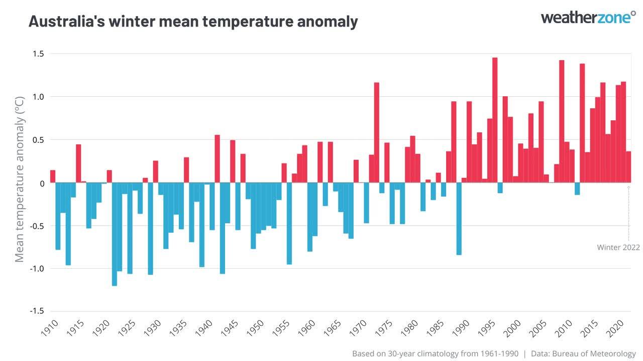
Climate Updates

Latest News

Today, 6:19AM UTC
Adelaide's driest start to the year since the 1980s
Halfway through autumn, Adelaide continues to endure an early-year dry spell the likes of which it has not seen since the famously barren decade of the 1980s. Just 14.4mm of rain has been recorded at the city’s main weather station from January 1 to the morning of April 15, 2025. That makes it the South Australian capital’s 4th-driest period on record from the start of the year to the mid-point of autumn. The only drier years from Jan 1 to April 15 were 1986 (11.4mm), 1989 (11.2mm) and 1980 (5.8mm). So Adelaide has not been this dry to start the year since 1989, which was 36 years ago. As you’d expect with so little total rainfall, Adelaide has had just seven rain days (days with measurable rain of 0.2mm or more). This is the city’s equal-lowest number of rain days to this stage of the year, matching the seven days in 1986. Reservoirs in the Mount Lofty catchment area in the Adelaide Hills are now at just 37%. This reflects not just the dry start to 2025, but the city’s long-running rainfall deficit. Image: The rainfall graph for Adelaide for the last 12 months (April is current to 9am, April 15) reveals that just one of the past 12 months has seen above-average rainfall. Indeed, rainfall was the lowest on record in the 14-month period from February 1, 2024, to March 31, 2025, in most of the Eyre, Yorke and Fleurieu Peninsulas, as well as parts of SA's Murraylands and Upper South East forecast districts. Kangaroo Island and parts of western Victoria were also in record territory for rainfall deficiencies over that 14-month period. READ MORE: The island that rain forgot Image: Rainfall deficiencies in Australia from February 1 2024 to 31 March 2025. Source: BoM. Ironically, parts of outback South Australia are now awash, as floodwaters surge towards the normally dry Kati Thanda-Lake Eyre from over the border after Queensland’s intense outback rainfall in March. READ MORE: Watch desert floodwaters gushing towards Lake Eyre In a further cruel irony for Adelaideans, parts of outback SA have seen more rain than the capital this year. Indeed, the famous opal mining town of Coober Pedy has received more than triple Adelaide’s rain to date in 2025, thanks to 47mm (across eight rain days) in March. As an additional insult, Adelaide is currently sweating through a prolonged spell of very warm weather for mid-April, which is already the city's second-hottest on record for April. Tomorrow (Wednesday, April 16) should see the fifth day in a row where maximum temps have topped 32°C – and bear in mind that Adelaide's average maximum in April is just 22.2°C. The good news is that wet weather is coming with a low pressure system towards the end of this week. We won’t see drought-breaking rain, but southern parts of SA will likely see at least a few millimetres, in what is hopefully a taste of what's to come as the winter wet season approaches.
14 Apr 2025, 11:32PM UTC
Rare Sydney Harbour surf on Good Friday
A powerful Tasman low will send damaging surf to NSW later this week, with waves expected to radiate into Sydney Harbour on Good Friday. A tropical disturbance (TD11F) currently being monitored by the Fiji Meteorological Service is located between New Caledonia and Vanuatu. This tropical low could briefly become Tropical Cyclone Tam as it tracks south towards Norfolk Island and New Zealand’s North Island in the next 24-36 hours. Come the closure of Wednesday, April 16, a fully fledged extratropical Tasman Low will be sitting to the northwest of New Zealand. Image: Forecast winds over the Tasman Sea at 4am AEST on Thursday, April 17. Powerful areas of gales wrapping around the south of the system on Wednesday and Thursday, as seen with the shades of purple in the image above, will whip up large and unruly seas across the Tasman. The image below shows wave heights reaching 10-12 metres to the west of New Zealand, approximately 1300 kilometres east-southeast of Sydney by Thursday afternoon. Image: OneFX significant wave heights at 1pm AEST on Thursday, April 17. Wave heights will increase rapidly overnight into Friday, April 18, as the swell muscles into the NSW coastline. Much of Friday will feature hazardous surf conditions, with the swell expected to peak around 4 to 4.5 metres in the afternoon, with swell periods of around 14 to 15 seconds. Slightly smaller waves are expected for NSW’s South Coast, with the brunt of the swell focused on the Mid North Coast, where significant wave heights could reach 5 metres. Image: Wave Graph on the Weatherzone App for Dee Why, NSW. Waves in Sydney Harbour? Wave heights should peak a touch below the powerful Tasman Low at the start of April, which saw wave heights of 5 to 6 metres off the coast. This swell had a swell direction from the southeast (between 130-150°), which sent some waves into northern sections of the Sydney Harbour, notably around Fairlight and Balmoral, and caused some port and ferry disruptions. The primary direction of this coming swell is forecast to be from the east-southeast, with a direction of about 110-120°. As seen in the image below, the more easterly direction of the swell is primed to slip through the various heads into the harbours and bays of central-eastern NSW. Image: An east-southeast (marked by the orange line) swell slipping between North Head and South Head into Sydney Harbour. Image: An east-southeast (marked by the orange line) swell threading the needle between Cape Banks and Cape Solander into Botany Bay. As a result, more wave energy should slip between the narrow heads protecting the harbours and bays, possibly enough to see keen wave riders catch some novelty harbour waves. Image: Author catching a harbour wave during an East Coast Low. With the weather expected to be clear and warm on Good Friday, it’s important to be aware of the latest weather warnings. Ocean beaches will be unruly with powerful surf and strong rips, but even usually sheltered harbour beaches could see surges of water and surprisingly large and powerful waves at times. With a high tide forecast around 11:30am on Friday, conditions are ideal for funnelling some of this swell into sheltered bays, harbours and ports. The outgoing tide into the afternoon could lead to some increasingly large waves around the harbour mouths as the tidal current amplifies the incoming wave energy, possibly disrupting ferry and port operations. Image: Recent erosion at Narrabeen Beach, on Sydney’s Northern Beaches. This powerful swell will also enhance coastal erosion, with beaches left in a vulnerable position by large swells generated by Tropical Cyclone Alfred and the early April Tasman Low, as seen in the image above.

14 Apr 2025, 6:09AM UTC
Lyrid meteor shower – how to see it from Australia
The Lyrid meteor shower will be visible from Australia later this month, offering stargazers an opportunity to witness one of Earth’s oldest known meteor showers. What is the Lyrid meteor shower? The Lyrid meteor shower, also known as the Lyrids, is an annual event that occurs when Earth passes through a trail of debris left by a comet called ‘comet C/1861 G1 Thatcher’. As Earth passes though the comet’s debris trail, the small particles disintegrate in our atmosphere and cause bright streaks of light in the night sky. From the perspective of someone viewing from Earth, the Lyrid meteor shower appears to originate from the constellation Lyra, which is why it is called the Lyrid meteor shower. Note though that the meteors don’t actually come from the constellation Lyra, this is simply a point of reference in the sky to help people identify the meteor shower. When does the Lyrid meteor shower occur? The Lyrids occur each year in mid-to-late April, becoming active between the 17th and 26th and reaching a peak around April 21-22. At its peak, the Lyrids typically produce around 5 to 20 meteors per hour, although some years are more active than others and can generate a higher number of meteors. How to see the Lyrid meteor shower You don’t need any special equipment to view the Lyrid meteor shower, and they can be seen safely with a naked eye. The best way to increase your chance of seeing the Lyrids is to: Find an area with clear sky away from light pollution. Make sure you give your eyes plenty of time to adjust to the darkness (about half an hour). Look at the sky above the horizon, facing towards the north or northeast. Watch for bright and fast flashes of light. According to NASA, The Lyrid meteor shower is one of the oldest known meteor showers on Earth, with sightings dating back more than 2,500 years. If you happen to miss the Lyrids, you will have another chance to see shooting stars during the Eta Aquarids meteor shower, which is active from late April to late May, reaching a peak around May 3-6.