


There are no active warnings for this location.
Weather Maps
Daily Forecast
A monsoon & tropical low fuel showers & storms over the NT's Top End & northeast WA. Low pressure over western Qld draws tropical moisture southward, producing heavy rain, showers & storms over Qld, NSW, eastern SA & Vic. Front & onshore winds bring showers to south WA & Tas.
Latest Warnings
AUS

Latest News

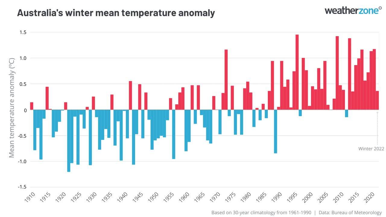
Climate Updates


Latest News

Today, 10:53PM UTC
Cyclone Dianne delivers damaging gusts to WA Kimberley
Tropical Cyclone Dianne has made landfall during the early hours of Saturday morning along Western Australia's Kimberley coast, bringing with it strong winds and heavy rain. The cyclone crossed near Cockatoo Island, just north of Derby, as a Category 1 system. The strongest wind gust of 115km/h was recorded at Koolan Island around 2:30am local time. Winds continued to gust close to 100km/h for a couple of hours before gradually easing as the system spread further inland. Tropical Cyclone Dianne's formation can be attributed to several meteorological factors that are conducive to cyclone development. Warm Ocean Temperatures: A critical factor for the genesis of tropical cyclones is sea surface temperatures of at least 26.5°C. This warmth provides the necessary heat and moisture to fuel the cyclone's development. Currently, ocean temperatures to the north of the Kimberley are sitting around 29 or 30°C. Active Monsoon Trough: The presence of an active monsoon trough can enhance the formation of tropical lows, which may intensify into cyclones under favourable conditions. In addition, this heightened activity is partly due to a monsoon surge moving from Indonesia into Australia's northern waters with a favourable phase of the Madden Julian Oscillation. As Dianne moves inland, it's expected to weaken but will still deliver significant rainfall to the region with 24-hour rainfall totals of between 50 and 250mm likely on Saturday and Sunday for central northeast WA. This will lead to flash flooding and potential isolation of some communities. In addition to the heavy rain, damaging winds are forecast with gusts up to 100km/h for inland parts of northeast WA today and 60 to 90km/h on Sunday and Monday. The remnants of Dianne will live on as the moisture and instability associated with the system spread across the NT and eventually into Qld. Heavy rain and thunderstorm activity is likely across central and eastern Qld mid-week potentially adding 80 to 100mm to the already flooding woes of communities across the State. To stay up to date with all the latest on the severe weather in the coming days check out www.weatherzone.com
Today, 5:06AM UTC
12 hours of relentless rainfall in Mackay
The city of Mackay is the latest place in Queensland to receive sustained heavy rainfall, with over 100mm falling in the 12 hours from midnight Thursday to midday Friday, as a moist onshore feed interacted with a coastal trough. The local rainfall was even heavier in the ranges to the west of the city, with 274mm recorded in the 24 hours to 9am Friday at Teemburra Dam – Mackay's main water catchment which is currently at 107.6% of capacity. Image: 12-hour radar loop showing sustained precipitation centred on the Queensland city of Mackay. A major flood warning is in place for Mackay’s Pioneer River, with minor to moderate flooding likely in Mackay itself on Friday evening as the floodwaters coincide with the high tide at 10:18pm. This has been a remarkable month of Queensland rain Many parts of Queensland experience extremely wet weather in a typical summer, but March 2025 has still been an exceptional month for Qld rainfall. Earlier this month, Brisbane had its wettest day in half a century in the wake of Tropical Cyclone Alfred. In recent weeks, Townsville has received numerous deluges, with a soggy spell that included its wettest day in 27 years. Then this week, moisture spread inland as vast parts of inland and western Queensland received a thorough soaking, with records broken at numerous locations. The map below shows Queensland's rain over the past week. Basically, it has rained everywhere, with blue and purple areas showing locations which have received 100mm or more. Image: Weekly rainfall totals for Qld from 22 March, 2025 to 28 March, 2025. Source: BoM. As for Mackay, showers – possibly heavy – will continue for the next week or so, although Queensland’s seventh-most-populous city may not see rainfall as sustained and intense as the rain that fell this Thursday and Friday.

Today, 1:11AM UTC
Kimberley on flood alert as potential tropical cyclone looms
Heavy rain is likely to cause flash flooding over parts of the Kimberley district in the far north of WA this weekend as a potential tropical cyclone crosses the coast and drags tropical moisture inland. At 8am AWST on Friday, a tropical low was located about 370 km to the north of Derby. The system could be clearly seen on satellite imagery, identified by large areas of convective cloud bubbling away to the north of the Kimberley. Image: Visible satellite images showing cloud near a developing tropical low on Friday, March 28, 2025. The tropical low is expected to move towards the south or southeast on Friday, causing it to approach the Kimberley coast and most likely make landfall somewhere between Kuri Bay and Cape Leveque on Friday night or early Saturday morning. The low is expected to gain strength before landfall, with the Bureau of Meteorology predicting it to cross the coast as a category one tropical cyclone. Regardless of whether this system makes landfall as a tropical low or tropical cyclone, it’s going to cause heavy rain and flash flooding over parts of the Kimberley from Friday night into the weekend. A severe weather warning is in place for this heavy rainfall. Image: Forecast accumulated rain on Friday and Saturday combined. Gale force winds with damaging gusts are also a good chance as the system approaches and crosses the coast, more likely if it makes landfall as a tropical cyclone. If the system does become a tropical cyclone, it will be named Dianne. Anyone in the Kimberley should keep a close eye on the latest tropical cyclone advisories and severe weather warnings in the coming days.