
Relentless rain plaguing flood-weary Queensland
March started with Tropical Cyclone Alfred soaking southeast Queensland and is ending with a major flooding event unfolding in the state’s west. So, why is Queensland seeing so much rain this month?
Rain, rain and more rain
The past few weeks have been exceptionally wet in Queensland. Even for a state that hosts the wettest town in the country and is accustomed to lengthy periods of wet weather during the monsoon season, this month has been damp.
The map below shows how much rain has been observed across Queensland during the first 26 days of March. It shows that the entire state has seen rain and areas of heavy rain have soaked the southeast, far west and north, and parts of eastern tropical coast.
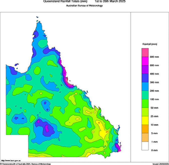
Image: Observed March rainfall as of 9am AEST on the 26th. Source: Bureau of Meteorology
Most of the highest rainfall totals on the map above can be linked to specific events that unfolded this month.
Southeast Queensland was soaked by rain from Tropical Cyclone Alfred early in the month. This slow-moving system dropped more than half a metre of rain at Coolangatta in the space of five days, with heavier totals observed in other parts of southeast Qld and northeast NSW.
Queensland’s North Tropical Coast started the month on a dry note but has seen rain falling persistently over the last 17 days. This included periods of heavy rain driven by coastal low pressure systems and troughs feeding off injections of tropical moisture.
Townsville’s running monthly total as of 9am on Thursday, March 27, had reached a whopping 941.2mm. This makes it Townsville’s wettest March on record, with data dating back to 1871. Impressively, Townsville has now amassed close to 2290 mm of rain so far this year, which is double its annual average and already its wettest year in 25 years.
This week is seeing yet another bout of widespread rain across Queensland, driven by a surge of tropical moisture associated with an active monsoon in the Australian region. While all of the state has been covered by rain-bearing clouds this week, the heaviest falls have been occurring in the west and northeast.
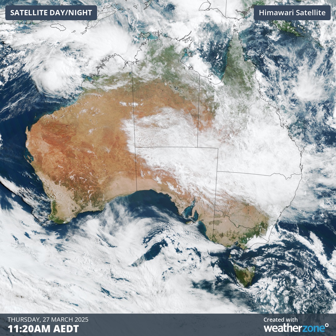
Image: Visible satellite image showing widespread cloud over eastern Australia on Thursday, March 27, 2025.
Winton is one place in western Queensland that’s already having its wettest March on record after collecting 260mm of rain in the last four days, pushing its monthly total above 290mm. In an average March, Winton would typically see about 60mm of rain.
Why has it been so wet in Queensland this month?
Queensland’s widespread rain this month has been the result of several factors combining to promote rain-bearing weather in northeastern Australia.
Monsoonal winds associated with an active Madden-Julian Oscillation (MJO) helped push moisture-laden air over Queensland in March, providing ample fuel for heavy rain. This enhanced tropical activity also helped produce Tropical Cyclone Alfred, which played a big role in the wet weather that hit southeast Qld early in the month.
A weak La Niña-like pattern in the tropical Pacific Ocean may have also helped enhance moisture over Queensland in recent weeks. While this season’s La Niña signal was only weak, similar La Niña-like patterns in the past have caused above-average rain in Qld during March, such as the 2017-18 La Niña pattern.
Above-average sea surface temperatures to the east and north of Queensland also played a role in enhancing evaporation during March. This additional atmospheric moisture provided fuel for rain.
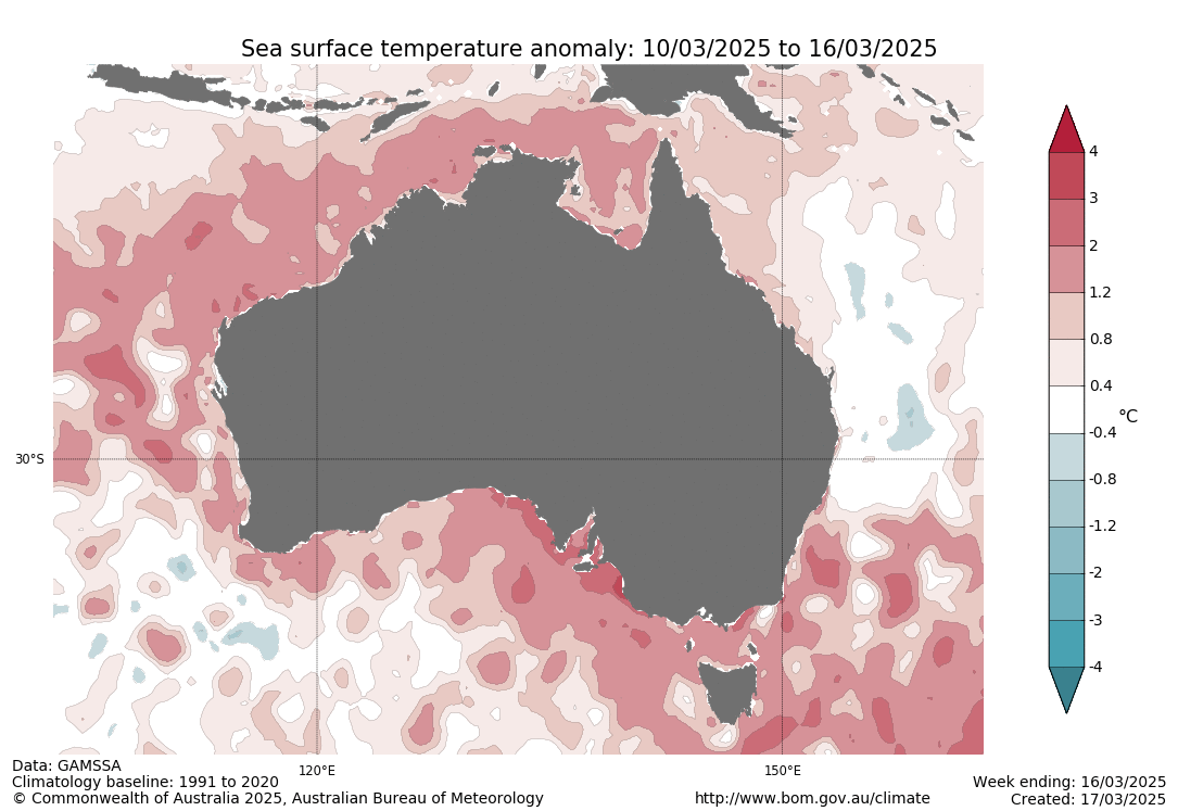
Image: Weekly sea surface temperature anomalies in mid-March. Source: Bureau of Meteorology.
Looking into the final days of March, widespread rain will continue to fall across Queensland and major flooding will linger in the state’s west. Numerous major flood warnings are currently in place, with some areas expected to experience flood peaks rivalling some of the big flood events in recent decades. There are even signs that another burst of rain will spread across the state at the beginning of April.