
Why Tropical Cyclone Alfred is about to hook a huge right turn
For the past few days, the track map for Tropical Cyclone Alfred has shown the storm steadily tracking southeast, several hundred kilometres offshore in a path roughly parallel with the Queensland coastline, before making a sharp right-hand turn towards land.
That turn will take place later this Tuesday. But why will it happen?
In simple terms, the cyclone will follow the path of least resistance. While cyclones are huge, violent weather systems in their own right, they are steered around by broad areas of high and low pressure in the atmosphere.
Since forming a week ago in the Coral Sea nearly 1000 kilometres northeast of Cairns, Tropical Cyclone Alfred has been steered steadily southwards by a ridge of high pressure to its east.
But now things are about to change. Alfred is about to come under the steering influence of a strengthening mid-level ridge of high pressure in sub-tropical latitudes south of the cyclone.
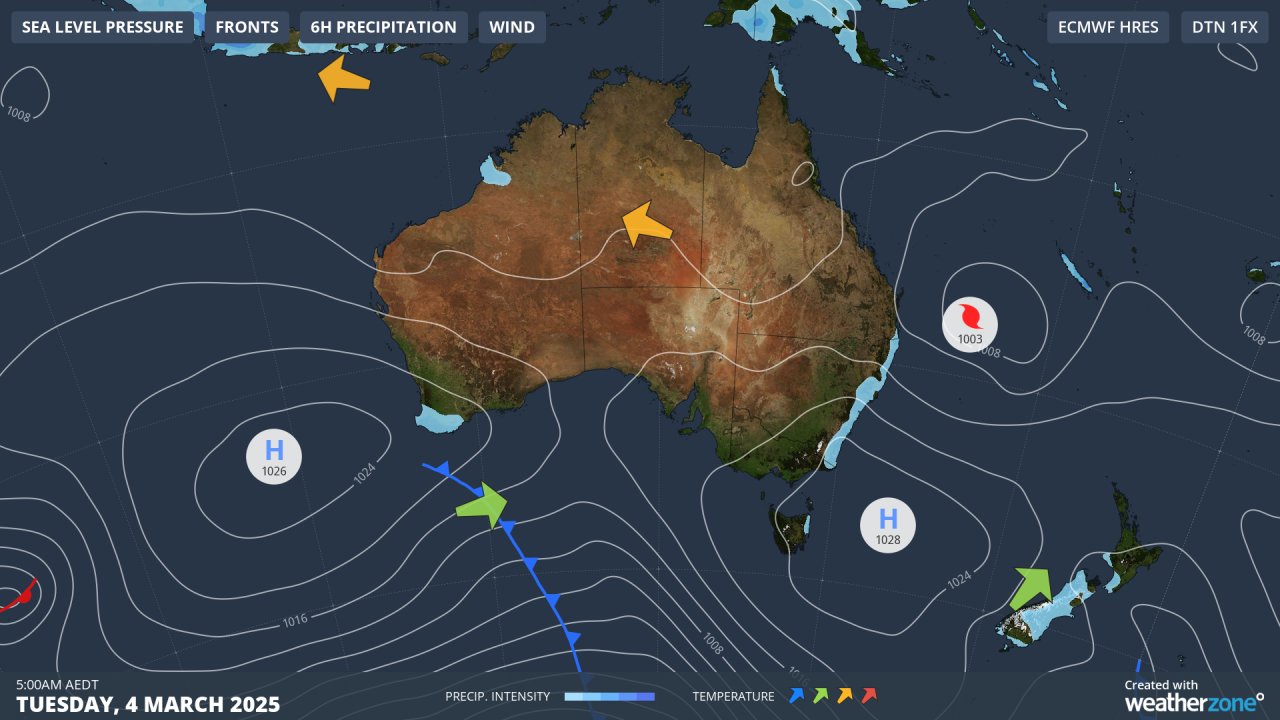
Image: Synoptic chart for Australia on Tuesday, March 4, 2025, showing high pressure at surface level.
From Tuesday afternoon onwards, winds circulating anti-clockwise around that high pressure system centred over the Tasman Sea will begin to steer Alfred west.
As it heads towards the Queensland coast where landfall is expected between the Gold Coast and Sunshine Coast sometime from late Thursday into Friday morning, it should maintain intensity due to warm areas of water near the coast.
Sea surface temperature and the passage of upper ridges and troughs are the primary drivers of tropical cyclone intensity and track. With marginal SSTs and a fluctuating upper pattern, Alfred has become a fascinating example of a hybrid tropical/subtropical system. pic.twitter.com/xiFvsfTWlA
— Andrew Miskelly (@andrewmiskelly) March 3, 2025
While tropical cyclones require ocean temperatures of at least 26.5°C to form, they can maintain cyclonic structure and intensity in slightly cooler waters with temperatures as low as 24°C or 25°C.
Alfred has been tracking southwards in waters that are in the range of 26°C to 27°C, giving it ample fuel. The cyclone briefly reached Category 4 strength east of Mackay on Saturday before downgrading to a Category 1 or 2 storm at various times in recent days.
It is current a Category 2 system and is expected to maintain that strength until it makes landfall.
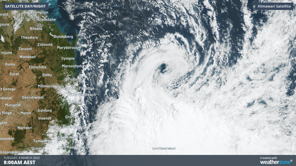
Image: Tropical Cyclone Alfred can be clearly seen rotating off the southern Qld coast in this two-hour loop on the morning of Tuesday, March 4, 2025.
According to the BoM’s tropical cyclone categories, Category 2 means:
- Destructive winds. Minor house damage. Significant damage to signs, trees and caravans.
- Heavy damage to some crops. Risk of power failure. Small craft may break moorings.
- Maximum mean wind speed 89–117 km/h.
- Typical strongest gust 125–164 km/h.
We’ll keep you updated with Tropical Cyclone Alfred’s progress throughout this week, including the extremely heavy rainfall which is likely in some areas from Thursday into the weekend.
Please also check the BoM's tropical cyclone page for the latest info.