
Why is Severe Tropical Cyclone Zelia so strong?
Western Australia’s Pilbara coast will endure ferocious winds, flooding rain and a dangerous storm surge when category five Severe Tropical Cyclone Zelia makes landfall later today. But how did a system that only became a tropical cyclone on Wednesday morning get so strong so quickly?
The two images below show Tropical Cyclone Zelia, first when it was a category 1 system on Wednesday morning, and then when it became a category 5 system on Thursday. It took a little over 24 hours for Zelia to rapidly strengthen from category 1 to a chart-topping category 5 severe tropical cyclone.
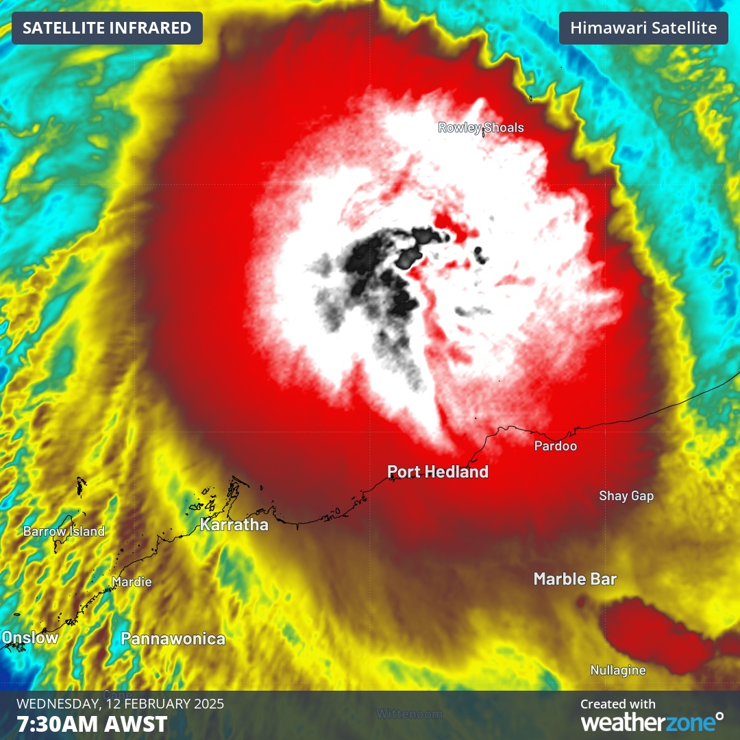
Image: Enhanced infrared satellite image showing category 1 Tropical Cyclone Zelia on Wednesday morning.
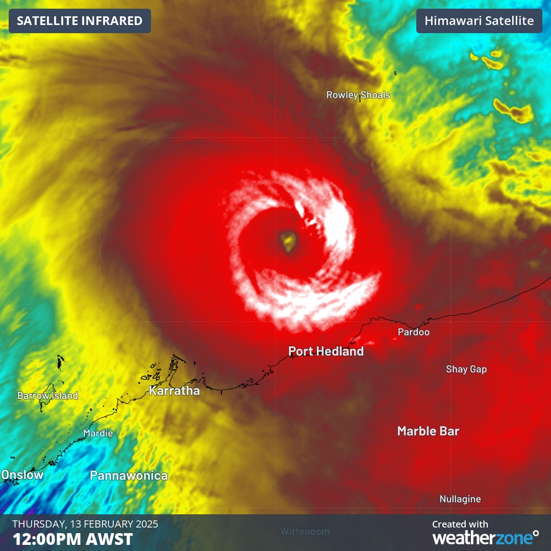
Image: Enhanced infrared satellite image showing category 5 Severe Tropical Cyclone Zelia on Thursday.
How did Zelia intensify so rapidly?
There were several factors that allowed Zelia to undergo rapid intensification over the last couple of days.
Firstly, Zelia has been drawing energy from a pool of exceptionally warm water off WA’s north coast. Tropical cyclones require water temperatures of at least 26.5°C to form. The seas beneath Zelia have been around 30 to 31°C over the past couple of days and sea surface temperatures are exceeding 32°C closer to the Pilbara coast. These are some of the warmest ocean temperatures on the planet right now. This ocean heat has provided abundant energy for Zelia to gain strength and will help it maintain its category 5 intensity as it approaches the coast on Friday.
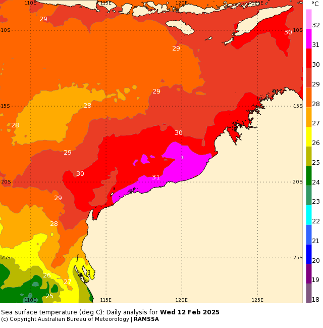
Image: Sea surface temperatures to the northwest of Australia on Wednesday. Source: Bureau of Meteorology
Secondly, Zelia has hardly moved over the past 48 hours. The competing influence of two atmospheric ridges limited Zelia’s movement between Wednesday and Friday morning. A ridge is an area of high pressure that influences the movement of tropical cyclones by steering the cyclone along the ridge's outer edges. When two ridges compete, they create opposing steering influences on a tropical cyclone. Each ridge tries to direct the cyclone along its outer flow, but if their forces are relatively balanced, the cyclone may struggle to move in any direction. This can result in a slowdown, stalling, or erratic movement.
These competing ridges allowed Zelia to hover around 140 km to the north of Port Hedland for two days, causing the system to loiter in an environment that was conducive to rapid intensification. If Zelia had been allowed to approach the coast more quickly, it may have made landfall as a weaker system.
The combination of Zelia’s slow movement, exceptionally warm sea surface temperatures and favourable atmospheric conditions caused Tropical Cyclone Zelia to undergo rapid intensification on Wednesday and Thursday.
After two days of sluggish movement, Severe Tropical Cyclone Zelia started moving towards the south-southeast in Friday morning. With this track expected to continue, Zelia will make landfall along the Pilbara coast on Friday afternoon or evening, most likely somewhere around the Port Hedland region.
Zelia will cause extremely dangerous weather as it makes landfall, including destructive winds with gusts possibly reaching around 190 km/h and flooding from heavy rain and a storm surge. While the tropical cyclone will weaken rapidly after crossing the coast, it will carry heavy rain and potentially damaging winds over inland areas of the Pilbara on Friday night into Saturday morning.