
Where will Tropical Cyclone Alfred make landfall?
Tropical Cyclone Alfred is expected to hit Australia’s east coast later this week, although landfall could occur anywhere along a 300km stretch of densely populated coastline stretching from southeast Qld to northeast NSW.
Where is Alfred now?
At 11am AEST on Tuesday, Tropical Cyclone Alfred was a category two tropical cyclone sitting about 630 km to the east of Brisbane.
The animation below shows Alfred spinning to the east of Australia on Tuesday morning. While its centre is clearly visible in these images, the bulk of its convective clouds, where most of the heavy rain is occurring, are located to the south of the system.
Video: Visible satellite images showing Tropical Cyclone Alfred to the east of Australia on Tuesday morning.
The displacement of Alfred’s convective clouds from its core is a sign that the system is battling wind shear, which means upper-level winds over the cyclone are strong enough to push its tallest clouds away from its low-level circulation centre.
Tropical cyclones don’t like wind shear because separating the low-level circulation centre from the convection typically prevents the cyclone from gaining strength.
The images above also show dry air wrapping into the centre of cyclone, highlighted by the slot of air with patches of clearer sky wrapping into the system’s core.
As a result of this wind shear and dry air entrainment, Alfred is expected to hover around category one or two strength on Tuesday and is unlikely to become a severe tropical cyclone (category three of higher).
Where will Alfred go next?
Alfred is expected to become slow-moving on Tuesday as it makes a turn towards the west. There is good agreement between forecast models that Tropical Cyclone Alfred will then move in a westward direction through the middle of this week before making landfall on Australia’s east coast on Thursday or Friday.
While there is still some uncertainty regarding Alfred’s future track and strength, there is growing confidence that Tropical Cyclone Alfred will cross the coast in southeast Qld or far northeast NSW as a category two system on Thursday night or Friday morning.
The map below shows the latest forecast track map issued by the Bureau of Meteorology shortly before 11am AEST on Tuesday.
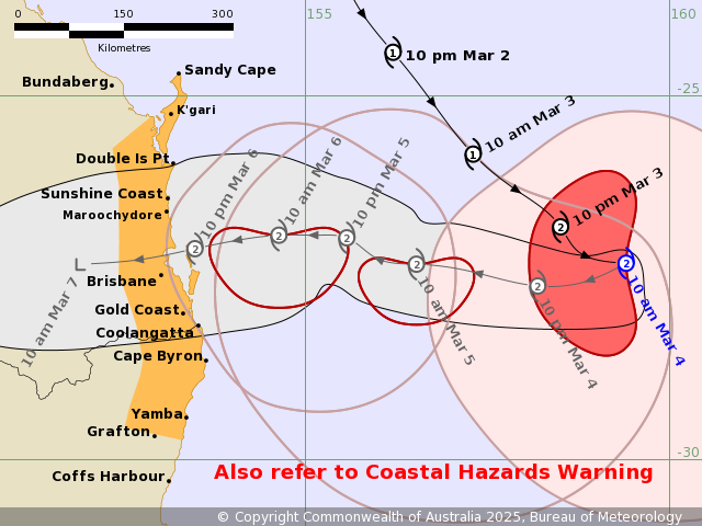
Image: Forecast track map for Tropical Cyclone Alfred, issued at 10:45am AEST on Tuesday March 4, 2025. A more recent track map may have been issued. Source: Bureau of Meteorology.
One of the most important features on the map above is the grey shaded area surrounding the forecast track. This shaded area, which extends from Alfred’s current position towards eastern Australia, is called the ‘Range of Likely Tracks of Cyclone Centre’ region. It shows that the centre of Tropical Cyclone Alfred is expected to be located somewhere inside this shaded area in the coming days, but most likely along the track that is plotted at the centre of this shaded region.
The extent of the grey shaded area on the map above shows that the centre of Tropical Cyclone Alfred is currently expected to make landfall somewhere between Double Island Point and the area just south of the Qld-NSW border. This covers about 300 km of coastline, including the Gold Coast, Brisbane and the Sunshine Coast.
It is also possible that Alfred will cross the coast outside this area, although the image above represents the most likely future track based on current computer model guidance.
Tropical cyclones are notoriously difficult to predict and their forecast tracks can change a lot from day to day. Anyone living in southeast Qld or northeast NSW should keep a close eye on the latest tropical cyclone advisories for the most up-to-date information on Alfred in the coming days.