
Where have all the isobars gone today?
A quick glance at this morning's synoptic chart shows a whole lot of not much. You might even say it's the "Seinfeld of weather charts" – the meteorological equivalent of the '90s sitcom which famously billed itself as "a show about nothing".
So why is the vast Australian continent so free of isobars and other features on the weather map today?
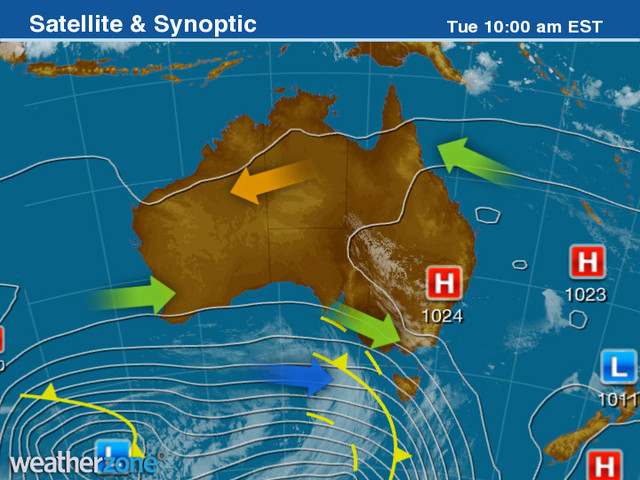
In a word, because there's very little going on over the bulk of mainland Australia on this final day of winter 2021. Or as Weatherzone meteorologist Ben Domensino explains in slightly more technical terms:
"The easiest way to explain it is that there's a weak pressure gradient across Australia today.
"Isobars [the lines on a synoptic chart] show areas of equal air pressure near the surface. When they're closely packed together, it means the air pressure changes a lot over a short distance. So for example, right now there's a strong pressure gradient across the Southern Ocean.
"But from the west coast to the east coast of Australia today, mean sea level pressure (or air pressure near the ground) isn't changing much across the country. That's what we refer to as a weak pressure gradient and that's why the isboars are virtually non-existent or spaced widely apart."
So why is the synoptic chart usually a lot busier to the eye?
"We actually see this sort of chart a lot at this time of year," Ben explains.
"Weather systems migrate from north to south (and back again) throughout the year, so in the middle of winter we'd typically see all those isobars over the Southern Ocean further north, and in summer, they'd be even further south and we'd start to see the monsoon trough affecting northern Australia.
"But in in the transition seasons of autumn and spring, we start to see charts that look like this."
Charts like this mean that there is not a lot of weather happening apart from benign, sunny windless days that we urge you to get outside and enjoy if you can – Covid lockdown rules permitting and all that.
But there are one or two spots in Australia where there's some weather about today
- There will be rain across most of Tasmania today, and indeed it's already falling in western and northern parts of the state.
- There are light scattered showers about SW Western Australia (a much stronger system will move through on Wednesday into Thursday).
- And rain continues on Queensland's central and NE coast with a moist onshore flow, which we told you about yesterday. The risk of flooding appears minor at this stage, but it's worth keeping an eye on warnings.
YOUR VIEW: Is weather more or less important to you during Covid lockdown?