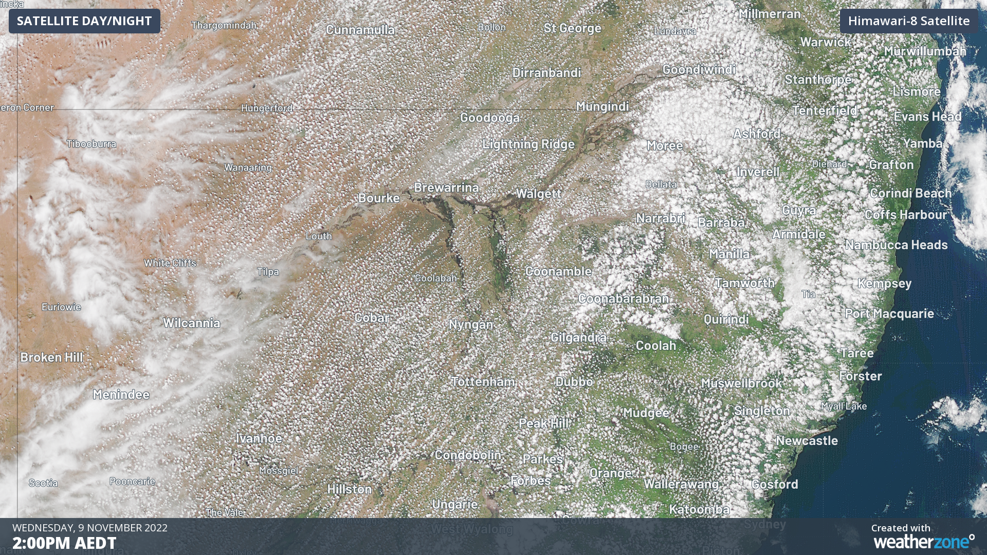
What's with these thousands of tiny cloud dots?
The cloud pattern over eastern Australia on Wednesday afternoon was highly unusual to say the least. And when viewed from a satellite, you'd have to say it was pretty spectacular.
We're talking about all those tiny dot-like clouds that formed as the day warmed in the late morning and early afternoon. It looked like thousands of spots of white, as seen from above.

As seen from below, they would have been fluffy cumulus clouds. Basically your typical "cotton wool ball" cloud.
So what made so many small clouds form so quickly?
This is where things get interesting.
For clouds to form, you need heat and moisture. As the day warmed, thermal air currents helped to lift the air at the surface. When that rising air cools, it formed clouds.
But yesterday's airborne water vapour had an unusual source: the land itself.
Normally, this part of the country would have a pretty dry land surface. But so much rain has fallen across such a wide area in recent months that the land is supporting exceptional amounts of lush, green vegetation right now.
That essentially makes great fuel for clouds (under the right conditions) through a process known as "evapotranspiration". It's basically the same process by which vast rainforests like the Amazon effectively produce their own rain.
How did the clouds stay away from the rivers?
For the record, the main river near the top of the image below (and in the GIF higher up this story) is the Barwon – a major tributary of the Darling. You can see gaps in the pattern of clouds above the river and its tributaries like the Namoi River.
That's because the air temperature is much lower over the rivers because of the cool river water, whch effectively stopped clouds forming. It's as simple as that.

What about the lines of clouds?
There's actually a name for the type of formations visible yesterday: clouds streets.
No, not the novel Cloudstreet by Tim Winton. We're talking about a unique type of cloud formation which Weatherzone meteorologist Ben Domensino wrote about earlier this year.
In the steady, largely stable northeasterly airstream that prevailed across central NSW yesterday, all those little cloud dots were basically ordered into neat parallel lines, called cloud streets.
There's a bit of cloud street activity continuing today in NE NSW, but a stronger more unstable system is moving in from the west and the weather is turning more chaotic, with storms starting to spread eastweards, some of them severe.