What's going on with Ex-Tropical Cyclone Ellie?
Image: There she blows. Cloud swirling into Ex-TC Ellie over the Kimberley.
Tropical Cyclone Ellie was a brief-lived cyclone but there is nothing brief about the low she became. After strengthening to a category 1 cyclone (the lowest category of cyclone classification) that lasted only a few hours, Ellie crossed the western Top End coast south of the Daly River mouth early in the morning of December 23rd and became a tropical low. Since then, she has wheeled east to the Queensland/NT border and back to the Kimberley, all the while triggering storms and dropping intense amounts of rain.
The swirling mass of cloud that is Ex-TC Ellie has been visible on satellite imagery for well over a week now and is currently sitting over the Kimberley. Many areas have seen over 100mm of rain multiple days in a row, including at Fossil Downs east of Fitzroy Crossing which recorded 104mm to 9am on New Year's Day and 179mm to 9am this morning. Fitzroy Crossing itself, on the main road through the area, recorded 78mm and 119mm on these days.
North of the circulation, the western Top End, including Darwin, has been copping a run of monsoon days, with many suburbs picking up more than 50mm per day for the 4 days up to and including Saturday 30th. Northwest monsoon wind gusts of over 80km/h were recorded on Friday and Saturday, including 96km/h at Darwin Harbour on Friday afternoon. Conditions over the Top End are gradually easing as the low that is Ex-Ellie moves slowly away southwestward over the Kimberley.
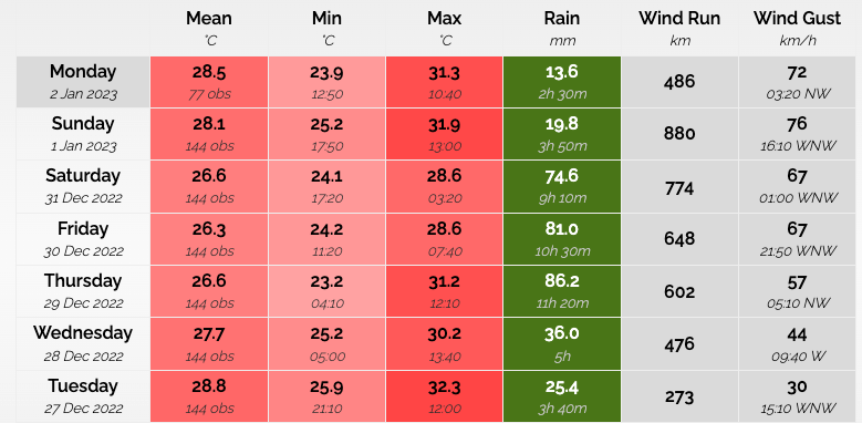
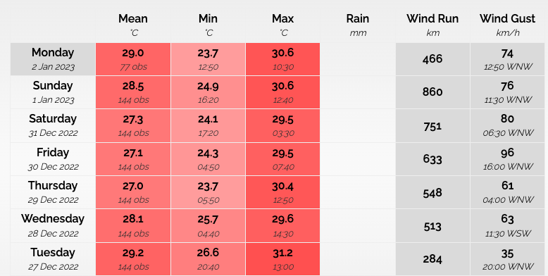
Image: Temperature, rain and maximum wind gust observations for the last week for Darwin (airport at top, Darwin harbour at bottom).
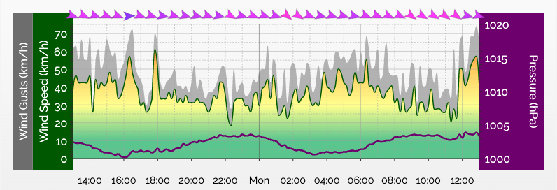
Image: Wind (direction, mean and gusts) for Darwin Harbour Sunday afternoon to today (Monday) showing northwesterly wind gusts exceeding 70km/h in the afternoons.
What happens now?
Firstly, rainfall will continue as truly huge amounts of moisture continue to feed the low. Between Tuesday night and Friday, there is a moderate chance that a tropical cyclone will redevelop from this system (which may or may not be named Ellie) and track slowly along the Kimberley and Pilbara coast. From late in the week, this low then marches south once more, with most models taking it southeastward, pushing heat towards southeastern cities next weekend.
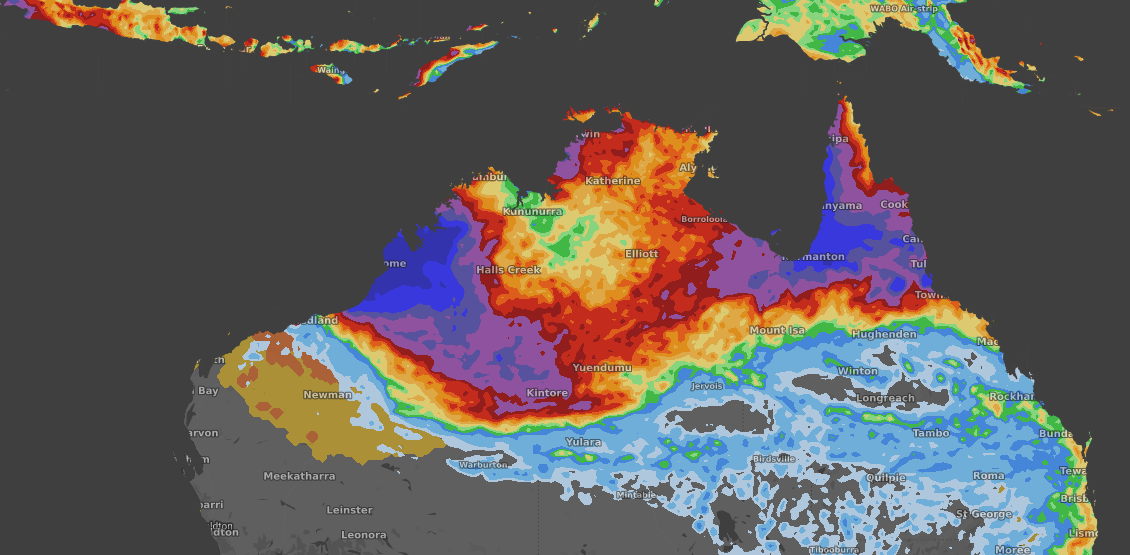
Accumulated tropical rainfall between Sunday 1st night and Friday 6th night, according to EC.
Secondly, the low is helping maintain a very strong pressure gradient across WA. Strong pressure gradients drive strong winds, and western WA is hence to be buffeted by strong easterlies. Strong easterlies that are not only hot due to coming from over the interior of the country but also because the massive amounts of energy that have flowed into Ex-TC Ellie over the last 10 days have to end up somewhere, in this case as heat to the south.
Geraldton will reach near or above 40°C Tuesday to Thursday. Perth heat will last longer, the city forecasting above 35°C Tuesday to Friday.
Easterly winds will peak in the mornings, likely gusting over 80km/h about the escarpment east of Perth and up to 70km/h over Geraldton. Over the far north, wind gusts exceeding 80km/h are also likely, with specific strengths of course dependent on low development. The most likely areas to be affected over the next 48 hours are between Wyndham and Broome.
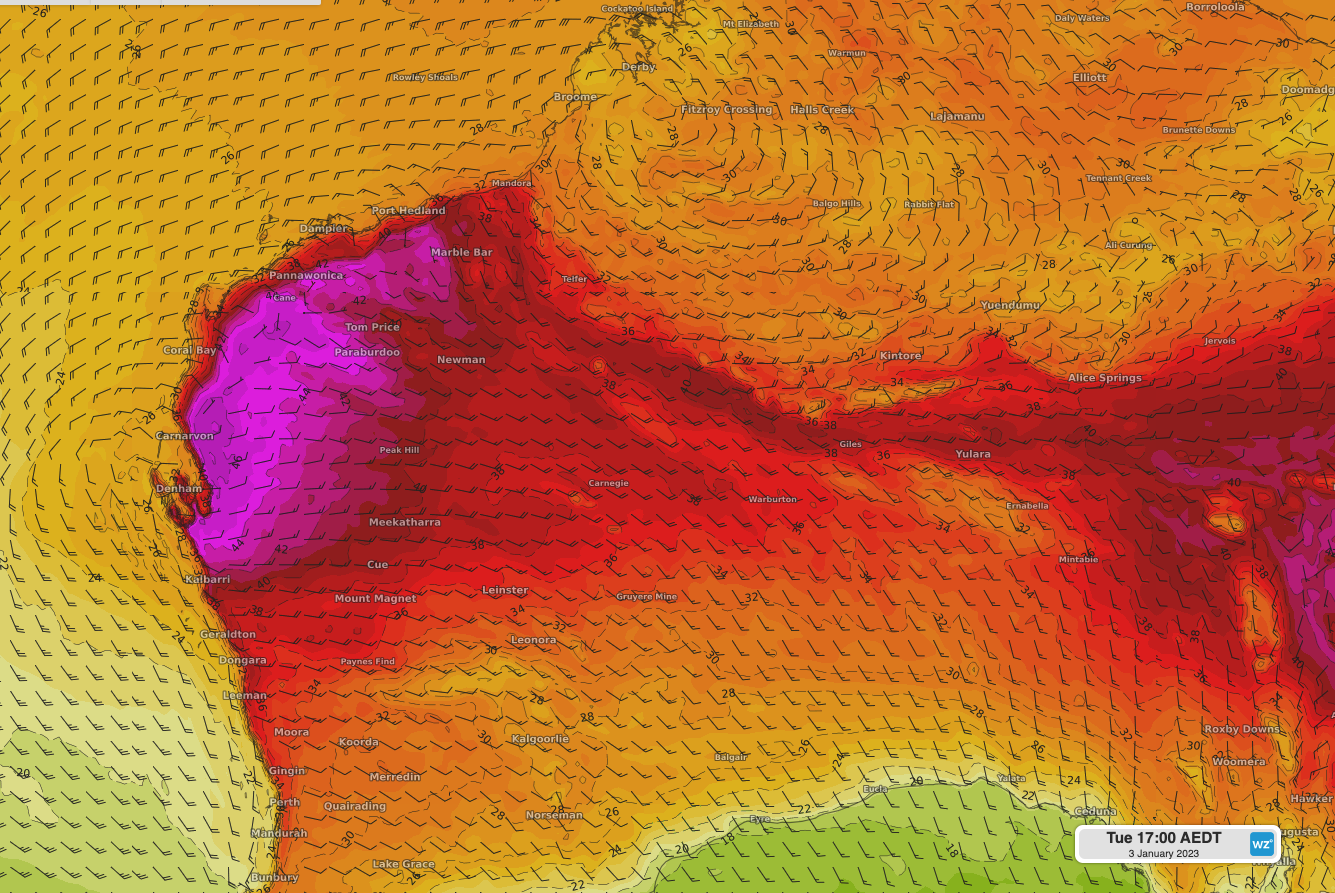
Image: Temperature and hot easterly winds (wind direction is the pointy end of the barb; so, in this case, towards the east) for Tuesday January 3rd according to the EC model.
With another rainfall-focusing low slated to form near the Gulf of Carpentaria from mid-week, it's looking like another active week for the tropics.