
What is going on with the El Nino Southern Oscillation?
The El Nino Southern Oscillation (ENSO) is currently neutral but has been swinging back and forth within the neutral range. During May it looked like La Nina might emerge during winter, earlier than our forecast for spring, but this development stalled in June, only to begin again in July.
You can see how this has unfolded by looking at the equatorial Pacific Ocean in the following animation of weekly Sea Surface Temperature (SST) anomalies with the cooler water spreading westward during May, waning during June and then reappearing during July.
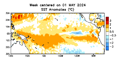
Animation: Weekly SST Anomalies from 1st May to 17 July 2024. Source: NOAA. For a higher resolution animation of daily SST anomalies see here.
This has been due to variations in the trade winds across the Pacific. Stronger trade winds (more easterly) help the cold water under the surface to upwell and spread westward (as in May and July), while weaker trade winds or westerly wind bursts cause the opposite to occur (as in June).
The cold subsurface water that we saw earlier in the year still lies beneath the eastern Pacific, but it will need consistently stronger trade winds to cause it to upwell and then spread towards the western Pacific before a La Nina can possibly get going. Otherwise, neutral conditions will persist.
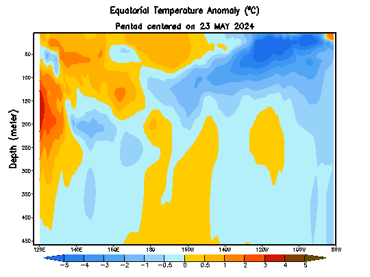
Animation: Subsurface temperature anomalies from 23 May 2024 to 22 July 2024. Source: NOAA Climate Prediction Center.
The question is whether the trade winds over the Pacific Ocean will become consistently stronger or not. In the near term, the trade winds will continue to vary, stronger than normal during the next few days but then weaker for a week or two with a westerly wind burst. However, further ahead, there are still signs of La Nina possibly developing in the Southern Hemisphere’s spring and summer.
The Bureau of Meteorology samples seven global models and presents their forecasts for the Nino 3.4 region (around the central equatorial Pacific). In terms of the SST anomaly threshold for La Nina conditions, the BOM requires -0.8 degrees Celsius below normal.
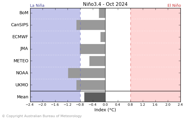
Image: Long-range model comparison of the Nino 3.4 SST anomaly for October 2024. Source: BOM
Looking at the month of October, the Australian (BOM), European (ECMWF) and French (METEO) models are forecasting neutral conditions to persist, whereas the Canadian (CanSIPS), American (NOAA), Japanese (JMA) and British (UKMO) models are forecasting La Nina conditions.
The International Research Institute for Climate and Society also creates a comprehensive comparison of global models and then builds a probabilistic forecast. Note that the threshold used by the IRI (like that used by the US NOAA) is -0.5 degrees Celsius rather than -0.8 degrees used by the BOM.
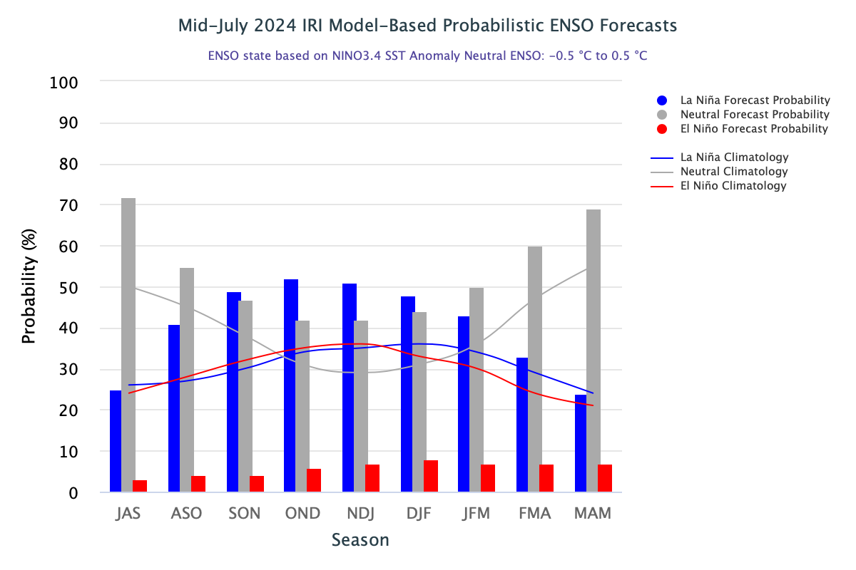
Image: IRI ENSO probabilistic forecast for Nino 3.4 region. Source: IRI
The overall picture we get from the models is that neutral or La Nina conditions are expected in the second half of the year. With the -0.5 degree threshold, La Nina is more likely but with the -0.8 degrees threshold used by the BOM, neutral conditions would be slightly more likely.
It is worth highlighting that the American (NOAA) forecast is most in favour of the development of a La Nina (as seen in the BOM comparison above), which is a forecast that is not just a straight model forecast. NOAA has human forecasters analyse their model and then adjust the forecast based on experience and historic observations. The NOAA CPC probabilistic forecast shows a much greater chance of La Nina than neutral conditions for spring and summer compared to the model probabilistic forecast of the IRI.
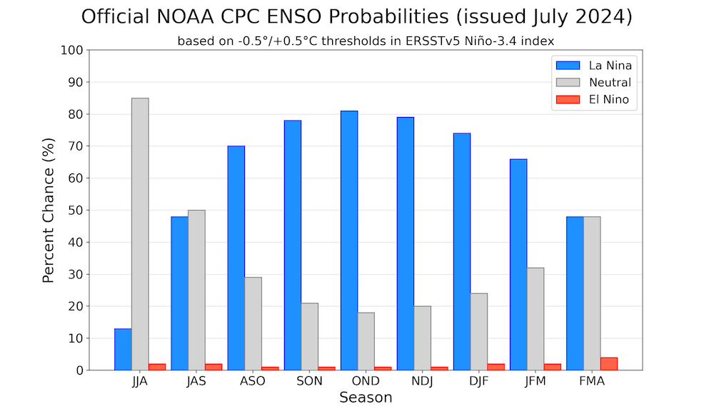
Image: NOAA Climate Prediction Center (CPC) probabilistic forecast for the Nino 3.4 region. Source: NOAA CPC, IRI
Something else worth highlighting is that the European model forecast has become more neutral than its previous forecasts which were closer to La Nina. This is interesting as we are past the autumn predictability barrier when models are expected to be less uncertain than they are before the southern hemisphere autumn.
A question worth asking is whether the latest run of the ECMWF model has incorporated a warm bias based on the warming that occurred during June. It is worth noting that something like this has happened before with this high-quality model. The year 2020 was the start of three years of La Nina. The forecast from the ECMWF model in July 2020 was much warmer compared to what was observed.
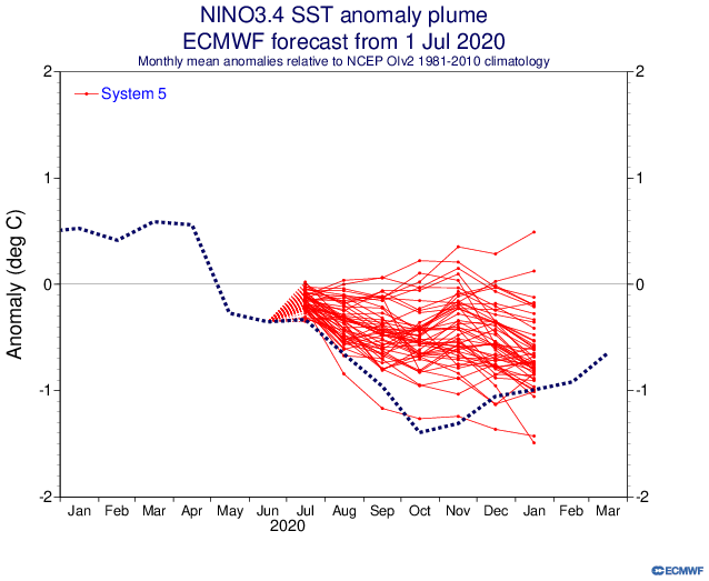
Image: ECMWF ENSO ensemble forecast (red lines are ensemble members) for Nino 3.4 region from 1 July 2020 compared to observations (dotted line). Source: ECMWF
So perhaps the US forecasters at NOAA are onto something based on their department’s deep experience. The ENSO forecast is important to NOAA at this time of the year because La Nina conditions tend to increase the impacts of the North Atlantic Hurricane season.
Stay up to date with Weatherzone’s Climate Outlook page.