
What a warm and dry winter might mean

The Bureau of Meteorology is predicting a warmer and drier than average winter across much of Australia this year.
Let's take a look at what that might mean for you.
Starting with temperatures, both days and nights are predicted to be warmer than the long-term average across most of the country during winter, with the exception of a few areas in the far north.
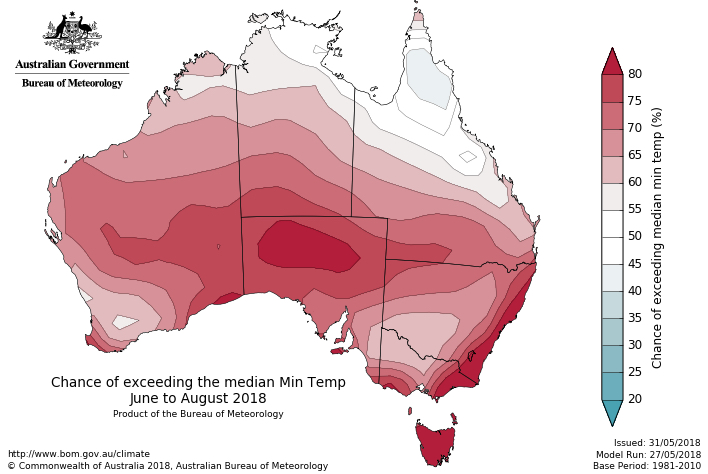
Image: Chance of exceeding the median minimum and maximum temperatures during winter. Source: BoM
This prediction of a warmer than usual season comes after some recent fanfare about the prospect of a historically cold winter in Australia, which appears unlikely given the sentiment of the Bureau's outlook issued today.
Now before you go selling your coat and Ugg Boots, it's worth pointing out that a warmer than average winter doesn't mean that it won't be cold.
A seasonal outlook refers to maximum and minimum temperatures averaged out across the entire season. Even if days and nights are warmer than usual on balance during winter, there will still be periods of bitterly cold weather, blustery winds, rain, hail and snow.
On the topic of snow, many alpine aficionados may be wondering what the latest winter outlook means for the upcoming ski season. Junt how much snow will fall this year and when should you head to the alps?
The amount of snow that falls in any given season depends on how much moisture is available in the atmosphere when it gets cold enough for snow to fall in the alps.
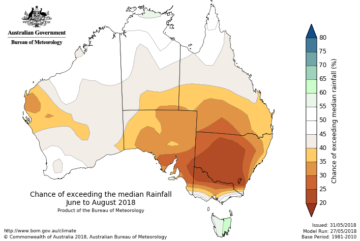
Image: Chance of exceeding the median rainfall during winter. Source: BoM
The Bureau's winter outlook shows a strong signal for below average rainfall across the southeast mainland of Australia between June and August. This, in conjunction with the anticipated above average temperatures, means the snow base could take longer than usual to build up this year.
Predicting the peak snow depth is notoriously difficult, as it only takes a few strong and well-times cold fronts to make a good season, which can still happen in a relatively warm and dry year. The average peak snow depth in Australia occurs in late August or early September, although it can vary quite a lot. Two years ago it happened in October.
Outside the alps, the prospect of a drier than usual winter across the broader area of southeastern Australia is like salt in the wounds for those living throughout the Murray-Darling Basin.
Australia's southern mailand just had one of its driest autumns on record. This follows a summer in which the Murray-Darling Basin received less than 30 per cent of its average rainfall, after its driest September on record.
The amount of accessible water across the Murray-Darling Basin has declined fairly steadily since late last year and reached its lowest level since July 2016 earlier this month. The Basin's storages are now collectively sitting at around 50 per cent full.
You can access the Bureau's winter outlook here: http://www.bom.gov.au/climate/outlooks/#/overview/summary