
Wettest and warmest recorded winter in Western Australia
While broad swathes of the interior are sweltering in record-breaking August heat, the western portion of the country has seen some winter records for both warmth and precipitation.
Across various locations, multiple records are set to be broken, both for the season and month, for both temperature and rainfall:
- Perth Airport looks to experience its warmest winter temperature average of just over 15ºC in its 80 years of records, about 1.6ºC above the long-term average
- The site also experienced the most winter rain days (58) since 1996, and most August rain days (22) since 1977
- The site also experienced the most winter rain days (58) since 1996, and most August rain days (22) since 1977
- Bunbury looks to experience its warmest winter average overall (14.1ºC) and minimum (9.9ºC) in 29 years of records.
- The site also experienced its most August rain days (25) since 1996, while more than doubling the monthly average (237.8mm, average of 118.6mm)
- Kalgoorlie looks to experience its warmest winter average minimum (7.61ºC), about 1.5ºC above the long-term average, in records back to 1939.
- The site also experienced its highest winter rainfall (133.6mm, average of 73.1mm) since 1992.
- Albany Airport looks to experience its warmest winter average maximum (17.9ºC), minimum (8.8ºC) and overall (13.4ºC) temperatures in 12 years of records.
- Geraldton Airport looks to experience its warmest winter temperature average minimum (11.2ºC, about 1.7ºC above the long-term average) in 13 years of records
- The site also experienced its highest winter rainfall (386.8mm, average of 209.5mm) in 13 years of records
Multiple instances of record minimum temperatures have been observed. Elevated moisture content keeps dewpoints higher, which in turn reduces the rate at which temperatures can drop overnight. Since temperature cannot fall below the dewpoint, higher dewpoints often result in warmer minimum temperatures. The moisture traps heat near the surface, acting as a blanket that prevents temperatures from falling as low as they otherwise might. This is largely explained by high specific humidity, as we saw in July, seen as the large purple blob in the figure below.
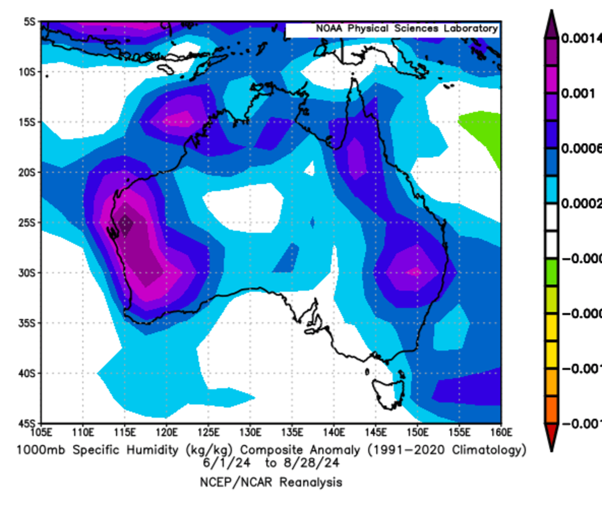
Figure: 1000mb Specific humidity anomalies (kg/kg) for winter 2024 compared to 1991-2020 climatology (NOAA Physical Science Laboratory). Western Australia has a clear positive anomaly.
In the south, more than half of the winter season was influenced by a negative Southern Annular Mode (SAM), which helped steer cold fronts across the southwest. This was evident throughout August, as a significant line of thunderstorms, the wettest weekend in decades and numerous wet spells influenced the region. The below plot shows the surface precipitation rate anomalies over the winter period. The west coast had anomalies of up to 1-2mm above the 1991-2020 climatology.
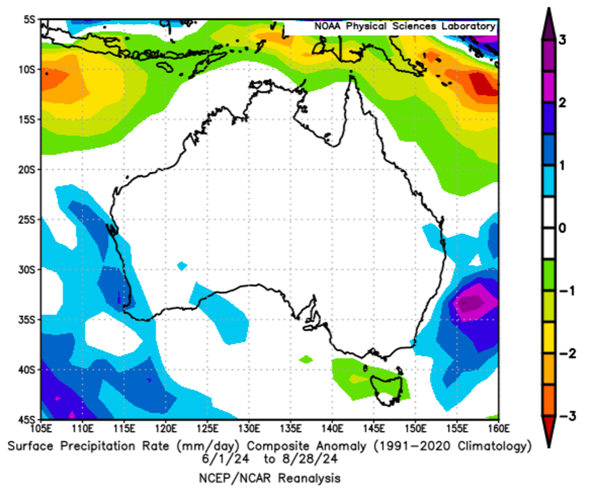
Figure: Surface precipitation rate anomalies (mm/day) for winter 2024 compared to the 1991-2020 climatology (NOAA Physical Sciences Laboratory). Much of Western Australia's Gascoyne, Central West, Lower West and South West coasts have positive anomalies.
After seeing the highest winter temperature on record and consecutive record-breaking hot days earlier in the month, it comes as no surprise that parts of the north are set to experience their second highest August average temperatures on record:
- Broome, in the Pilbara region, averaged 25.0ºC (2.5ºC above long-term average) in records dating back to 1939.
- Kalumburu, in the Kimberley region, averaged 26.2ºC (1.8ºC above long-term average) in records dating back to 1999.
Broadly speaking, this warmth can be seen in the below plot, which shows the temperature anomalies of the upper-level airmass. Virtually all of Western Australia experienced a positive temperature anomaly for winter, meaning the average was above the 1991-2020 climatology.
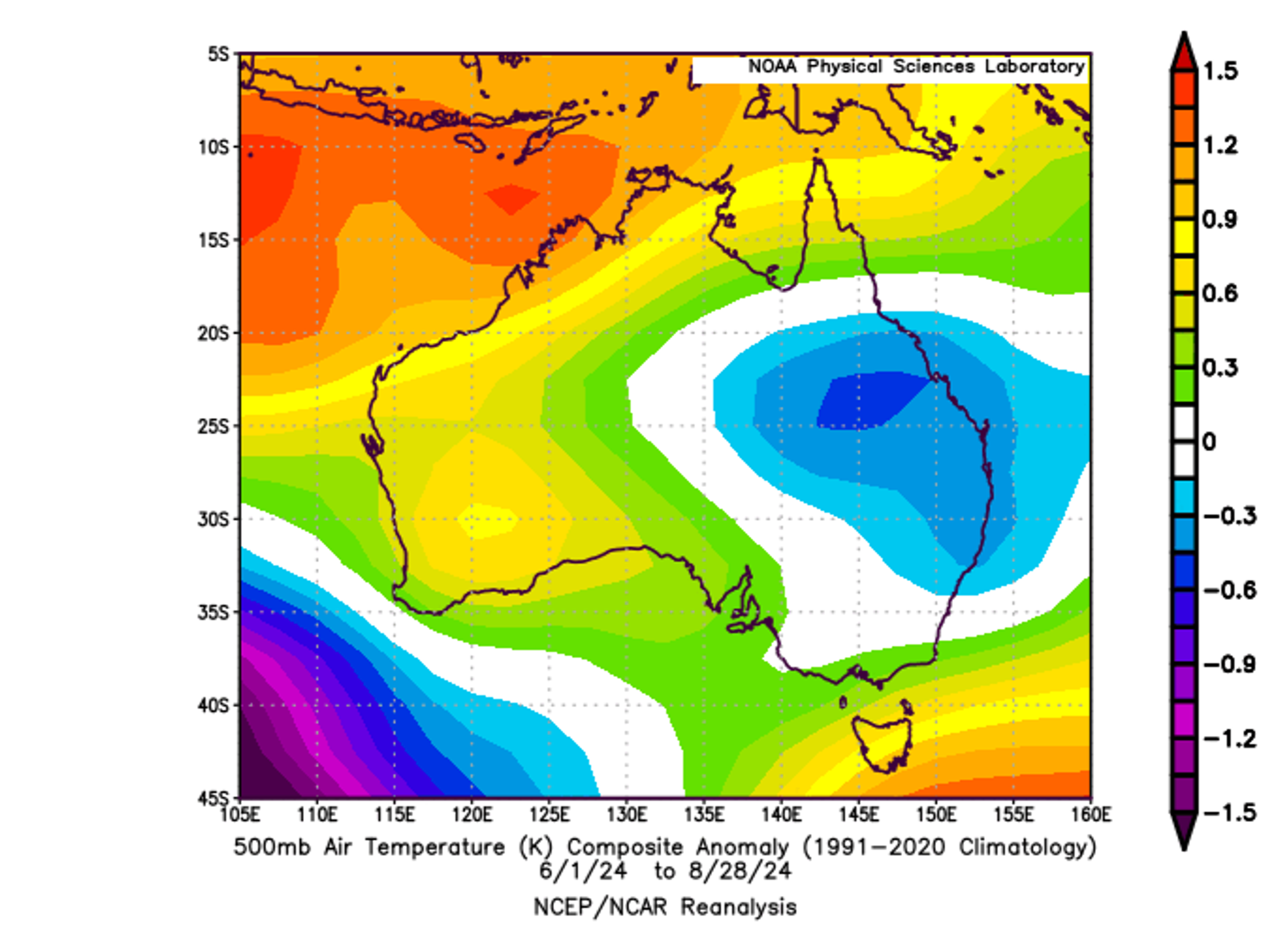
Figure: 500mb air temperature anomalies (ºK) for winter 2024 compared to the 1991-2020 climatology (NOAA Physical Sciences Laboratory). All of Western Australia has a positive anomaly.
The start of September, and hence the start of meteorological spring, looks to trend warmer than average, including for Perth. Be sure to check our website for the latest forecasts and warnings.