Wet week for Tas and southwest WA
Several cold fronts will batter southern parts of Australia this week, bringing much needed rain to areas that have seen record low rainfall this year.
During the last year, stubborn high pressure systems sitting over southern Australia have forced cold fronts and rain bearing systems south.
This led to parts of South Australia, Tasmania and southwestern parts of Western Australia seeing the lowest rain on record in the 12-months leading up to July 31, 2024
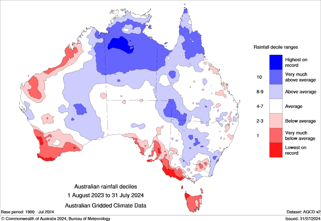
Image: Australian rain deciles between August 1, 2023, and July 31, 2024. Source: BOM
This stagnant pattern has changed in recent weeks, with frequent cold fronts passing across the south of the country.
This is in response to the Southern Annular Mode swinging into a negative phase, which increases rainfall and wind over southern Australia during winter.

During the next week, frequent rain should fall over parts of western Tas and southwestern WA. Unfortunately, SA will miss out on the larger totals, with the cold fronts slipping further south.
The map below shows that widespread falls of 30 to 60mm are forecast this week in these regions, with isolated totals of 60 to 80mm. Some of this rain will fall as snow on the Tas alps late Thursday into Friday, as a cold airmass moves over the state.

Image: Accumulated rain in the week leading up to 10pm Sunday, August 11, according to ECMWF.
While this is decent weekly rain it is not enough to replenish the severe rainfall deficiencies these regions have seen over the last year.
Looking ahead, above average rainfall is forecast for these regions in August and possibly into September with the SAM forecast to remain negative.