Vast arc of heat to sear Australia’s interior for a week
A huge band of heat has entrenched itself across the centre of Australia and it’s not going anywhere soon.
For at least the next week, parts of Western Australia, Queensland, the Northern Territory, South Australia and New South Wales will all bake in relentless furnace-like conditions.
Temperatures will likely fall a degree or two short of record-breaking status in most areas, but this event will still be remarkable for the duration of extreme temperatures.
For example:
- Birdsville (southwest QLD) has already reached 46.5°C this Wednesday, with maximum temperatures expected to reach 45°C, 43°C, 43°C, 45°C, 45°C and 45°C over the next six days.
- Alice Springs (southern NT) has already reached 42.9°C this Wednesday, with maximum temperatures expected to reach 44°C, 42°C, 42°C, 42°C, 43°C and 43°C over the next six days.
- Bourke (northwest NSW) has already reached 44.8°C this Wednesday, with maximum temperatures expected to reach 41°C, 37°C, 39°C, 42°C, 43°C and 44°C over the next six days.
- Warburton (eastern WA near the SA/NT border) has already reached 44.0°C this Wednesday, with maximum temperatures expected to reach 45°C, 45°C, 45°C, 46°C, 42°C and 40°C over the next six days.
- Moomba (northeast SA) has already reached 42.7°C this Wednesday, with maximum temperatures expected to reach 41°C, 39°C, 39°C, 43°C, 45°C and 44°C over the next six days
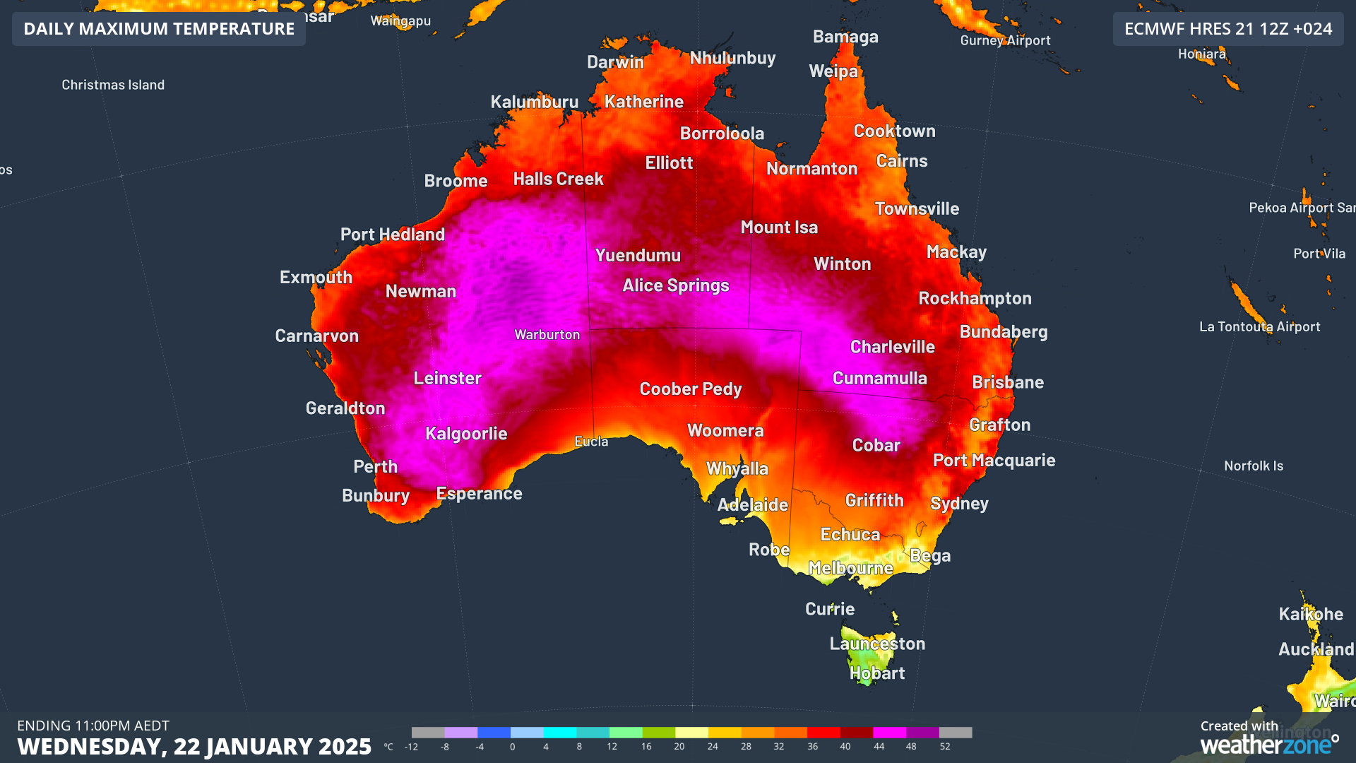
The image below shows the expected maximums this Wednesday, January 22, according to the ECMWF model.

Image: Areas of pink represent maximums of 44°C or higher.
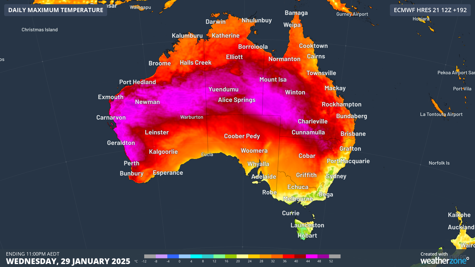
And the next image shows expected maximums next Wednesday, January 29, according to the same model. As you can see the pattern hasn’t changed too much.

Image: The heat will again spread to the central WA coast, where this week Geraldton equalled its record of 49.3°C, although temperatures are not expected to come close to that mark.
Why such unrelenting extreme heat?
- A large part of this story is the persistent, near-stationary high pressure ridge sitting over the centre of the continent, fed by the outflow from tropical systems to the north,
- As is common for this time of year, the cold fronts to the south of the continent lack sufficient strength to inject cooler air, so the heat just 'sloshes' back and forth across the centre of Australia.
- Clear skies in the absence of the monsoon are also playing their part in allowing an uninterrupted run of scorching days.
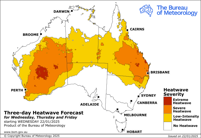
This event is now part of an officially designated heatwave, according to the BoM.

Image: Heatwave map for the next three days, beginning this Wednesday, January 22. Source: BoM.
It might sound strange to have a heatwave in Central Australia and nearby areas, but the term "heatwave" is a relative measure, and even by local standards, this looks to be an exceptionally long spell of heat.