Tropical Cyclone Ilsa expected to intensify rapidly
Tropical Cyclone Ilsa has officially been declared, and is expected to intensify rapidly in coming hours and days,
Just after 2 pm AWST, the BoM issued official notice that the tropical low it had been watching with interest for days had formed into a Category 1 cyclone, with sustained winds near the centre of 75 km/h and gusts to 100 km/h.
It was located approximately 400 kilometres NNW of Broome and 700 kilometres NNE of Port Hedland, moving SW at 13 km/h.
The Bureau also said:
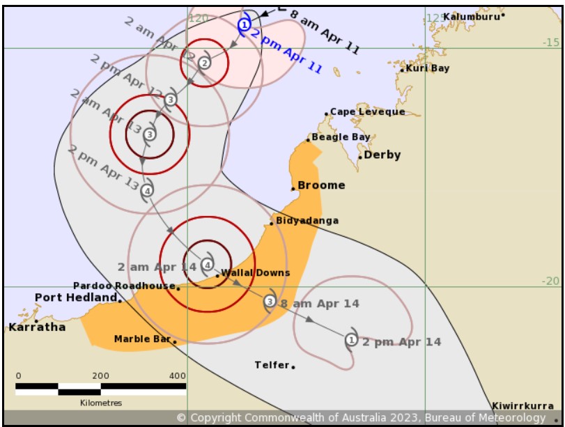
- TC Isla is expected to intensify further during Tuesday and Wednesday as it moves southwest, parallel to the Kimberley coast
- There's a significant risk it will become a severe tropical cyclone on Wednesday
- It is expected to track to the S and then SE during Thursday, with a severe impact likely along the coast and adjacent inland areas between Port Hedland and Broome during late Thursday or early Friday

Image: As you can see, the cyclone is expected to be Cat 4 as it crosses the coast. That means sustained winds close to 200 km/h and gusts well over 200 km/h. Source: BoM.
The last cyclone originating in Australian waters to make landfall on the mainland was Cyclone Ellie on December 22, 2022.
While that storm's winds didn't cause widespread damage, the system was notable because of its persistence as a tropical low which delivered flooding rains far inland for weeks.
There are early indications that Ilsa could also bring heavy rains far inland, albeit to different parts of the interior. But before that happens, its immediate impacts on coastal communities and nearby areas could be far more severe.
We'll keep you posted throughout the week and please keep checking our warnings page for the latest info.