
Tropical Cyclone Alfred to make landfall over the east coast
Tropical Cyclone Alfred is now considered a high chance to push onto the southeast Queensland and northeast NSW coast this week as a category 1 or 2 strength system.
Current position and track
At 11am AEST Sunday, Tropical Cyclone Alfred was a category 2 strength system, with wind gusts of up to 130km/h, and was located about 370km northeast of Bundaberg. It is currently moving through an area of less favourable conditions for intensification. From the satellite imagery below, the lower-level rotation can be clearly seen, with a substantial amount of cloud to the systems’ south.
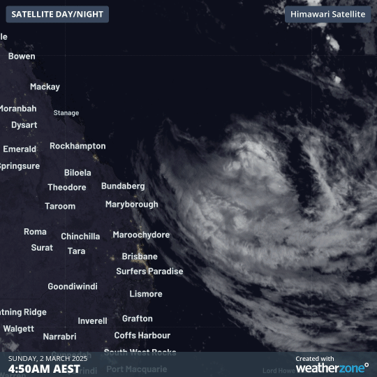
Image: Tropical Cyclone Alfred can be seen rotating off the Qld coast. The separation between the centre of the low and the thickest cloud indicates that wind shear is disturbing its cyclonic structure.
Some effects of Tropical Cyclone Alfred are being felt along the Qld coast. Significant wave heights of 3.5m, and maximum wave heights of 7.1m were recorded at Mooloolaba on Sunday morning, and are continuing to increase. Tides are also running 20-30cm higher than normal along the southeast coast due to the presence of Alfred impacting the base water level in the region.
Alfred is expected to move southeast during Sunday 2nd and Monday 3rd, before running into a ridge of high pressure on Tuesday 4th morning. This ridge will cause Alfred to make a hard turn to the west, putting in on track to make landfall over the southeast Qld and/or northeast NSW coast on Thursday 6th.
Forecast landfall
The current track puts landfall most likely close to Brisbane and the Sunshine Coast, with a high chance it will occur between K’gari (formerly Fraser Island) in Qld and Evans Head in NSW. There is also an outside chance it moves further north near Bundaberg or runs down south along the NSW coast.
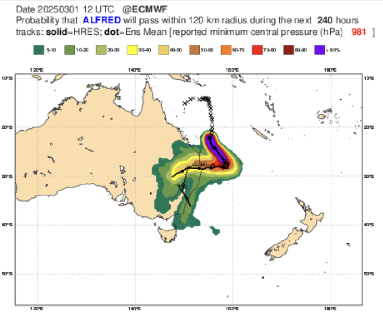
Image: ECMWF ensemble summary of possible tracks for Tropical Cyclone Alfred
Once it makes landfall, it is expected to push inland and south towards the NSW Northern Tablelands, Slopes and Plains. It may impact locations further south as it dissipates next week.
Wind strength
Conditions for intensification will improve for Tropical Cyclone Alfred as it nears the coast, particularly with the very warm water sitting in the East Australian Current (EAC) just offshore. Most likely, Alfred will make landfall as a category 1 or 2 system, packing damaging to destructive winds of 70-110km/h sustained, gusting up to 100-160km/h also the coast and adjacent inland.
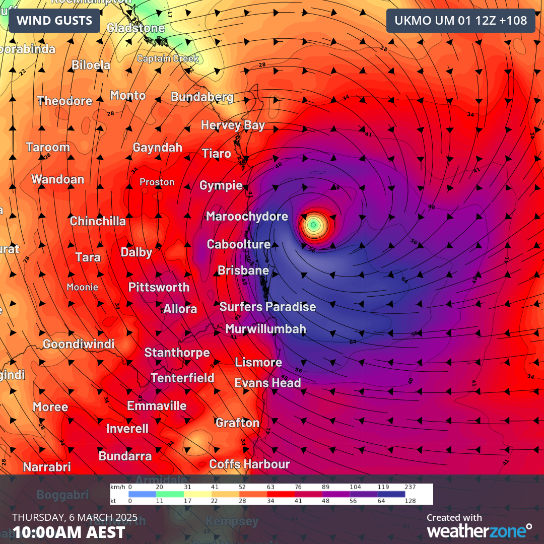
Image: UKMO forecast wind gusts on Thursday 6th ahead of landfall. Areas in dark blue and into white represent destructive wind gusts exceeding 120km/h.
Rainfall and flooding
Regardless of the wind strength of Tropical Cyclone Alfred, one of its most dangerous components will be the rainfall and flooding it brings across southeast Qld and northeast NSW. Past tropical cyclones in this region have been responsible for some of the most intense rainfall rates and most severe floods recorded in Australia, such as the 'Buninyong' Cyclone causing the 1893 floods, and Cyclone Wanda causing the 1974 floods.
While models do vary significantly where the heaviest rain will fall, they are quite consistent on the amounts. Across the entire region, and as far south as Sydney and Wollongong, falls of 50-100mm are forecast.
In the areas most directly impacted, widespread falls of 200-400mm are expected between Thursday and Saturday, with isolated totals of 600-1200mm. Some of this rain will fall in short periods of time, making flash-flooding a high risk. The most exposed locations could see rainfall rates of 100-250mm falling in a six-hour period.
Of particular note, areas in the Logan Valley, Gold Coast Hinterland, Greater Lismore region and possibly the Dorrigo region are areas known to see exceptionally heavy rainfall like those that are forecast and could see the upper end of forecast rainfall.
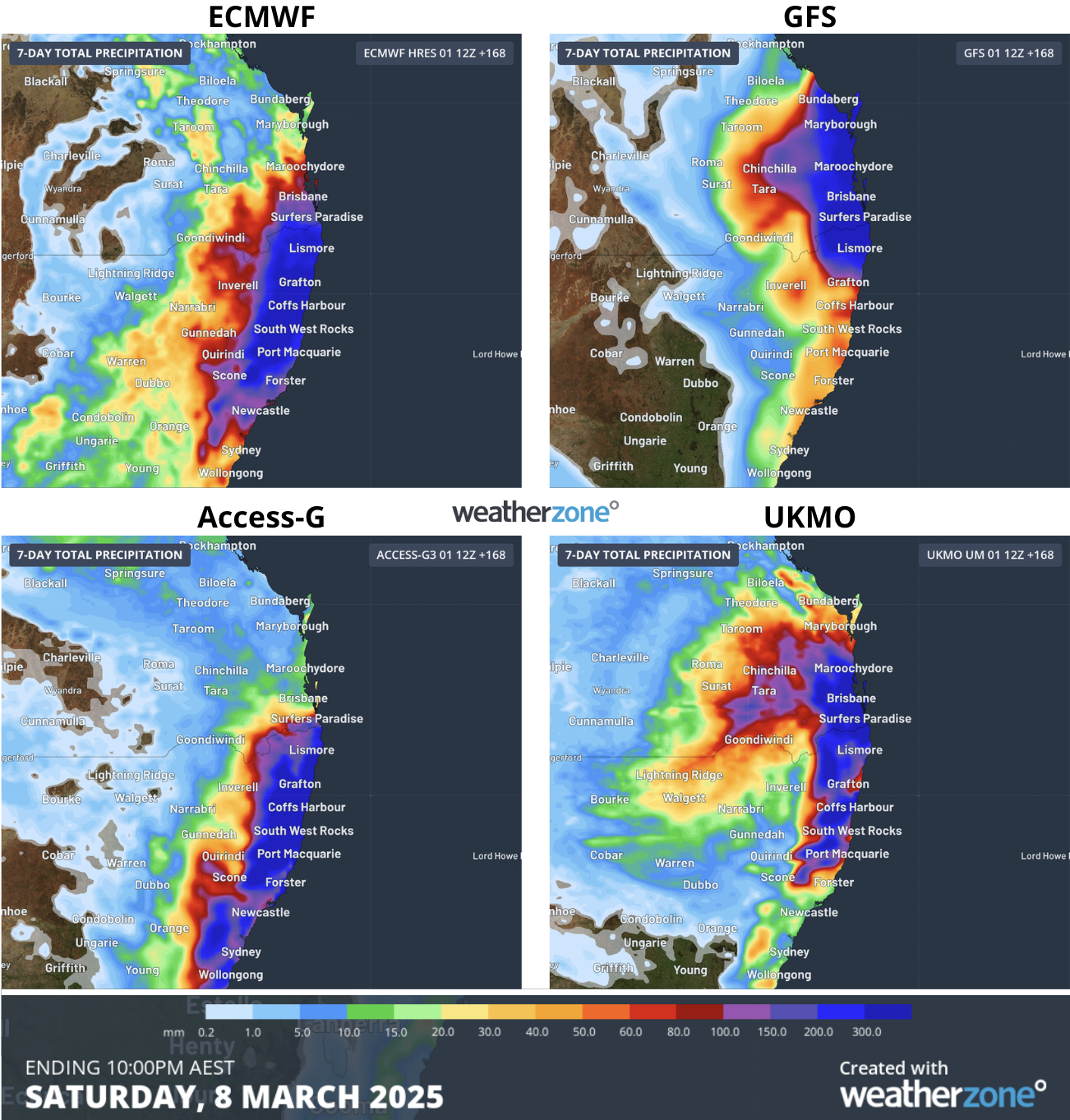
Image: Forecast rainfall from ECMWF, GFS, Access-G and UKMO from Sunday 2nd to Saturday 8th, although nearly all rainfall will fall from Thursday 6th.
Rainfall will be heaviest in the southeast quadrant of the system, where the most moisture, convection, and highest winds will also be. These rainfall rates forecast are heavy enough to lead to widespread major flooding across a number of river catchments. River levels could also near some of the most historic flood levels in the region.
Waves and storm surge
The final major impact of Tropical Cyclone Alfred will be the waves and tides. Due to the systems strength on its southeast side, the Byron Bay area is most likely to bear the brunt of the waves. Significant wave heights of 7-8.5m are forecast, with maximum wave heights upwards of 14-17m possible. This puts it on par with the highest waves recorded off the NSW coast; 17.7m near Eden during the June 2016 East Coast Low. In addition to the waves, a storm surge is possible and will increase the astronomical tide level as it arrives. Beach erosion is likely to be very significant across the coast, with some localised coastal inundation also possible.
This system has the potential to be dangerous and life-threatening, so keep an eye out for tropical cyclone advisories, weather and coastal warnings and further news about this system as we track it during the week.