
Tropical Cyclone Alfred has slowed down – here's why that's dangerous
Tropical Cyclone Alfred slowed down on Wednesday and is now predicted to make landfall later than previously expected, which might expose parts of southeast Qld and northeast NSW to severe weather for longer.
The satellite images in the video below show Tropical Cyclone Alfred spinning to the east of southern Qld on Wednesday.
Video: Satellite images showing Tropical Cyclone Alfred to the east of Australia on Wednesday, March 5, 2025.
One thing that stands out in the animation above is that Alfred appears to stay roughly the same distance away from Australia’s east coast throughout the day, despite drifting a bit further north. In fact, Alfred was about 20km further away from Brisbane at 7pm AEST on Wednesday than it was at 10am AEST the same day.
Alfred stalling off the southeast coast of Qld on Wednesday has a few important implications for people in its future path:
- While Alfred was previously expected to make landfall over southeast Qld on Thursday night or early Friday morning, it is now more likely to approach the coast later on Friday. This will delay the system’s most intense weather.
- Despite still being more than 300 km away from Australia’s east coast, Alfred was already lashing parts of northeast NSW and southeast Qld with powerful winds, squally showers and massive waves on Wednesday. This dangerous weather will now persist for longer and continue to intensify as Alfred approaches the coast on Thursday into Friday.
- Alfred’s storm surge will have the greatest impact on flooding if it coincides with the astronomical high tide, so the timing of Alfred’s coastal approach is important for the extent and severity of coastal inundation and erosion.
One hazard that's already started to impact parts of eastern Australia well ahead of Alfred's arrival is huge surf that's causing coastal erosion in some places. Maximum wave heights of 15.2 metres were observed off the coast of Tweed Heads late on Wednesday morning.
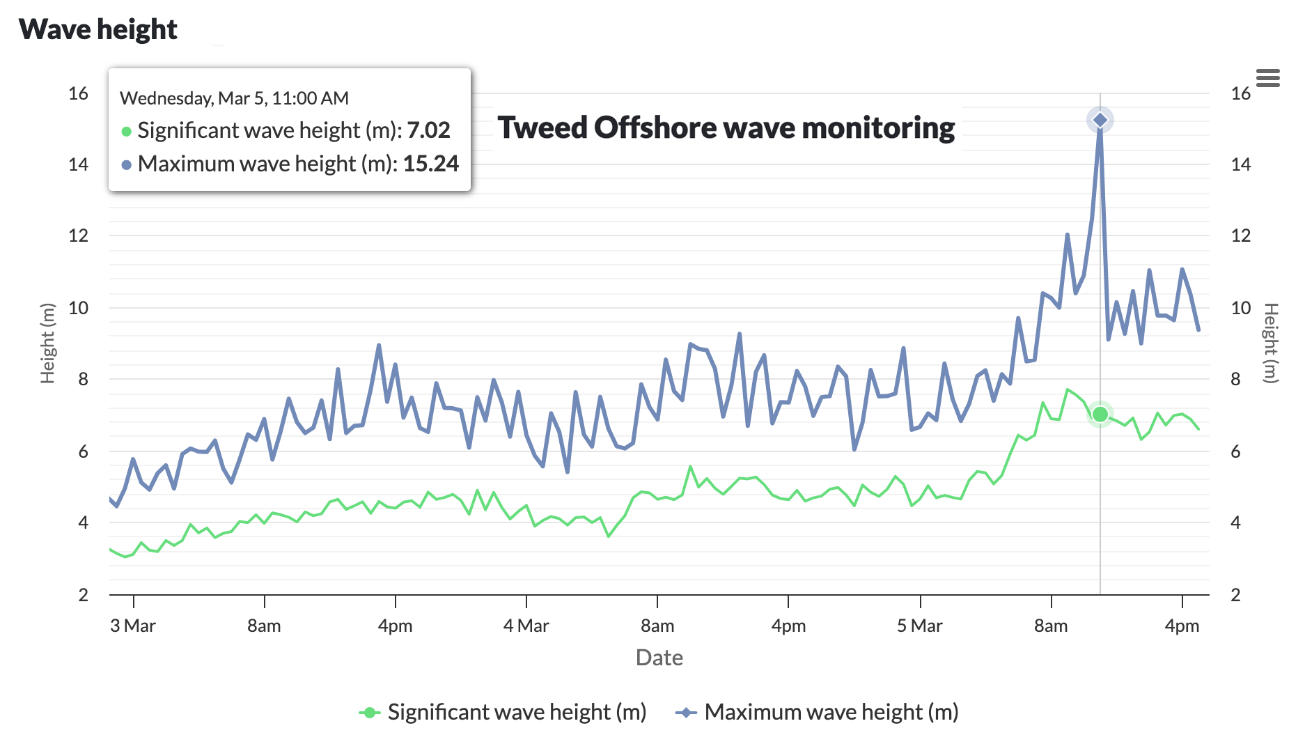
Image: Offshore wave heights near Tweed Heads over the last three days. Source: Queensland Government.
Meteorologists will be closely monitoring the location, movement and strength of Tropical Cyclone Alfred over the coming days because any further deviations from its anticipated track may have implications for its expected impacts. So, be sure to check the latest tropical cyclone advisories, forecast track maps and severe weather and flood warnings from the Bureau of Meteorology in the next few days.