
Tropical cyclone Alfred could disrupt AFL and NRL matches
Both the AFL and the NRL have matches this weekend in Brisbane as part of the opening round of both competitions, and both fixtures look likely to be impacted by Tropical Cyclone Alfred.
Alfred has already tracked further southward than most cyclones originating in the Coral Sea, and is set to be steered towards the coast of southeast Queensland and/or northeast NSW, making landfall this Thursday, March 6, or Friday, March 7.
- This Thursday just happens to be the date of the first game of the 2025 AFL season, with 2024 premiers the Brisbane Lions hosting the Geelong Cats at The Gabba at 6:50pm local time (7:50pm AEDT).
- Then on Friday night, the NRL's Dolphins kick off their third season in the NRL with a home encounter against the South Sydney Rabbitohs at 7pm local time (8pm AEDT) at Brisbane’s Suncorp Stadium.
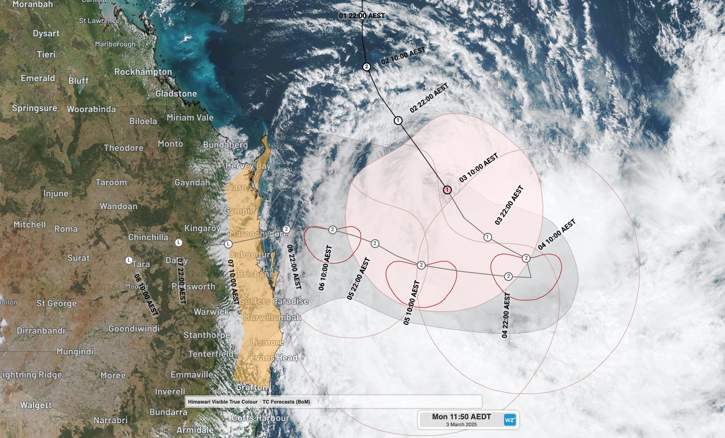
Image: Track map for Tropical Cyclone Alfred, issued just before 11am on Monday, March 3, 2025.
Unlike cricket which can be disrupted by the lightest shower, both football codes can take place in pretty wet, wild weather. But there are limits, and both the AFL and NRL have the ability to reschedule games that have to be abandoned due to extreme weather.
Rain outlook for Brisbane on Thursday and Friday
Alfred has the potential to dump more than 500mm of rain with up to a metre over elevated ranges and hinterland locations in SE Queensland and NE New South Wales. That is an absolutely huge amount – for example, Brisbane's entire annual rainfall is just over a metre.
Places like the Springbrook Plateau west of the Gold Coast often see the heaviest rain with strong coastal low pressure systems (including cyclones), but that doesn't mean Brisbane itself won't cop a drenching.
Rainfall totals of at least 40-80mm can be expected at both Suncorp Stadium and The Gabba (both of which sit on the fringe of Brisbane CBD) on both Thursday and Friday, with the possibility of much heavier falls.
AFL CEO Andrew Dillon says a decision on whether Brisbane's season opener against Geelong goes ahead could be made as late as the day of.
— SuperFooty (AFL) (@superfooty) March 3, 2025
DETAILS | https://t.co/QWKCzNztWi pic.twitter.com/VqEemI6qI2
Wind outlook for Brisbane on Thursday and Friday
The BoM says that destructive wind gusts exceeding 130 km/h are possible on both days. This is in line with the strength of a Category 2 cyclone.
While Alfred was a Category 1 cyclone on Monday afternoon after reaching Category 2 status on the weekend, it is expected to reintensify to Category 2 strength as it turns westwards towards the coastline on Tuesday and crosses areas of very warm water.
Upon crossing the coastline, cyclones inevitably weaken over time as they lose the warm water which is the fuel for their fury. But that can take a day or longer – and it promises to be a wild spell of weather for whichever part of the coastline cops a direct hit.
Whether or not that's Brisbane remains to be seen.
Please check the Weatherzone warnings page for the latest weather info, and the AFL and NRL websites for the latest on the 2025 season schedule.