Thunderstorm outbreak to hammer eastern Australia
Buckle up Eastern Australia, a thunderstorm outbreak is on the way for Monday.
A cold front is moving across southern Australia this weekend, with a connected trough bringing showers across Western Australia today. The front and trough will move across South Australia on Sunday, before colliding with a large pool of unstable air in the eastern states late on Sunday night.
This front and trough will provide a moisture influx into the eastern third of the country, with anywhere from eastern Northern Territory, all the way down to Tasmania likely to see some thunderstorm activity between Sunday night and Tuesday.

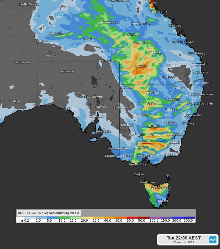
Image: Accumulating precipitation to 10pm Tue 30th August with ACCESS-G
You can see in the image above how widespread this outbreak will be. Large parts of eastern NT, southwest Queensland, western and southern NSW, northern VIC, and northern TAS look likely to see 15-40mm of rain on Monday, with some areas in line for 50-80mm.
There is a decent chance that we will see some severe storms within this outbreak as well, particularly on Monday, as the front and trough move through VIC, NSW and QLD. Storms could generate damaging-to-destructive wind gusts, large hail and torrential rain leading to flash flooding.
On Tuesday, the trough will move east through NSW and QLD, continuing to bring showers and thunderstorms, this time for northern NSW, and inland southern QLD. Thunderstorms on Tuesday should be less widespread before more settled weather returns to the north on Wednesday. Unfortunately for the southeast, the front will drag more cold air up from the Southern Ocean, leading to a few chilly days early next week.
You can keep up with the latest warnings and information here.