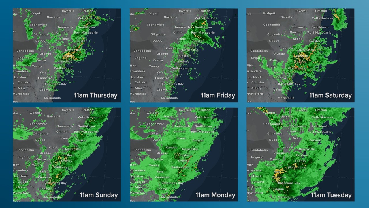
The Sydney deluge captured in six dramatic radar images
These are the images that say it all about the Sydney deluge.
They're a snapshot of the radar over the Sydney region at 11 am on each of the six days of heavy rain from Thursday last week to Tuesday this week.

Sydney's Observatory Hill weather station, located at the southern end of the Sydney Harbour Bridge, received a total of 307 mm of rain over the six day period ending at 9 am on Wednesday morning.
Weather stations across the metropolitan area recorded similar readings, with totals in excess of 400 mm in some suburbs.
While the rain was torrential at times, it was the relentless, uninterrupted steady rain which made this event noteworthy. A large mass of rain-bearing cloud seemed to park itself over the city - as well as other areas of the NSW coast - for the best part of the week in a persistent moist easterly flow.
Some readers have asked on our Facebook page why the NSW coast tends to receive such persistent falls in major rain events, while heavy rain events in southern capitals like Melbourne, Hobart, Adelaide, and Perth seem to come and go more rapidly.
"Sydney is in the 'sweet spot' in that it is far enough south that cold fronts regularly affect it, but still far enough north that tropical air can regularly reach it during the summer/autumn months," Weatherzone meteorologist Joel Pippard explains.
"The East Australia Current brings warm tropical waters south from near the equator. Warmer waters mean more moisture in the atmosphere."
"It’s also worth mentioning that Sydney's rain events seem to last so long because of the type of systems that usually bring the heavy rain are inherently slow-moving.
"Weather typically moves from west to east, so to have large scale easterly winds, there needs to be a large 'blocking' high over the Tasman Sea or near New Zealand, which helps keep the weather pattern stable.
"The other southern capitals receive most of their big rain events from systems that interact with a cold front in some way, meaning they often move away within a day or two."
The good news is that the sun is now well and truly out in Sydney, with temperatures tipped to reach 30 degrees this Wednesday, with more clear weather for at least the first half of Thursday before the chance of afternoon and evening showers.
The bad news is that the flood situation in the city's west has not yet fully eased. You can keep up with the latest SES notifications here and the latest official warnings for the whole of NSW, as well as flood-affected parts of southeast Queensland and Victoria's Gippsland region here.