
The 'perfect weather' road trip
Ever wanted to take a road trip, but the weather just didn't permit? Or perhaps, you need some inspiration for which direction to drive? The possibilities are almost endless across a vast continent. Where would you start?
What if it were said that you could take a route during any time of the year and have the average maximum daily temperature always be, say, between 24 and 25 degrees Celsius?
Inspired by Brian Brettschneider, a climatologist hailing from Alaska, who created a '70ºF [21ºC] Road Trip' across an entire year in the United States, a route has been constructed over Australia using similar concepts. The 2023-updated version can be found on Brian's blog, here.
For Australia, there are not enough locations, particularly in summer, that have a maximum daily temperature of 21ºC. So, for the generated map, this has been bumped up to anywhere between 24ºC and 25ºC - better beach weather anyway, right?
This data has been extracted from the Bureau of Meteorology's 'Average monthly and annual temperature maps', found here. Then, after collating the data per month and aligning it with latitude and longitude then overlaying it on a roadmap, the following route was achieved.
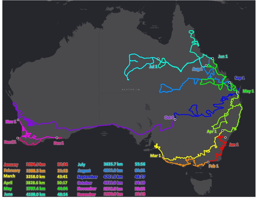
Figure: Map routing almost 500 hours of driving covering nearly 40,000km over an entire year, with the maximum daily temperature almost always being between 24-25ºC according to average monthly 30-year climatology (1991-2020). The numbers at the bottom show the length of the route in kilometres and the driving time in hours and minutes (Data from BoM, 2021 & analysed in QGIS, 2023).
Here's a closer look at groups of months, in case you don't have a full year to spare.
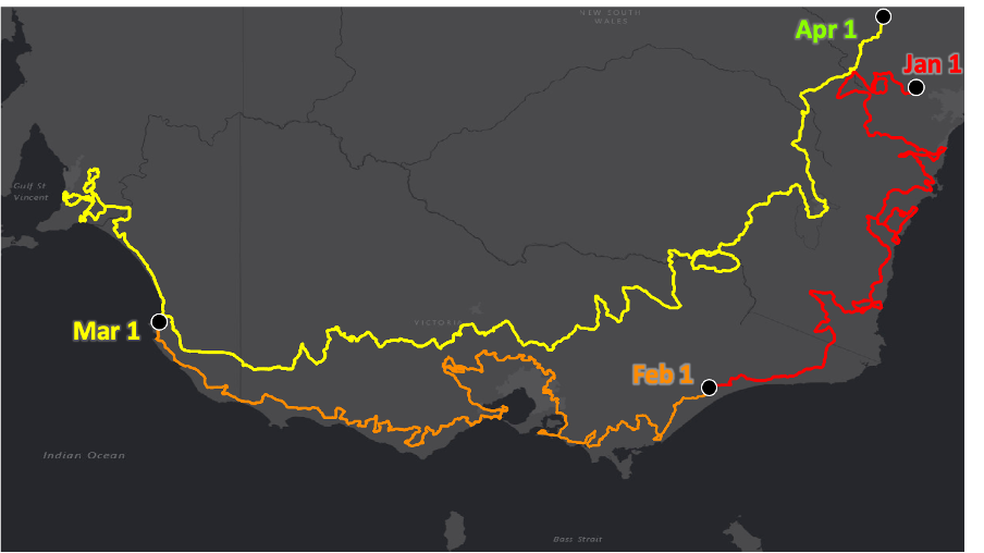
Figure: The January, February and March route where the average daily maximum temperature is between 24-25ºC. January: 2094.5km; February: 1988.5km; March: 3258.0km (Data from BoM, 2021 & analysed in QGIS, 2023).
Starting west of Sydney in the Blue Mountains on New Year's, this route will take you through a portion of the Central Tablelands before snaking down through the South Coast, stopping at various small cities and towns along the way. You can then go through the Snowy Mountains Area before crossing the border and reaching the east Victorian coast.
From February, stick as close to the coast as you can if you want to keep the 24-25ºC range. Head west and touch the outskirts of Melbourne, before gracing the southwest including parts of the Great Ocean Road.
In March, venture your way up SA's South East coast and into Adelaide. Then, head east and into Victoria, but this time through the Central Highlands. Maintain your latitude as you head through Hume, then once crossing the border, get your final sightings of the Central Tablelands and slopes.
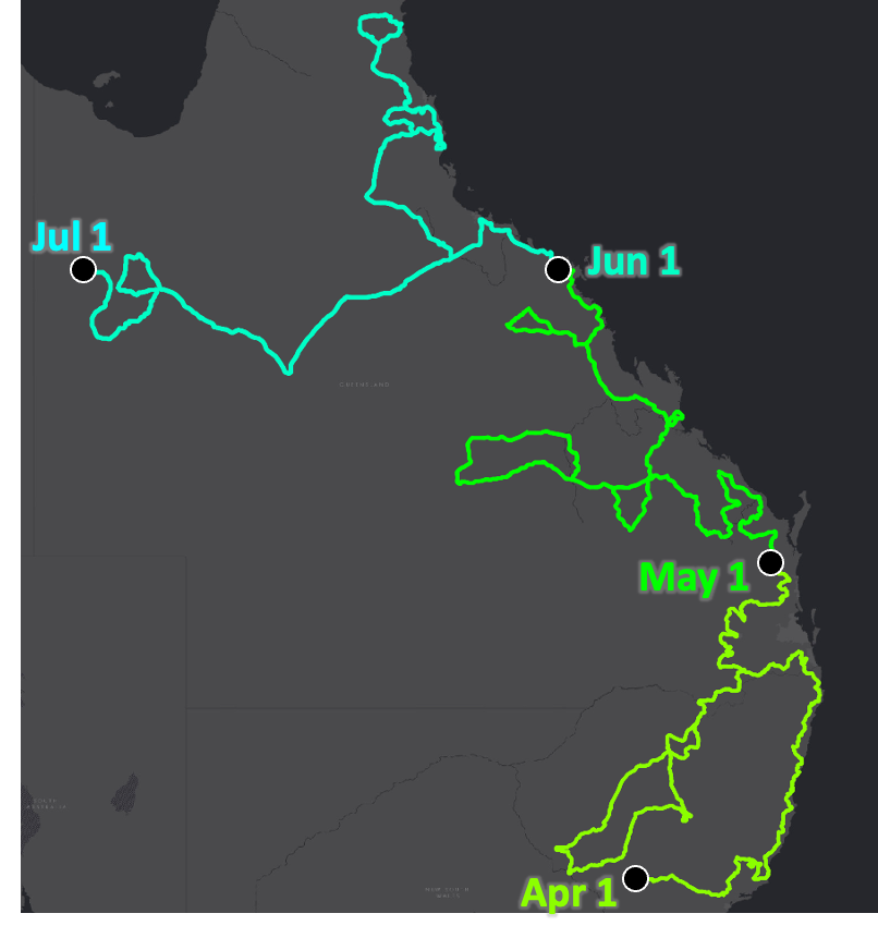
Figure: The April, May and June route where the average daily maximum temperature is between 24-25ºC. April: 3828.6km; May: 3797.4km; June: 4108.0km (Data from BoM, 2021 & analysed in QGIS, 2023).
From the beginning of April, find yourself navigating the Central-West Slopes before heading directly east towards the northern NSW coast. A detour can take you back inland to see the North Western Slopes, ideal for stargazing, before heading up past the QLD border and towards the Sunshine Coast.
During May, enjoy your time gliding through central QLD, navigating through Bundaberg, Rockhampton, Mackay the Big Mango, and... welcome to the tropics!
In June, you can travel the furthest north whilst still maintaining the 24-25ºC maximum temperature. Enjoy Townsville, and Far North Queensland including Cairns, the Daintree, all with the Great Barrier Reef to your east. That is, until you venture inland towards Cloncurry and Mount Isa.
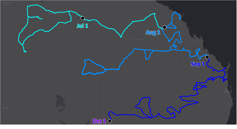
Figure: The July, August and September route where the average daily maximum temperature is between 24-25ºC. July: 3635.7km; August: 4812.0km; September: 4201.0km (Data from BoM, 2021 & analysed in QGIS, 2023).
From July, continue west and cross into the Northern Territory, where you’ll eventually hit the Stuart Highway. Head south and check out Alice Springs, before retracing your tracks back through Cloncurry and heading back into tropical east QLD.
In August, you may some familiar central QLD territory, but heading into the interior towards Longreach then Birdsville will be yet unchartered. Head back east and finish up near Bundaberg.
September will see a significant southward traversing as springtime heats up the north. Catch a glimpse of the coast one last time before heading into the outback once again, crossing the NSW border this time at the North West Plains.
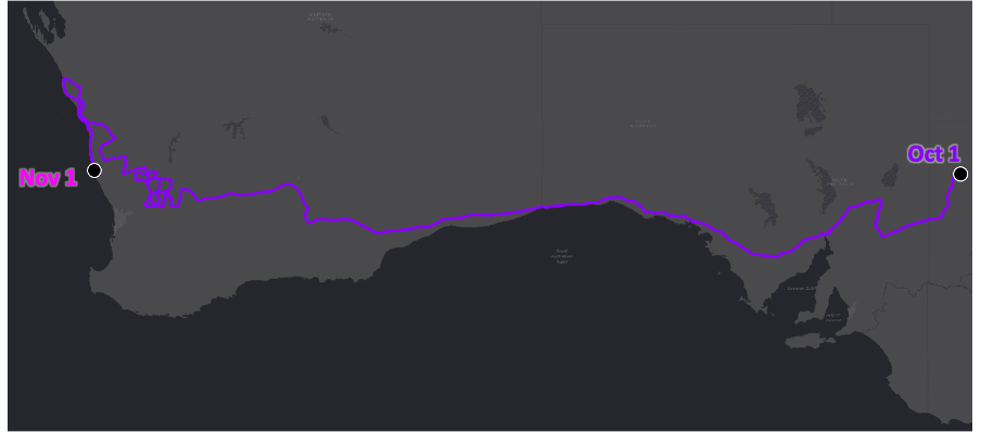
Figure: The October route where the average daily maximum temperature is between 24-25ºC. October: 4939.0km (Data from BoM, 2021 & analysed in QGIS, 2023).
October will constitute the longest monthly journey yet, as the beautiful 24-25ºC temperatures sit snugly along the Bight coast. Cross through the Nullarbor Plain and slither your way through the Wheatbelt region, then catching a glimpse of Geraldton before heading down the coast.
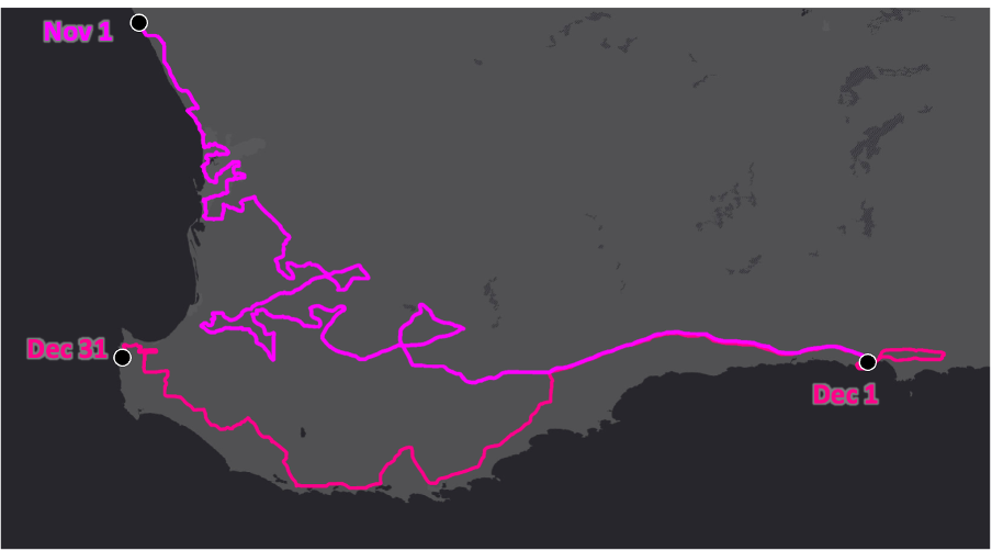
Figure: The November and December route where the average daily maximum temperature is between 24-25ºC. November: 1918.0km; December: 1090.0km (Data from BoM, 2021 & analysed in QGIS, 2023).
In November, officially within the Wheatbelt region again, navigate through Perth then explore the forests east of Bunbury, before heading east again through the Goldfields Area and to Esperance.
In December, head back west again, but not without exploring Pink Lake. Wonder through the South West Region and hug the coast, before reaching wine region and Busselton by Christmas and into the New Year.
So there you have it, the annual 'perfect weather' road trip. By no means will this ensure the temperature will always be between 24-25ºC - in fact, this data uses temperature values from the 1990s, and a lot has changed with the climate since then.
What’s more – if you can't make a full year, you can pick a month to travel if you wish. Accommodation, petrol and shops have been strategically placed frequently along the route. Happy travelling!