
The biggest Australian weather stories of 2022
What a year. This will be remembered as a wet year in Australia, with La Niña dominating local weather across large parts of the country. But as always, there was plenty of remarkable weather of all types in all states and territories.
Here's our quick rundown of the some of the most significant weather events, month by month, as we covered them here in our news feed at Weatherzone.
JANUARY
First Aus 50-degree day this century
January 13, 2022, was an historic day: the 50.7°C reading at Onslow Airport in northwest WA was the first time this century that any Australian location has reached the 50-degree mark. It was also WA's hottest temperature and the equal-hottest Australian temperature ever recorded.
Heaviest Aus rain day in 3 years
A whopping 674 mm of rain fell in 24 hours at the weather station at the rural locality of Marodian, about 40 km southwest of Maryborough (Qld) in the catchment of the Mary River. This was the highest 24-hour rainfall tally anywhere in Australia since 2018. As you'd imagine, flooding was severe.
FEBRUARY
Perth's hottest summer
Early in the month we wrote that Perth was on track for its highest number of 40-degree summer days, and so it turned out. In fact, the WA capital had its hottest summer on record, with an average max temp of 33.3°C – a whopping 2.5°C above the long-term average.
Heavy outback rain
It started in the last days of January but spilled into February, as Broome Airport recorded a 120-year high of 563 mm of rain in 48 hours – more than it received during the whole of 2021! Meanwhile for the second time in three months, Alice Springs saw more than 100 mm within the space of three days or less, and the normally dry Todd River again raged.
Record Brisbane rainfall
Brisbane broke two major rainfall records late in the month – with a three-day total of 676.8 mm and a weekly total of 795 mm. Widespread flooding ensued, and tragically, six people lost their lives in or near the city.
MARCH
Unbelievably soggy Sydney
Heavy rain in February (total 356 mm) ensured that Sydney recorded its wettest summer in 30 years, but that was just a sign of an extremely soggy year to come. Sydney would go on to register its wettest March on record with 554 mm. Normally the heaviest monthly rainfall totals occur along Sydney’s coastal fringe, but Penrith in the city's outer west recorded even more than the city, with 592.8 mm. Flooding was widespread.
Lismore floods
If one single event defined 2022, it was surely the Lismore floods, although the list of places that flooded in March was long, and included places as geographically diverse as Byron Bay and Broken Hill.
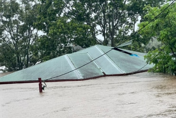
Image: Water was literally up to roof level in Lismore. Source: Eddie Lloyd.
APRIL
More heavy rain (but no bombs)
There was yet more heavy east coast rain, as Sydney exceeded its annual average rainfall less than a third of the way through the year. But did it experience a "rain bomb" as many media outlets reported? As our story explained, no!
Surprisingly quiet tropical cyclone season
Australia's tropical cyclone season runs from the start of November until the end of April. Like the previous season, the 2021/22 season was quieter-than-average despite La Niña, which usually helps boost cyclone numbers. There were nine tropical cyclones that formed in or moved through Australia's area of responsibility, two of which made landfall over Australia. The long-term average for the Australian region is 9 to 11 tropical cyclones and four coastal crossings, according to the BoM.
MAY
Heavy flooding in SE Qld and Tas
Queensland and Tasmania are two states you don't often see mentioned together in weather, but we've thrown them in together here, because both saw exceptionally heavy rain in their southeast corners. The Tassie rain was particularly noteworthy, not just because it was so heavy, but because it fell in the (normally much drier) eastern half of the state. Southwestern Tasmania, which is Australia's wettest non-tropical area, continues to experience a rainfall deficit by historical standards, something we wrote about in March.
JUNE
Best start to Aussie snow season in decades
It was actually the best start to an Aussie snow season since 1968, after back-to-back blizzards – the first of which started in the last two days of May – left over a matre of snow in the higher mainland ski resorts. The ski season went on to be a beauty, with a peak season depth of 232 cm at Snowy Hydro's measuring site at Spencers Creek, NSW. That's around 10% higher than the average peak depth in the data set going back to 1954, although it's worth noting that the snow at lower elevations was extremely patchy this winter, and often non-existent.
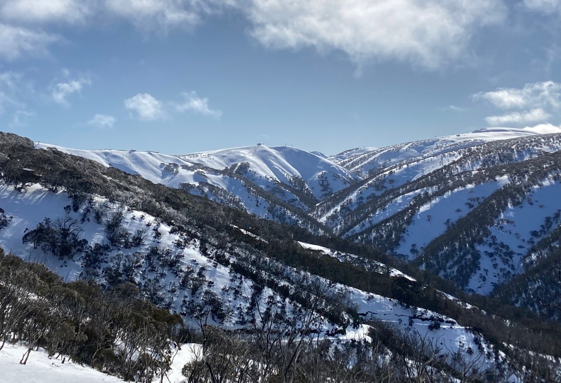
Image: The slopes of Mt Hotham in Victoria were absolutely caked early in the season. Source: Author's pic.
JULY
Yet another east coast deluge centred around Sydney
After 300 mm in 48 hours recorded in parts of the Sydney metro and Illawarra regions, plus a whopping reading of 521 mm at one location, Sydney itself would go on to register a record total of 404 mm of rain in July, the second-wettest month of a very wet year.
AUGUST
Rare winter warmth for Tassie
Towards the end of the month, Hobart recorded a 21-degree day, while Strahan on the state's west coast registered its warmest August day in records dating back to 1971, after reaching 22.5°C. Interestingly, Tasmania had an exceptionally poor snow season, with little skiable snow all winter at its two small ski hills. This was in stark contrast to the mainland.
SEPTEMBER
Wet start to spring
There was flooding in four states after a relatively slow-moving rainband drenched eastern Australia early in the month. As Weatherzone meteorologist Ben Domensino pointed out at the time, the combination of a low pressure trough, cold front and a low pressure system being fed by abundant moisture coming from the oceans surrounding Australia is a normal kind of set-up for September.
But the atmosphere was loaded with more moisture than usual thanks to three active climate drivers: The negative Indian Ocean Dipole (IOD) to the northwest of Australia, a La Niña-like pattern to the northeast of Australia, and a positive Southern Annular Mode (SAM) to the south of Australia.
OCTOBER
You guessed it, more record-breaking NSW (and ACT) rain
On the 6th day of the month, Sydney surpassed its longstanding annual rainfall record of 2194 mm. By the 24th, it had also shattered its October rainfall record, and ended up receiving 295.4 mm for the month (for the record, Sydney would top 2500 mm by the end of December). But it wasn't just Sydney copping a drenching. Canberra had its wettest October on record with 166.2 mm, in what has been one of its wettest years on record. Outback NSW also copped some serious rain in October, all the way out the back o' Bourke.
Devastating Victorian and Tasmanian floods
Also this month, our two southernmost states, Victoria and Tasmania, got a taste of what eastern NSW and southeastern Queensland had experienced all too often in 2022, with severe floods which one local told Weatherzone was the worst he could remember. Extremely heavy falls by Victorian standards, including 224 mm in two days at Strathbogie North, inundated rivers like the Goulburn and other major tributaries of the Murray. All that water soon flowed through towns like Shepparton and Echuca, which experienced severe flooding under sunny skies when the system that brought all the rain was long gone.
NOVEMBER
Late spring Aussie avalanches!
Melbourne Cup Day was one of many freezing November days down south, and the unseasonable cold fronts that swept through the southeast delivered frequent snow to the Alps. One fall was so heavy that avalanches were triggered in the NSW back country.
Adelaide's most intense thunderstorm in years
Thousands were without power as intense storms moved through southeastern SA. A rare combination of factors caused the devastating storm outbreak, which we explained in this story.
DECEMBER
Cool start to summer down south, hot start up north.
Australia equalled its coldest summer temperature on record, when Perisher Valley in NSW dipped to -7°C on the morning of December 9 after yet another out-of-season cold front. Most of the southern capitals have had a relatively cool December in relation to their long-term averages, while even Brisbane failed to top 18°C during daylight hours one particularly unsummery summer day. Meanwhile there was a heatwave in WA, NT and parts of Qld and SA.
Wherever you are in Australia, we hope the weather is kind to you in 2023.