Sydney's coldest day in five years
If you thought Thursday was a bit cold in Sydney, even for the start of winter, you weren't imagining it. Plagued by persistent clouds and rain, the city just had its coldest day in five years.
A low pressure trough passing over NSW on Wednesday and Thursday caused a large mass of rain-bearing clouds to drift across the state.
This wet and cloudy weather reached Sydney on Thursday morning and lingered over the city for the entire day.
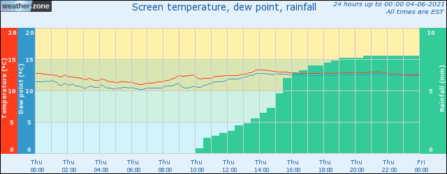
As you can see on the graph below, rain was accumulating fairly steadily between about 10am and 7pm. This prevented the temperature from rising, with the red line in the graph nearly flat throughout the whole day.

Image: Temperature and rainfall observations from Sydney's Observatory Hill weather station on Thursday, June 3.
The highest temperature at Sydney's Observatory Hill weather station on Thursday was 13.4ºC at 2:23pm. This is the lowest daily maximum temperature since June 2016.
It was also the coldest day in five years for Bankstown (12.9ºC), Horsely Park (12.4ºC), Canterbury (13.4ºC) and Olympic Park (13.4ºC).
Impressively, Richmond (11.8ºC) registered its equal lowest maximum temperature in a decade.
Friday will be noticeably warmer across the Sydney Basin, with temperatures reaching about 19-20ºC across most suburbs.