
Summer 2023-24 outlook for Australia
Australia has entered summer 2023-24 under the influence of a moderate El Niño and a positive Indian Ocean Dipole. So how will these climate drivers influence Australia’s weather throughout the season and what can you expect to see in your part of the country during the next three months?
Climate drivers this season
The main climate drivers that affect Australia’s weather on a seasonal scale are the El Niño-Southern Oscillation (ENSO), the Indian Ocean Dipole (IOD) and the Southern Annular Mode (SAM).
El Niño lingering
The El Niño-Southern Oscillation is currently in an El Niño phase, which has been occurring for several months and is likely to persist throughout summer.
El Niño has a strong influence on Australia’s weather during winter and spring, typically causing below average rain and above average temperatures. However, the maps below show that El Niño’s influence on Australian rainfall declines in summer.
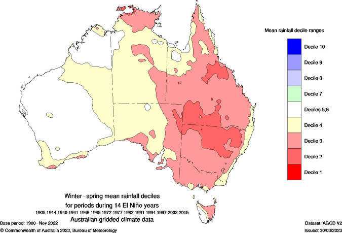
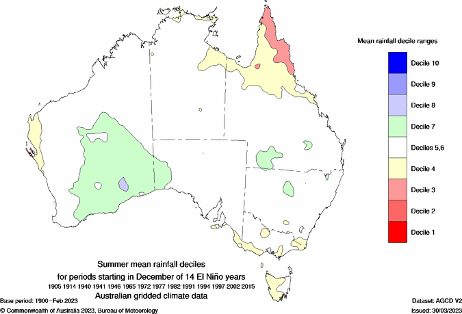
Images: Observed rainfall deciles in winter-spring (top) and summer (bottom) during 14 El Niño events between 1905 and 2015. Source: Bureau of Meteorology.
While El Niño has less influence on rainfall in summer, it does still promote above average temperatures across most of the country, particularly during the night.
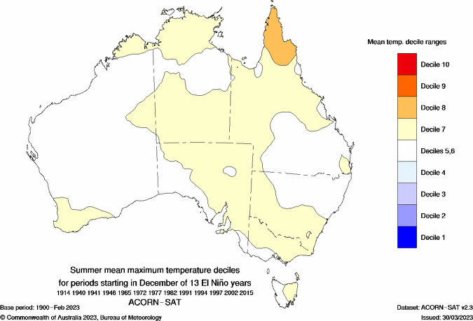
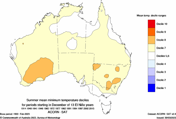
Images: Observed mean maximum (top) and minimum (bottom) temperature deciles during 13 El Niño events between 1905 and 2015. Source: Bureau of Meteorology.
Positive Indian Ocean Dipole (IOD)
The Indian Ocean Dipole (IOD) is in a positive phase as the start of Australia’s 2023-24 summer. This event is expected to persist into December but should break down quickly when the monsoon arrives in norther Australia. Most forecast models suggest the positive IOD will come to an end in January.
The positive IOD will increase the likelihood of above average temperatures and below average rain in some parts of Australia during December, before losing its influence from January.
Southern Annual Mode (SAM)
The Southern Annular Mode (SAM) is expected to be in a neutral phase during the opening fortnight of summer. However, El Niño events can increase the likelihood of negative SAM phases, so neutral to negative SAM episodes are the most favoured phases this summer. A neutral SAM has little influence on Australia's weather, while negative phases are typically associated with abnormally warm and dry weather for most of southeastern Australia, with the exception of western Tasmania.
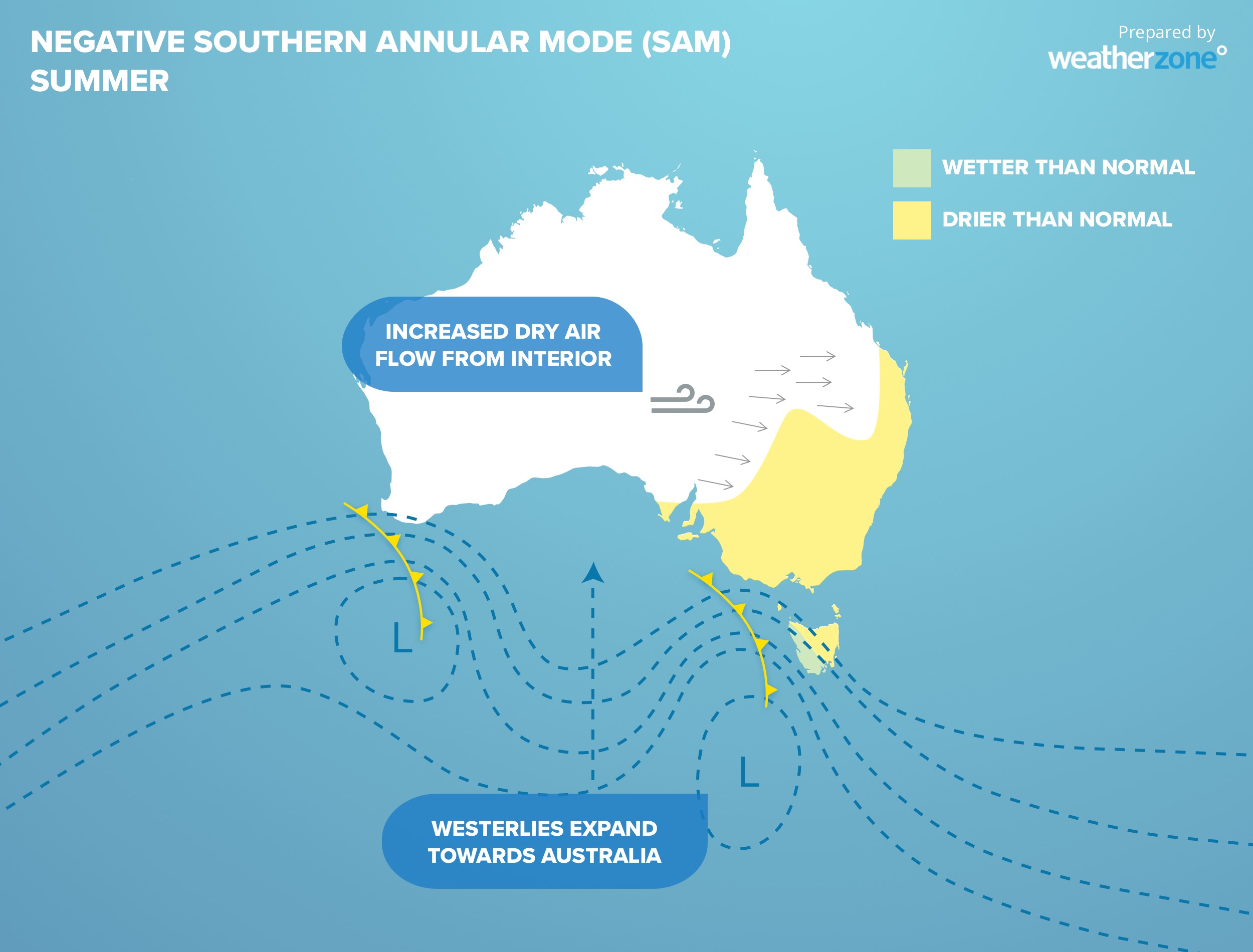
Image: Typical impacts of a negative SAM in summer, with stronger westerly winds causing below average rain over much of southeastern and eastern Australia, and wetter-than-average weather in western Tas.
Climate Change
In addition to the climate drivers mentioned above, Australia’s weather will be influenced by the background effects of climate change this summer.
Australia’s mean national temperature in summer has warmed by 1.47ºC since 1910. The strongest warming trend in summer over the last 50 years has been over Australia’s central and eastern inland.
There have also been some notable trends in summer rainfall over the last five decades. Since 1970, summer rainfall has declined over large areas of Qld, NSW and parts of Vic, Tas, SA and the NT, and increased over parts of northern, western and southern Australia.
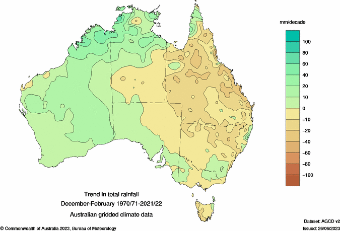
Image: Observed trend in summer rainfall between 1970 and 2022. Source: Bureau of Meteorology.
Temperature
Temperatures are expected to be generally higher than average for most of Australia this summer. El Niño also brings an increased risk of higher temperature extremes, but a lower risk of prolonged heatwaves in southern parts of the country.
If negative phases of the SAM develop this summer, which is to be expected under El Niño, parts of Tasmania and Victoria may see temperatures remaining closer to the long-term-average.
With the combined influence of El Niño, negative phases of the SAM and climate change, this summer has an increased chance of producing seasonal average temperatures that rank in the top 10 percent of historical records for some parts of Australia.
Rainfall
Rainfall may be slow to get going in some parts of Australia this summer in response to a delayed monsoon in northern Australia and the tail end of the positive IOD. However, once the wet season ramps up in the tropics, some parts of the country could see near to above average rain through the middle and latter part of the of the season.
Northern Australia is the most likely area to see below average rain this summer, due to its ongoing link to El Niño at this time of year. Elsewhere, rainfall will be more strongly influenced by local sea surface temperatures and the Southern Annular Mode. With the potential for warmer-than-average water temperatures around most of Australia and negative phases of the SAM, rainfall could be near or above average in southern and southeastern Australia this summer.
Abnormally warm sea surface temperatures in the Tasman Sea should bring an increased risk of flash flooding over eastern Vic and eastern NSW this summer, especially with storms.
Thunderstorms
Summer is the peak season for thunderstorms in northern Australia, eastern areas of Qld and NSW and the western inland of WA.
Image: Average lightning density in Australia during summer, displayed as lightning pulses per square kilometre per season, based on observed lightning between 2015 and 2021.
This season is likely to see reduced thunderstorm activity over northern Australia due to El Nino’s suppression of wet season. By contrast, thunderstorms are likely to be more active than usual over eastern Australia, including Qld, NSW and Vic, partially in response to warmer-than-average sea surface temperatures off the country’s east coast providing more fuel for storms. Thunderstorm activity should be near average over the rest of the country, including central, southern and western Australia.
Any severe thunderstorms that develop outside the tropics this season will bring an increased risk of damaging wind gusts and dry lightning this summer.
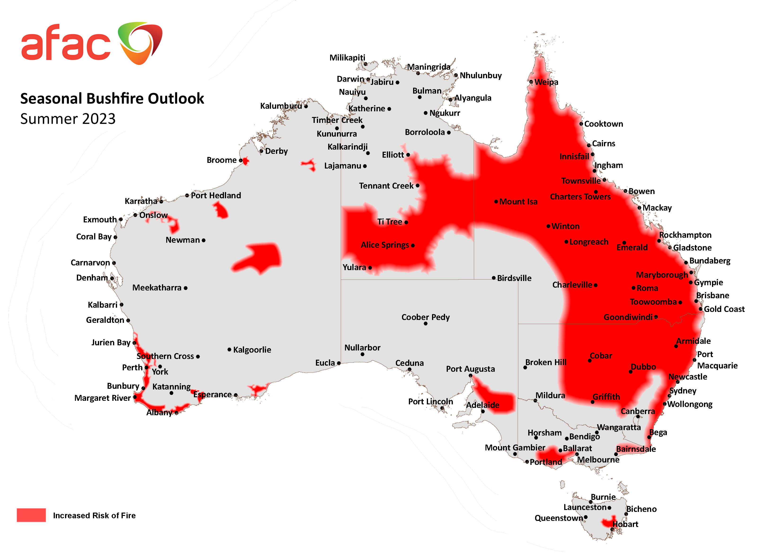
Fire
There has been prolific vegetation growth in some regions on the back of three consecutive years of La Niña and wetter than average conditions. This vegetation has been drying out this year after a record-breaking dry spell in the first two months of spring and unusually warm temperatures in recent months.
Fortunately, increased rain and thunderstorm activity in November has helped increase root zone soil moisture in parts of eastern Australia, which will help mitigate the fire risk in some areas heading into summer.
Despite this recent rain, the warm and dry conditions forecast in summer brings an increased fire risk to large areas of NSW, Qld and the NT, and parts of SA, TAS, VIC, especially in areas that missed out on heavy rain in November. Normal fire risk is forecast for the ACT after a wet November and normal summer rainfall forecast.
Tropical Cyclones
This season will be influenced by a moderate El Niño event that is predicted to persist until at least the end of the Southern Hemisphere’s summer. This increases the likelihood that Australia will see a below-average number of tropical cyclones over the next few months. In an average season there are usually 9 to 11 tropical cyclones in the Australian region. During El Niño, this average drops to 7 to 8 tropical cyclones.
It’s important to point out that a quiet season in terms of overall numbers does not mean it won’t be a dangerous season. It only takes one landfalling tropical cyclone to cause damage to communities and infrastructure in northern Australia. At least one tropical cyclone has made landfall in Australia every year since reliable records began.
Summary
This summer will be influenced by El Niño, a decaying positive IOD, predominantly neutral to negative phases of the SAM and the background effects of climate change.
- Temperatures will generally be warmer than average for most of Australia this summer, with an increased risk of heat extremes.
- Rainfall and thunderstorm activity will most likely be below average in the country’s north but may be close to or even above average in parts of southern and southeastern Australia.
- Drying vegetation will increase the risk of bushfires over large areas of eastern and central Australia this summer, along with pockets of the south and west.
- Tropical cyclone activity will most likely be lower than average due to El Niño, although tropical cyclones will still pose a risk to life and property in northern Australia this season.