Strong cold front crossing the southeast
There's a word that the BoM usually only pulls out of its meteorological dictionary in winter, and that word invariably means severe weather is lashing the southeast of the country.
The word is "vigorous" and it applies to cold fronts that bring damaging winds, widespread showers and hail, as well as snow to alpine areas and sometimes lower.
As the BoM says in its severe weather warning for southern parts of NSW, a "vigorous cold front" is crossing southeastern Australia this Tuesday. Numerous warnings are in place, including gale warnings for parts of South Australia, Victoria and Tasmania, and severe weather warnings for parts of NSW, Victoria, Tasmania and the ACT.
In systems like these, winds are often stronger ahead of the front (than after it has passed) due to a higher temperature gradient in front of the front.
- Already this Tuesday, a gust of 143 km/h has been recorded at Maatsuyker Island, the notably windswept speck off Tasmania's southwestern tip
- A gust of 100 km/h was recorded at Mt Buller in the Victorian Alps
- A gust of 95 km/h at Perisher Valley in the NSW Snowy Mountains.
The coldest air from this system has not yet reached Australia, but the "feels like" temps are still pretty low due to those blustery northwesterly winds, and the air temperature is still cold enough for snow to be settling down to about 1500 metres at most mainland ski resorts.
Several centimetres of fluffy white stuff had already accumulated by Tuesday lunchtime at Mt Hotham, as you can see below. It's a welcome sight after slopes were bare right across Australia outside of snowmaking areas for the traditional June long weekend season start.
11:30am update. The #snowfalls continue at #Hotham! ?????? pic.twitter.com/dMQwDnuvHA
— Hotham (@_hotham) June 11, 2024
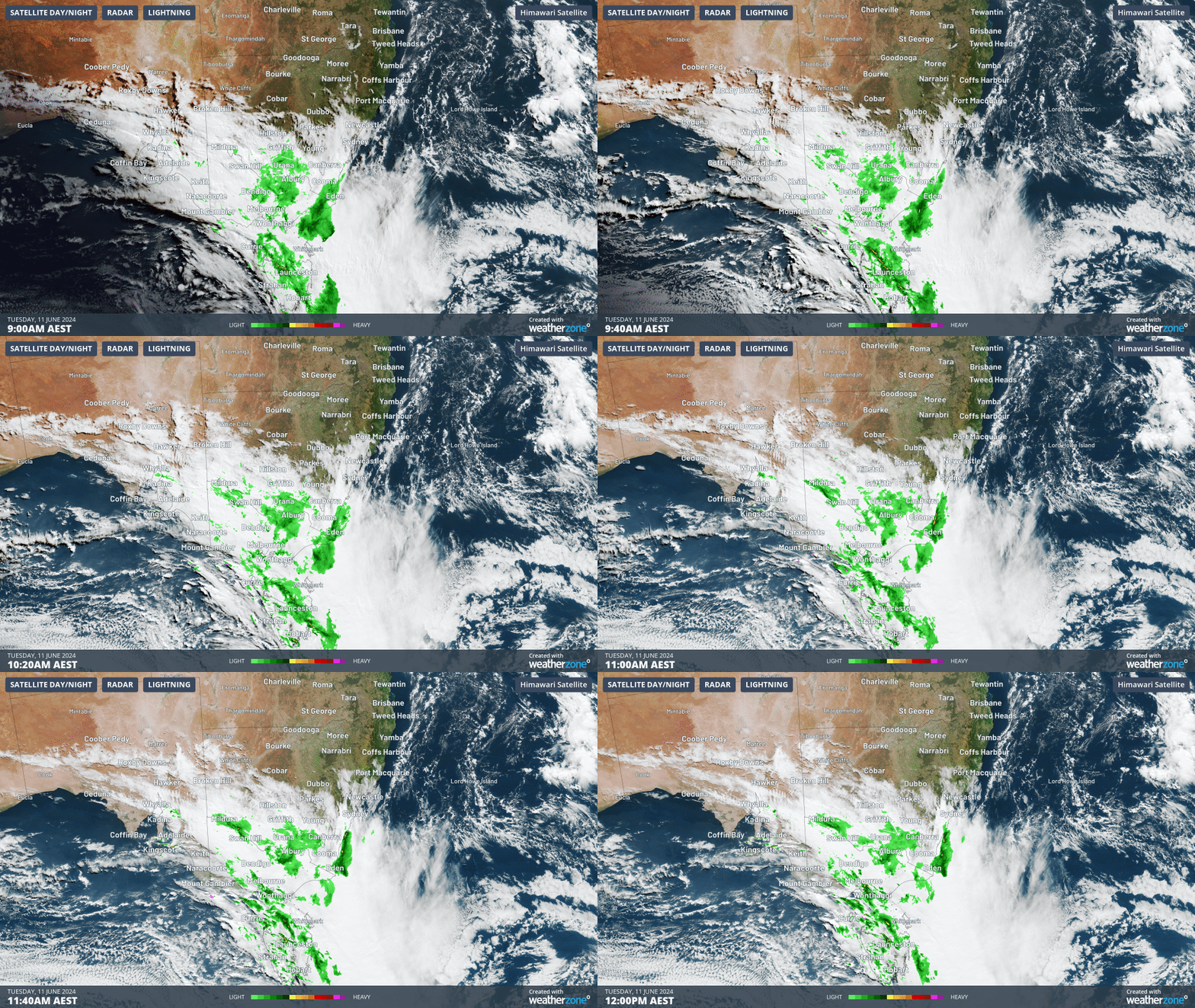
As the three-hour loop up till midday Tuesday shows, there’s inland rain associated with this system, with light falls recorded across almost all of Victoria since 9 am, and heavier totals in northern and western Tasmania

On Tuesday afternoon and evening into Wednesday morning, winds will continue to be blustery or even gale force in most of the areas mentioned.
Snow should also continue for the most of the day and into Wednesday at the mainland ski resorts. With a string of cold frosty nights ideal for snowmaking to follow, there’s every chance of a few lifts opening next weekend.
But even down at sea level, it’s a wild old Tuesday out there.
Melbourne is just one spot that is feeling decidedly wintry today even though temps are not particularly low. Indeed Melbourne has already exceeded its June average max of 14.1°C, with a temp of 14.7°C recorded just after midday and a forecast top of 16°C.
But with the wind chill factored in, frequent showers, and apparent (or "feels like") temperatures of just 10°C or 11°C, it sure doesn't feel like a warmer-than-average winter day.
Temperatures will get even colder during the week in Melbourne and most of the places mentioned, as winds turn more southerly after the passage of the cold front. Melbourne's top should reach just 12 on Thursday.
