Strong cold front crossing southern Australia
A massive cold that slammed into WA on Wednesday will bring a burst of wind and rain to other areas of southern and southeastern Australia during the next 48 hours.
Wind gusts exceeding 100km/h were recorded in parts of WA on Wednesday as a strong cold front hit the state’s southwest.
Lancelin, to the north of Perth , reported gusts reaching 126km/h at around 6:30pm on Wednesday, while Garden Island also recorded a wind gust of 111 km/h in the early evening. These severe wind gusts were caused by a band of severe thunderstorms, which were unusually intense for this time of year.
Cold air behind Wednesday's front even caused a light dusting of snow on WA's Bluff Knoll early on Thursday.
â„ï¸ Snow on Bular Mial (Bluff Knoll) this morning! â„ï¸
— Bureau of Meteorology, Western Australia (@BOM_WA) August 3, 2023
This is the 3rd snow report this winter (23 June & 20 July). We don't have an official way of reporting snow - we rely on brave folks hiking up and letting us know. Thanks to our friends at ABC Great Southern for this footage. pic.twitter.com/kkBMMxlBOg
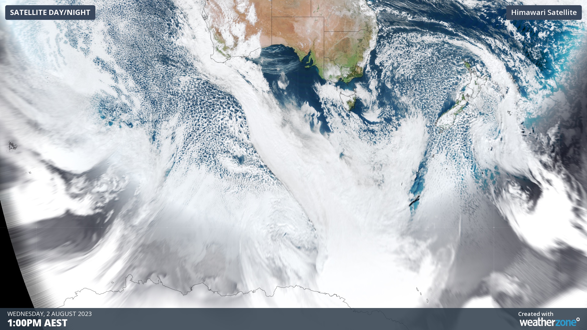
Impressively, the colossal band of cloud associated with this cold front could be seen stretching around 4,000 km from WA to Antarctica on Wednesday.

As the front moves further east today and tomorrow, it will run into a blocking high pressure system, causing it to be deflected to the south of Australia. This will help reduce the severity of its impacts, although some areas will still see strong and potentially damaging winds and heavy rain.
Northerly winds will strengthen over SA, Vic and Tas ahead of the approaching cold front and low pressure system.
The strongest winds in SA will be on Thursday. While gusts will remain below damaging strength for most of the state, isolated gusts reaching around 70 to 90 km/h are possible about the Mount Lofty Ranges and Kangaroo Island on Thursday.
Further east, wind will also pick in parts of Vic on Thursday, before a stronger surge of northerlies spread across Vic and Tas on Friday.
Damaging wind gusts are likely on the Vic ranges on Thursday and Friday, and in elevated and exposed coastal areas of Tas on Friday. As of midday AEST on Thursday, a severe weather warning was already in place for parts of Vic.
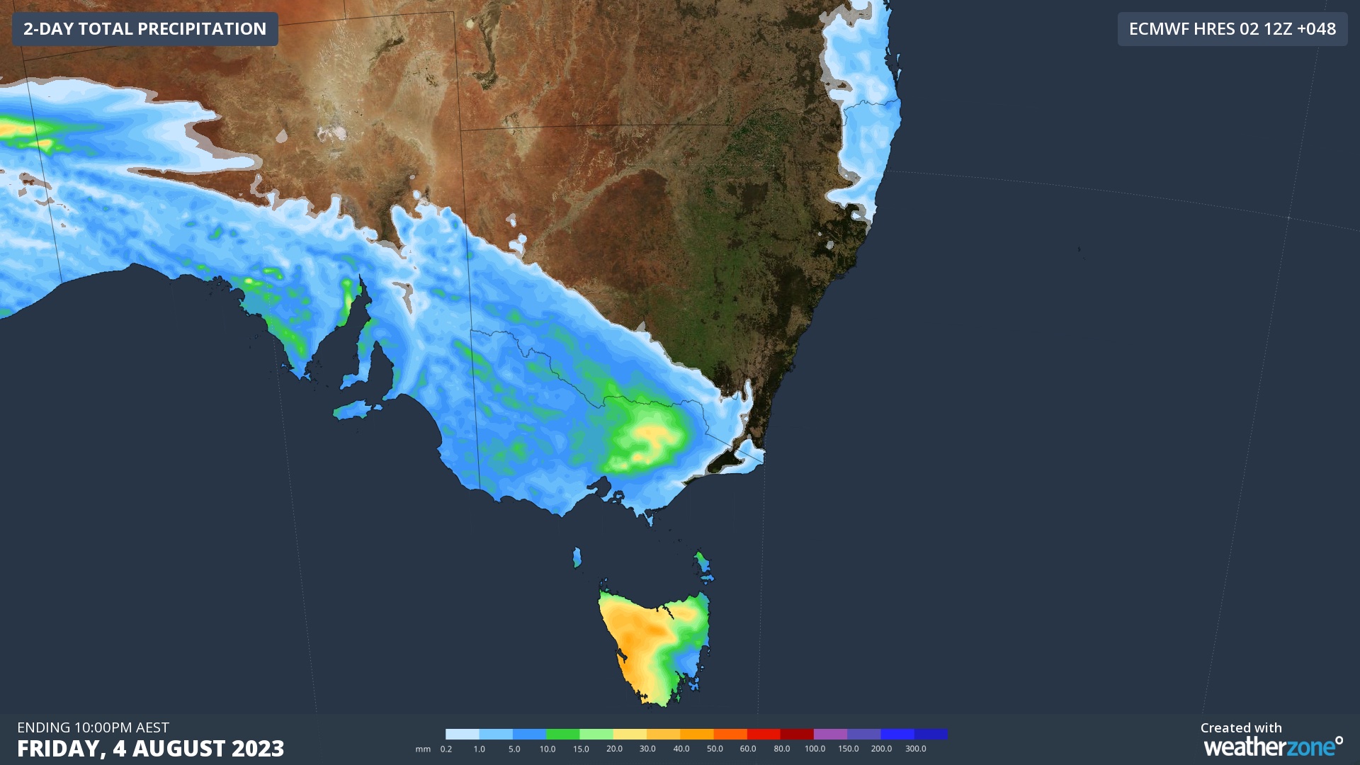
As the cold front marches across southern Australia, it will also drag a rainband across southern SA, Vic, Tas and NSW during the next 48 hours.
The map below shows the highest falls in the next couple of days are expected across southern SA, Tas, Vic and southern NSW, in particular the alpine regions.

The coldest pool of air is expected to slip to the south of the continent, meaning Australia’s alpine region will see more rain than snow from this system. Rain will develop over the Alps on Friday afternoon and continue into the night, before some light snow on Saturday.
This rain will reduce the already dwindling alpine snowpack following an unusually warm and dry July.
Severe weather warnings are likely to be issued in parts of southeastern Australia over the next two days. Be sure to check the latest warnings for the most up-to-date information.