Stormy Weekend Ahead: severe thunderstorms to impact southeast Australia
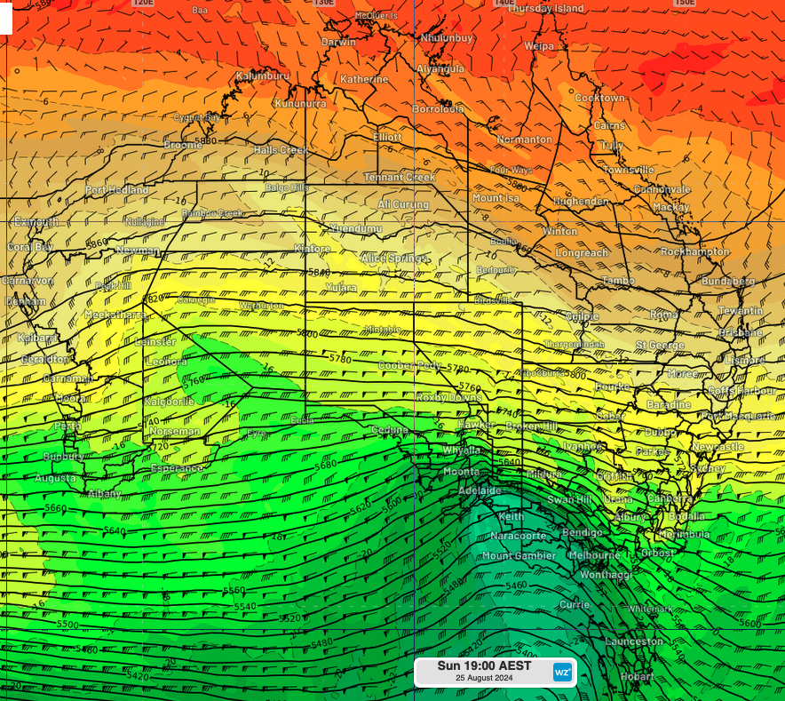
A stormy end to the weekend is set to impact southeast Australia with damaging/destructive winds, heavy rainfall, and large (potentially giant hail) as a pre-frontal trough moves through the region. This surface trough will be supported by strong upper-level winds, a sharp upper-level trough, and a pool cold air aloft (Fig. 1), all of which have the potential to support organised convection and the development of severe thunderstorms, most likely in the form of a squall line and supercells during tomorrow.

Fig 1. 500 hPa (~mid-atmosphere) Temperature, wind speed and direction (barbs) and geopotential height showing the strong upper-level winds, upper-level trough, and cold air aloft.
A squall line is a linear formation of thunderstorms that typically develops along or ahead of a cold front, often stretching for hundreds of kilometres. These storms can bring severe weather, including strong winds, heavy rain, and sometimes hail. Within a squall line, there can also be embedded supercells, making the squall line particularly dangerous. Let's take a closer look at supercells now.
What is a supercell?
A supercell is a type of intense and organised thunderstorm that features a rotating updraft. These storms are known for their ability to produce severe weather, including large hail, strong winds, and tornadoes. Supercells are more structured and long-lasting than typical thunderstorms, making them particularly hazardous and important to monitor for weather warnings.
The combination of strong upper-level winds, an upper-level trough, and cold air aloft this Sunday will create ideal conditions for supercell development over southeast Australia. Curious about how these factors work together? Keep reading to discover how these elements set the stage for severe weather.
The strong upper-level winds and the presence of an upper-level trough enhance the storm's rotation and maintain its structure by increasing wind shear (the change in wind speed and direction with height in the atmosphere) and atmospheric lift, both of which promotes organisation and longevity, by constantly moving the updraft away, keeping it separate from the stabilising cold air in the downdraft. Meanwhile, the temperature contrast between the cooler air aloft and the warmer surface air increases atmospheric instability by boosting the buoyancy of rising air parcels, resulting in more vigorous updrafts. These strong updrafts carry moisture high into the storm, where temperatures are below freezing, leading to the formation and growth of hailstones. The prolonged exposure to these strong updrafts causes the hailstones to grow larger before eventually falling to the ground.
What areas will be affected by the storms tomorrow?
On Sunday 25th and early Monday 26th, severe scattered thunderstorms will impact southeast SA, VIC, western parts of the ACT and southern and eastern NSW. As the trough advances eastward, it will strengthen, leading to possible widespread storms over VIC. Melbourne will also be affected by these severe storms, which could cause flight delays on Sunday afternoon and evening.
Some models suggest that supercells may become organised enough to produce areas of giant hail, most likely over northern VIC (including parts of North Country, Central, North Central, Mallee, and North East) and southern NSW (Riverina).
For the latest updates, visit our website tomorrow. Stay safe and take care if you're in the affected areas.