Storms and a soaking over NSW, Qld
Nearly one million lightning strikes flashed over NSW and Qld skies on Saturday and Sunday morning, while record November rain has fallen along the coast.
Video: Lightning strikes, radar and satellite showing the rain and storms over Australia on Saturday and Sunday morning.
Around 940,000 lightning strikes were detected by the Weatherzone Total Lightning Network over NSW and Qld from midnight Saturday to 9am on Sunday, with thunderstorms stretching from Far North Qld to central NSW. Combined with storms over WA and the NT, Australia has already seen over 1.3 million lightning flashes so far this weekend.
Roma was hit by a particularly intense thunderstorm at 2:30pm Saturday. A downburst over the town caused a powerful 104km/h wind gust, its strongest wind gust for 10 years, as well as 4cm (golf-ball sized) hailstones.
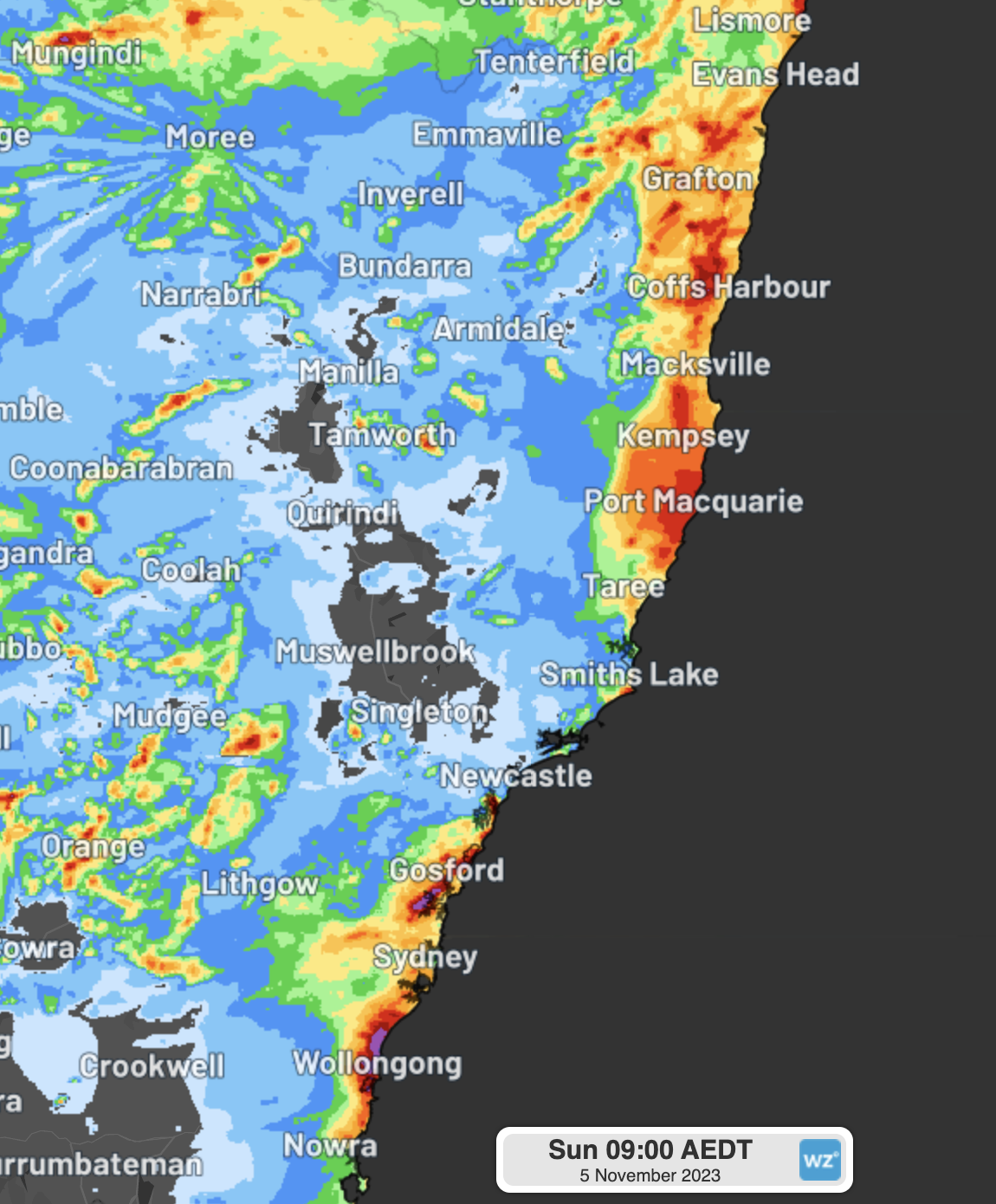
Over the east coast, several slow-moving thunderstorms pushed in from the ocean to deliver a widespread 30-60mm from the Illawarra up to the Qld border.

Image: Estimated observed rainfall in the 24hrs to 9am Sunday from DTN’s Metstorm
Bellambi recorded the heaviest rain in the state, with a localised thunderstorm delivering a mammoth 155mm, its wettest November day in 26 years of records, and the most in a day since last year's East Coast Low in July.
Evans Head was also on the receiving end of a slow-moving thunderstorm, delivering 120mm, its wettest November day in 25 years of records, and its wettest day since the ‘Lismore Floods’ in March 2022. Most of that rainfall fell in just a 2-hour period between 9pm and 11pm.
Heavy bursts of rainfall also fell on recent fire grounds. Kempsey recorded 64mm, its wettest November day in 14 years, helping to supress several blazes in the area that had been burning at emergency level a few weeks earlier.
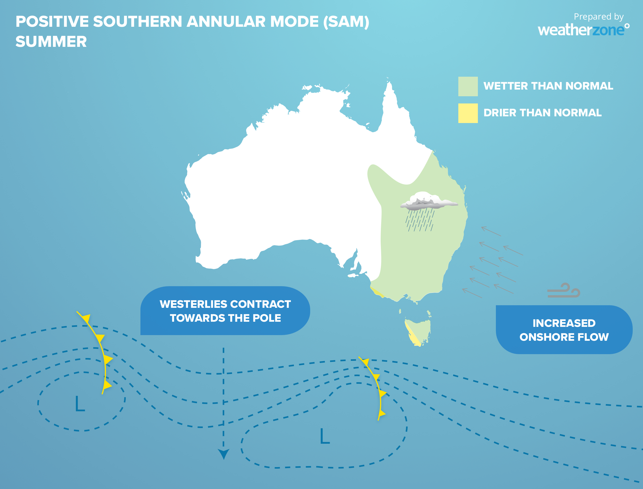
This sudden shift in the weather is due to a recent strong positive phase of the Southern Annular Mode (SAM). During a positive phase, cold fronts shift further south, allowing easterly winds to feed moisture over the east coast (see diagram below). In 2022, the SAM was consistently positive, and was one of the major contributors as to why 2022 was so wet in the east.

Over the last few months, the SAM has been negative, as is common in El Niño years, which increases dry westerly winds over eastern Australia, explaining the increased bushfire activity both Qld and NSW have seen over the last few months. This positive SAM phase is expected to be longer than previous bursts this year, but some models are suggesting a return to neutral or negative conditions in about a fortnights time.
In the meantime, this rain and thunderstorm activity is far from done. Models show coastal showers and inland thunderstorms each day of the forecast for at least the next 7 days over NSW and southern Qld and will likely spread into eastern Vic as well. Stay tuned to the latest updates, forecasts and weather warnings at Weatherzone.com.au.