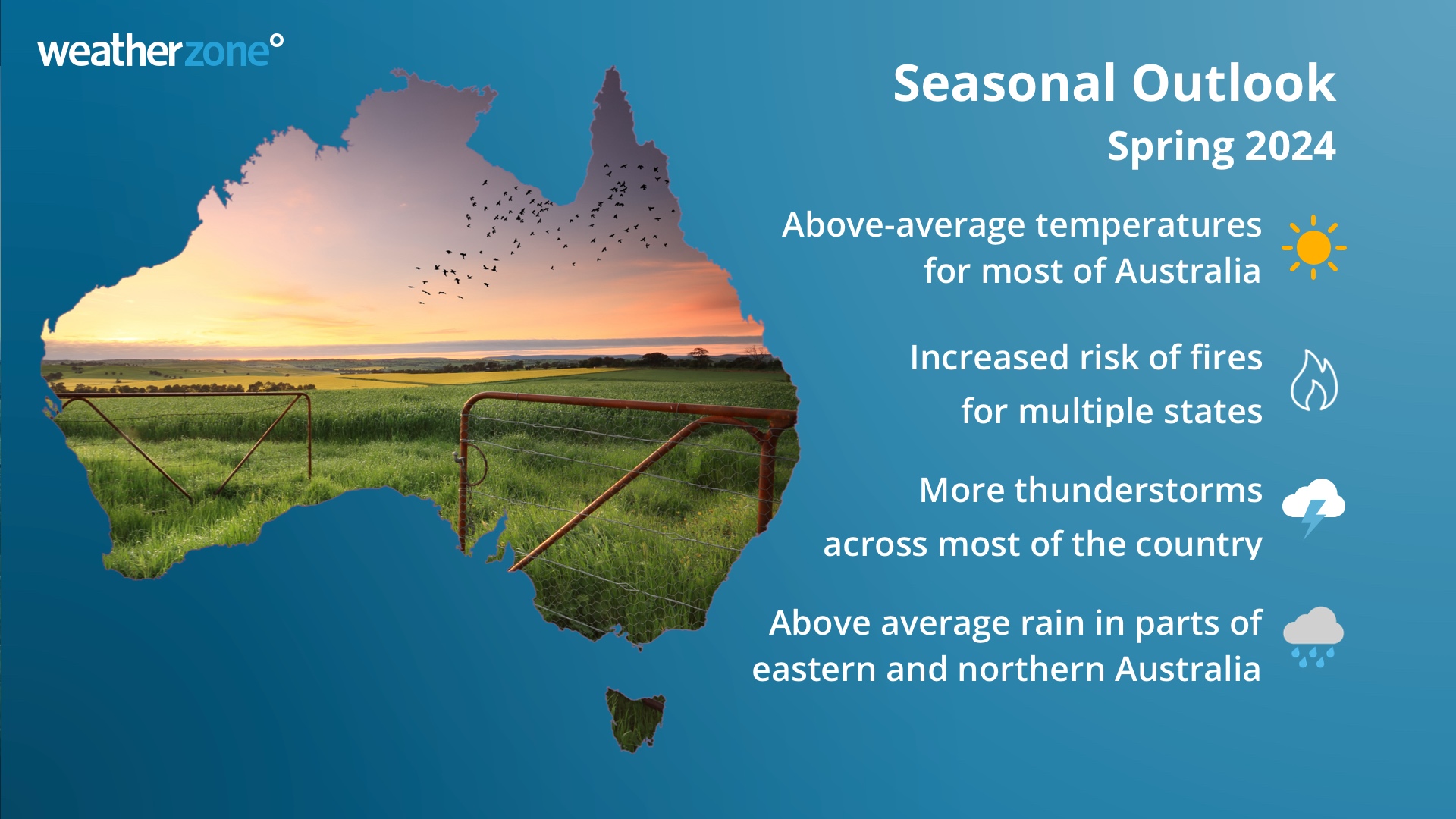
Spring 2024 outlook for Australia: warm and stormy season with increased fire risk
This spring is shaping up to be an unusually warm and stormy season for Australia, with some parts of the country also likely to see an increased risk of fires.
Australia has entered spring off the back of its warmest August and second warmest winter on record. The end of winter was also very dry for large areas of southern Australia.
So, what can we expect to see across Australia this spring and what are the main drivers behind this outlook?
Climate drivers this season
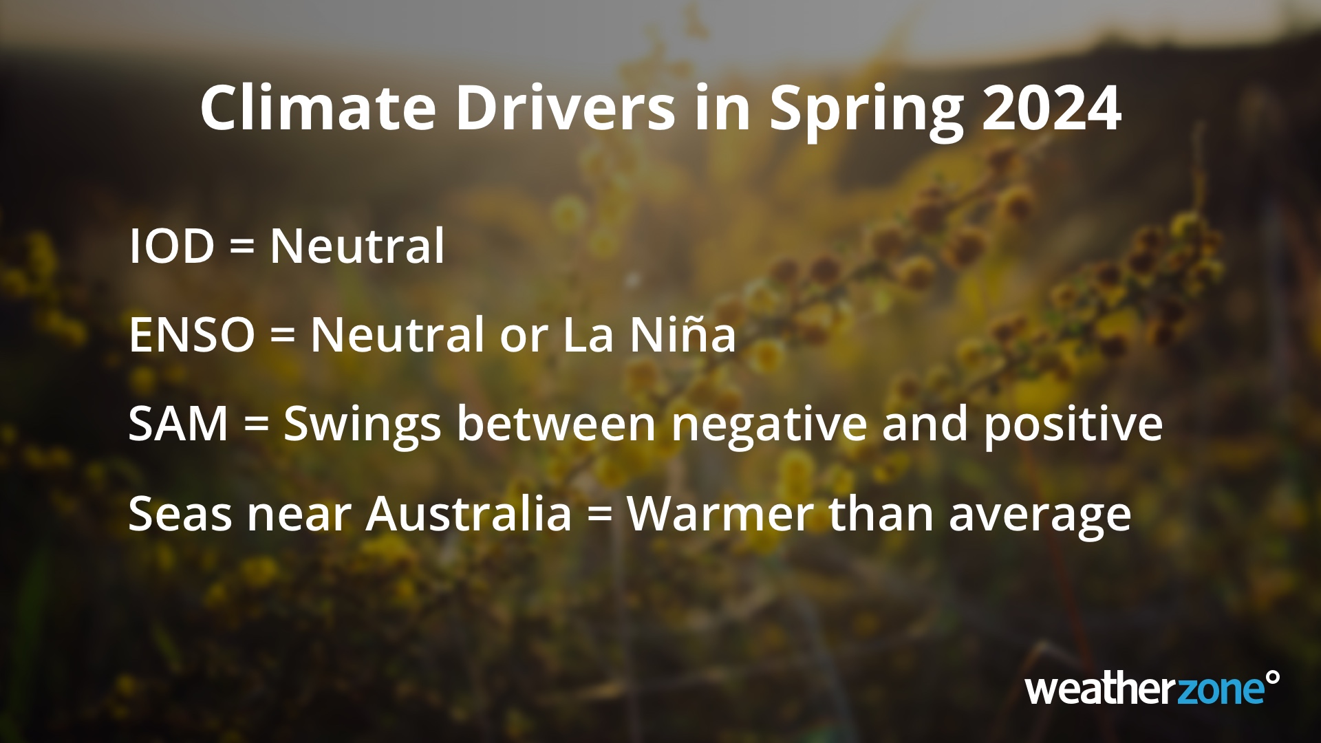
There are three main climate drivers that influence Australia’s weather on a seasonal scale. These are the El Niño-Southern Oscillation (ENSO) in the Pacific Ocean, the Indian Ocean Dipole (IOD) in the Indian Ocean, and the Southern Annular Mode (SAM) in the Southern Ocean.
In addition to these primary climate drivers, Australia’s weather is also influenced by sea surface temperatures around the country and the background forcing from climate change.
Australia has entered spring with no primary climate drivers strongly influencing weather patterns across the country. The Pacific Ocean and Indian Oceans are currently in neutral phases and while Southern Annular Mode (SAM) was negative for parts of July and August, it returned to a neutral phase before the beginning of September.
Pacific Ocean (El Niño-Southern Oscillation)
The Pacific Ocean is currently in a neutral phase. However, some cooler-than-average water has emerged at the surface of the equatorial Pacific Ocean in the last few months and this cooling may be a sign that La Niña is developing in the Pacific Ocean.
Computer models suggest that this La Niña-like pattern may continue to mature in the coming months, with potential for a La Niña event to become established towards the end of spring or in summer.
If La Niña does form, it would increase the likelihood of rain and thunderstorms over parts of Australia this spring.
Indian Ocean (Indian Ocean Dipole)
The Indian Ocean is currently in a neutral phase. All forecast models suggest the IOD will remain neutral this spring and should not have any influence on Australia’s weather throughout the season.
Southern Ocean (Southern Annular Mode)
The SAM entered a strong negative phase in late July and much of August in response to two phases of rapid warming in the polar stratosphere above Antarctica. This negative SAM returned to a neutral phase by the start of September, however there are signs that we could see further stratospheric warming above Antarctica in the coming weeks. If this stratospheric warming does occur, it will increase the likelihood of further negative SAM phases this spring, particularly in the first half of the season. However, if the stratospheric influence wanes, a neutral-to-positive SAM will be more likely this season.
Late-spring and early summer will most likely see a return to positive SAM under the influence of a potential La Niña and the lingering stratospheric moisture associated with the Hunga Tonga–Hunga Ha'apai volcanic eruption in 2022.
When the SAM is in a negative phase, westerly winds and the cold fronts and low pressure systems they carry are located further north than usual for that time of year. When the SAM is positive, the westerly winds, cold fronts and low pressure systems are located further south than usual for that time of year.
Negative SAM events in spring are typically associated with reduced rainfall in eastern Australia and more rain in parts of far southern Australia. Conversely, a positive SAM in summer usually increases rainfall over eastern Australia and causes drier conditions in the far south.
Sea surface temperatures
In addition to the primary climate drivers listed above, Australia’s weather this spring will also be influenced by warmer-than-average sea surface temperatures surrounding most of the country. These warm waters will enhance evaporation and add extra moisture into the atmosphere, which will help fuel rain and thunderstorm in some parts of the country.
Australia's spring weather is also being influenced by the background warming trend of climate change. The national mean air temperature during spring has increased by 1.71°C since 1910, while oceans surrounding Australia have warmed by 0.7°C in the same period.
Temperature Outlook
Australia has entered spring off the back of its warmest August on record. This warm end to winter has laid the foundations for heat to build further in the opening weeks of spring, particularly over central and northern Australia.
If negative SAM phases develop in the first half of spring, westerly winds could transport this warm and dry inland air towards the south and east of the country. However, during late spring and summer, days may become cooler than average in eastern and northern Australia if positive SAM phases and La Niña develops.
Minimum temperatures are expected to be above average across most of Australia this spring, under the influence of the unusually warm sea surface temperatures surrounding Australia and the potential for increased cloud cover late in the season.
Rainfall
Near average rainfall is forecast across large parts of Australia during the first half of spring. However, wetter-than-average conditions could develop over eastern and northern parts of the country in the second half of spring under the influence of a potential La Niña, warm sea surface temperatures and positive SAM.
If La Niña develops, this will increase the risk of heavy rain and flooding across parts of eastern Australia, particularly areas that entered spring with a wet landscape from above average winter rainfall.
Thunderstorms
Thunderstorm activity starts to increase in Australia during spring as rising temperatures and increasing atmospheric moisture and instability provide the key ingredients for storm development.
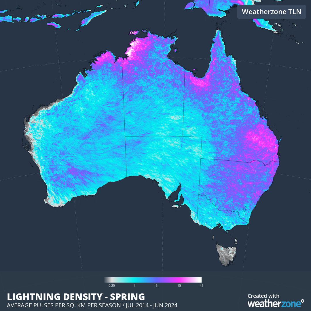
Image: Average lightning density in spring based on lightning detected over Australia during each spring from 2014 to 2023.
This spring will most likely begin with a typical amount of thunderstorm activity due to a lack of any strong climate driver influence. However, increasing temperatures and atmospheric moisture could see storm activity trending above average in mid-to-late spring.
If negative SAM phases occur in the first half of winter, there will be an enhanced risk of damaging winds and large hail in thunderstorms due to increased wind shear. Then, if La Niña emerges in late spring or summer, the risk of heavy rainfall and flooding would become an increased risk with thunderstorms.
Bushfires
Australia’s warmest August on record has laid the foundations for an increased risk of fires in multiple states and territories this spring.
The map below shows the official Australian Seasonal Bushfire Outlook from AFAC. The red shading on the map shows areas that have an increased risk of fires over the next three months. The remaining grey areas on the map have a near-normal risk of spring fires.
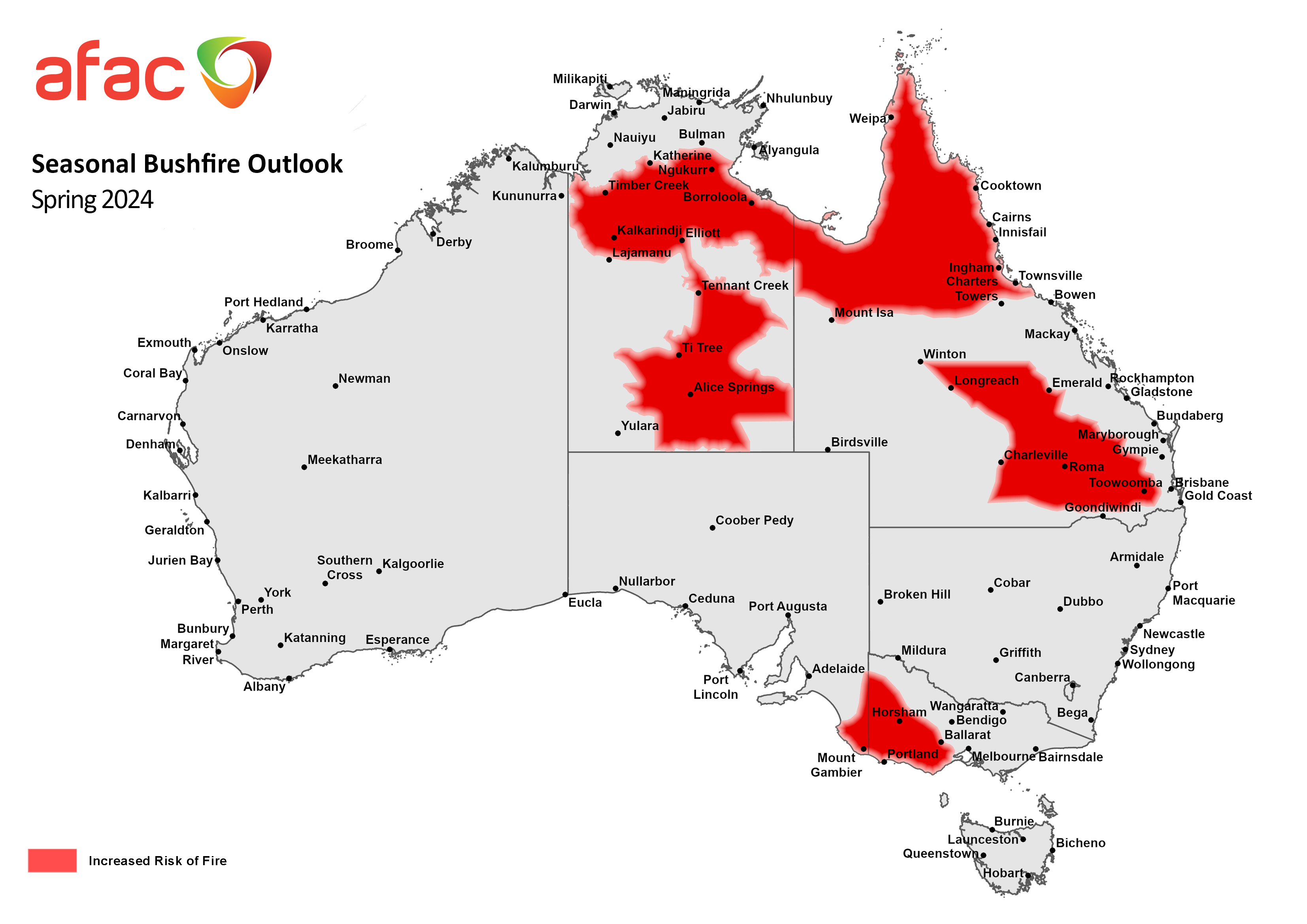
Image: Australian Seasonal Bushfire Outlook for spring 2024. Source: AFAC
Large areas of the NT and Qld, and parts of southeastern SA and western Vic are expected to see an increased risk of fires in spring. In the NT and Qld, this increased fire risk is a result of:
- Healthy rainfall earlier this year and in previous years, which has enhanced vegetation growth
- Abnormally hot and windy weather towards the end of winter, which amplified vegetation curing
- Forecast above average temperatures in the coming months
In southern Australia, parts of SA, Vic, Tas and WA experienced record low rainfall during the first half of this year. While above-average rain returned to parts of southwest WA and Tas during August, parts of Vic and SA continued to see abnormally dry weather through late-winter. This ongoing dryness in SA and Vic is depleting soil moisture and enhancing vegetation dryness, with AFAC predicting an increased the risk of fires in western Vic and southeast SA this spring.
It’s also important to note that the near-normal fire risk predicted for large areas of eastern and southeastern Australia this spring is partially linked to an expectation of above-average rainfall during the next few months. If this wetter-than-average weather does not eventuate, the risk of fires will also be higher than normal.
NSW is one state that has a notable risk of fires if above average rain doesn’t occur this season, particularly in the second half of spring. The AFAC outlook notes that “grass fuel loads remain higher than normal due to favourable growing conditions.”