
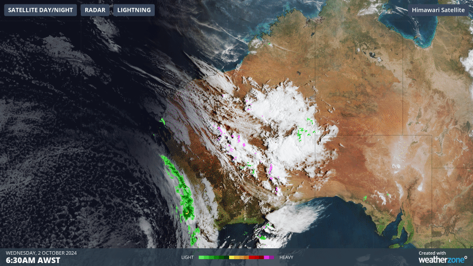
Speckle-tacular cloud field as Perth pelted
A strong cold front has crossed southwest WA early on Wednesday morning, sending temperatures plummeting and delivering widespread rainfall totals in the 10 to 25mm range.
- Perth received 16mm of rain in a four-hour burst between 5:30am and 9:30 (AWST) with further showers likely throughout Wednesday and the coming days.
- At least two stations in the Margaret River area in the South West forecast district topped 20mm in the 24 hours to 9am Wednesday.
- Handy falls were also recorded further north in the Central West forecast district, with two stations near Geraldton recording 16 mm while "Gero" itself recorded 7.6mm.
The useful rainfall totals across the southwest were accompanied by a surge of cold air.
- At midnight, Perth was 17.1°C.
- By 9am, it was a chilly 12.3°C as winds had shifted from the northwest to the southwest behind the cold front, which you can see making landfall around dawn in the loop above.
Behind the front was a classic field of speckled cloud, which always indicates cold air impacting southern Australia.
- Speckled cloud fields form when very cold air moves over a relatively warm area of ocean, causing a large number of individual cumulus clouds to develop over a broad area.
- Each of these cloud cells can produce rain, hail, snow (at higher elevations) and thunderstorms, with patches of clear sky in between.
While the main cloudband associated with the cold front is now tracking across the WA wheatbelt, that speckled cloud field behind it will ensure showers for the next few days in Perth and most of southwest WA, gradually decreasing in frequency as the week progresses.
This rain is good news for the region.
Perth endured its driest 7-month spell on record up until May this year. Late autumn and winter then delivered a much-needed soaking, but September saw only about half the average monthly rainfall.
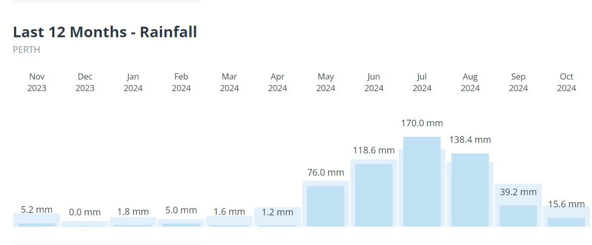
Image: Running 12-month rainfall graph for Perth from November 2023 to October 2024.
Any wet weather before the inevitable drying out over summer is still very welcome.
In addition to the rain, storms and cold airmass, this system is bringing unusually windy conditions to parts of southern WA. Widespread damaging winds are likely to develop across the South West, Lower West including Perth, South Coastal, Great Southern, parts of the Central Wheat Belt, Goldfields, South East Coastal and Central West from late this evening, easing by Thursday afternoon. According to BOM's warning issued at 10:45am local, "Locally destructive winds of around 125 km/h are possible along the coastal fringe between Bunbury and Augusta, easing early Thursday morning."
They also warned that seperate Severe Thunderstorm Warnings will be issued if very dangerous thunderstorms with destructive wind gusts are detected. The very strong winds will also whip up damaging surf conditions along an extensive coastline along the southwest between Kalbarri and just south of Walpole from late Wednesday afternoon, before easing by Thursday evening.
Please keep an eye out for the latest warnings as today unfolds.