
South Australia's hottest February day on record
The outback South Australian town of Oodnadatta has registered the state's hottest February day on record this Wednesday, with the mercury reaching a sizzling 48.7°C at 3:15pm. The previous February state record was 47.2°C.
Many remote SA spots recorded temperatures almost as hot as Oodnadatta, with Coober Pedy reaching 48.1°C and Tarcoola not much cooler at 47.8°C.
Meanwhile Adelaide reached its highest temperature in more than five years when when the mercury soared to 43.3°C and and topped 44°C in some suburbs
- Adelaide's maximum of 43.3°C came relatively late in the day at 5:11pm. The last day to get so hot was Jan 30, 2020, when the mercury also reached 43.3°C.
- February 2025 has been an exceptionally hot month to date in Adelaide, with a running average maximum of 34.9°C to 3pm this Wednesday, February 12. That's a whopping 6.4°C above the long-term February average of 28.5°C.
- December maximums were 2°C above average, while January maximums were 2.2°C above average so this really has been a sizzling Adelaide summer.
The good news for Adelaide locals is that temperature relief is on the short-term horizon. Significant rain, however, is not.
After a cold front arrives later this evening, Adelaide maximums will dip back to the twenties from Thursday through to at least next Tuesday – including a rather cool maximum of just 22°C for Saturday.
While the cooler temperatures will be welcome, if you talk to Adelaide locals and people pretty much anywhere in South Australia, the lack of rain is bothering them more than the heat.
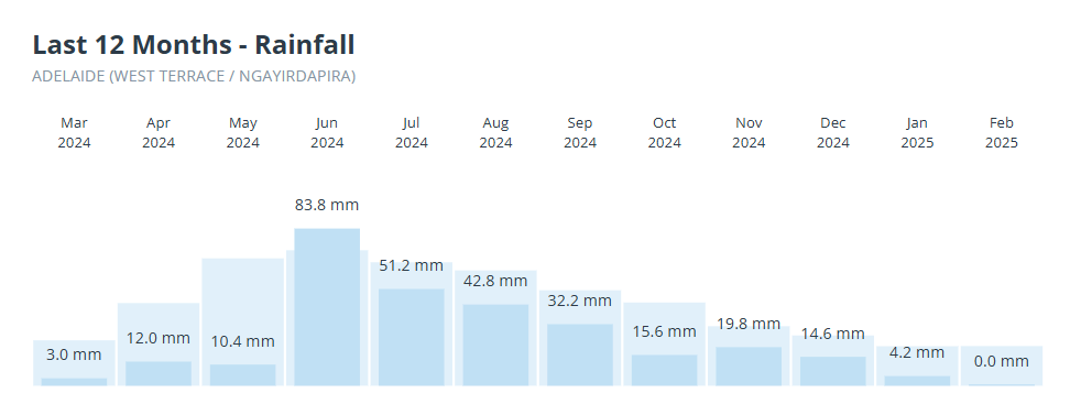
Image: Adelaide rainfall over 12 months from March 2024 to February 2020 (Feb figure is month to date).
There are many ways to illustrate Adelaide’s recent rainfall deficiency, including the chart above (which you can find on our Adelaide weather page) which shows that 11 out of the last 12 months have seen below-average rainfall – and the above-average month wasn’t by much.
Another take on the data in our chart is the chart below from the BoM, which shows the rainfall deficiencies over a similar period, in this case Feb 2024 to Jan 2025.
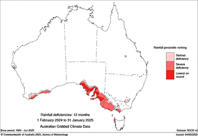
Image: Rainfall deficiencies since February 2024. Source: BoM.
As you can see, a large area covering all of southeastern SA and southwestern Vic has suffered severe rainfall deficiencies or even the lowest rainfall totals on record.
Then there are Adelaide's water storage levels which are currently at 41% compared to 62% this time last year.
Any way you look at it, Adelaide – and areas within several hundred kilometres of the SA capital – have been desperately dry for at least 12 months now.
For those looking for an end to the dry trend, the BoM’s most recent climate outlook, issued on February 6, states that "rainfall is likely to be within the typical range for the season for much of southern Australia" for the period from March to May.
While that doesn't rule out a nice soggy autumn for parched parts of SA and Vic, it doesn't point to it with any confidence either.