Should I go to the snow this weekend (Covid permitting)?
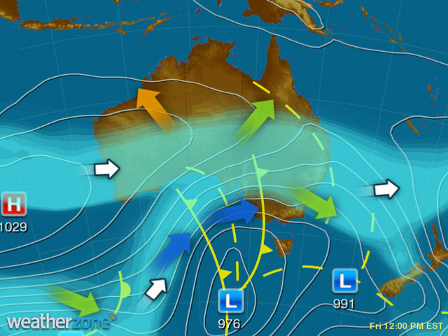
Bring it on: the Friday 12 pm synoptic chart is one of the most exciting charts of the season from a snow lover's perspective.
But before we dissect what makes it such a good set-up for snow on the mountains of New South Wales and Victoria, here's a Covid reminder/empathiser:
Weatherzone understands that many people are unable to make it to the snowfields this weekend due to the snap lockdown in the whole of Victoria and the ongoing lockdown in greater Sydney and surrounds.
We know that the Covid situation frustrates you, as it does us, and we present this story as information to those in regional NSW and further afield who are lucky enough to be free to travel, and as a kind of "we wish" for the rest of us. It doesn't hurt to dream about the snow! Thank you.

So here's what makes the chart above so ideal for snowfalls on the mountains of the mainland:
- A cold front and low pressure trough can be seen in the centre of the chart, one in the Bight approaching South Australia, the other already over western Victoria.
- The front and trough are being driven by a large low pressure system south of the mainland which will drag cold air and moisture up from the Southern Ocean over southeastern Australia from Friday through to Sunday.
- Ahead of the trough currently over western Victoria, a vigorous west-northwesterly airstream is being lifted up the mountains, cooling and condensing as as the air rises. This lifting is condusive to precipitation.
- The air is already nice and cool in the wake of a trough which passed through southeast Australia this morning.
- Crucially, there is plenty of moisture in this system. In an absolutely perfect world, a system like this could have even more moisture with a feed of moist Indian Ocean air. That sort of set-up is when you get rare dumps of a metre of snow or more in Australia. But this system is still likely to deliver around 60 cm or more in some places by late Sunday, starting now.
And the result?
Snow, and lots of it, is on the way. In fact it is already falling.
Image: They've already had a "foot" of snow at Perisher. Source: @Perisher_resort on Instagram.
NSW
By the middle of next week, close to 100% of all ski terrain should be open in all NSW ski resorts. NSW currently has a deeeper snowpack than Victoria, due to falls earlier in the season which Victoria missed out on.
Before the snowfalls that started today, the official Snowy Hydro snow depth was 63.7 at Spencers Creek, about halfway betwen Perisher and Thredbo, as measured by Snowy Hydro.
That should mean well over a metre of depth by midweek next week after these snowfalls have compacted, and a metre-plus base usually means all systems go at Perisher, Charlotte Pass and Thredbo.
View this post on Instagram
VICTORIA
At last, Victoria should have a large chunk of its terrain open for skiing and snowboarding after this dump.
Falls Creek and Mt Hotham in the northern part of the VIC Alps have been trundling along OK so far this season with about half their lifts open in recent weeks, but things have been pretty dire at Mt Buller and Mt Baw Baw in the south.
But no more! All resorts should be close to fully operational if this system delivers as hoped.
View this post on Instagram
IN SUMMARY...
If you can go skiing this weekend, it'll be the best snow of the season, even if the weather will be extremely wild and woolly with the strong likelihood of some lifts on wind hold as extreme weather lashes four states.
But this system should set up the eason, and if the Covid situation eases, snow lovers will be in for a treat in coming weeks.