
Severe weather as cold front lashes SE Aus
An active cold front is crossing southeastern Australia, with severe weather warnings for damaging winds issued early on Thursday morning for parts of Victoria and NSW.
The front was preceded overnight by a band of rain which crossed southern parts of SA, northern and western Tas, and the western half of Vic.
- Totals of up to 10 mm were registered in many locations, with slightly higher totals between 10 and 20 mm in the Adelaide Hills and NW Tasmania.
- Melbourne has only received a couple of millimetres in most suburbs, which is a fairly typical result for a winter system like this where winds and moisture are coming out of the north, but heavier showers can be expected on Saturday as winds turn westerly with the arrival of a second front.
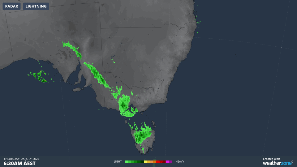
Meanwhile the band of showers continues its eastward march accompanied by gusty winds that are reaching gale force in mountain districts.
Wind gusts have already exceeded 100 km/h at Mt William in The Grampians in western Vic, as well as the Victorian alpine weather stations of Mt Buller and Mt Hotham in the early hours of the morning, while Thredbo Top Station in NSW saw a gust of 115 km/h just after 10 am.
A wild storm went through early last night.
— Shayne Calliss (@SCalliss) July 24, 2024
Smashed a few things but everyone is fine pic.twitter.com/QnsfdEaPpo
Another factor making life unpleasant in the high country this Thursday is the temperature.
Last week we told you that the "feels like" temp dipped below –20°C at Thredbo Top Station, and it has already nudged the –20°C mark today.
But the actual air temperature (the still air temp) is slightly above zero, meaning the mountains are seeing a mixture of rain and wet snow at higher elevations.
As cooler air sets in behind the front, the snow line should drop to around 1400m, which is around the base level of our lowest resorts. Around five to ten cm of fresh snow could accumulate by Friday morning. As ever, check our snow page for the latest.
A similar amount of snow could again settle by Sunday morning, but the difference with the second front coming this weekend is that it will usher in significantly colder air.
Over the weekend, the snow line in Vic, NSW and the ACT could drop as low as 600 to 700 metres, while in southern Tasmania, snow could fall to the 400 metre level.
But for now, the weather is all about the front crossing the southeast this Thursday with its showers, strong winds, and significant temperature differentials.
At 10:30 am, Sydney was 19.6°C in the warm air ahead of the front while Melbourne was a chilly 11.1°C (which felt much colder under strong northwesterlies).
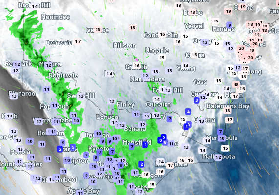
Image: Temps around 11 am in SE Australia with Sydney basking in 20°C or thereabouts and Melbourne shivering in 10 degrees or so.
Sydney tends to be well protected from all but the strongest fronts out of the west and northwest, and is expected to see max temps of 20°C or higher for the next few days. That'll change on Sunday as cold air arrives with the stronger front, wiping a good five degrees or more off maximum temps.