Severe storm warning as Sydney rain set in for the afternoon
It's turning into quite a treacherous Tuesday afternoon in Sydney, with steady rain across the city which is extremely heavy at times in some suburbs.
The Bureau of Meteorology issued a severe thunderstorm warning for Sydney at 2:14 pm that read:
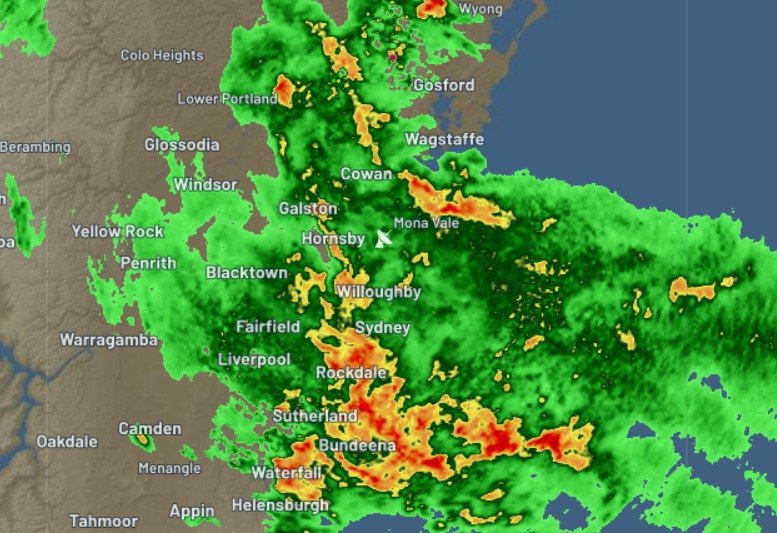
Severe thunderstorms were detected on the weather radar near Parramatta, Sutherland, Sydney City, Sydney Airport, Sydney Olympic Park and the Sydney Harbour Bridge.
They are forecast to affect Hornsby, Liverpool and Helensburgh by 2:40 pm and Richmond, Windsor and Campbelltown by 3:10 pm.
Intense rainfall that may lead to dangerous and life-threatening flash flooding and damaging winds are likely.
A road weather alert for flooded roads and reduced visibility in heavy rain for all suburbs was issued shortly afterwards.
Sydney rain is torrential right now. Roads moving super slowly, crazy. #sydney pic.twitter.com/5YINQbIqZ8
— Chriso (@ChrisoChindilas) February 22, 2022
Why so wet in Sydney today after less than 1 mm in total over the past eight days?
Tuesday was always going to be a wet one, with a range of 20 to 40 mm of rain on the cards.
As Weatherzone meteorologist Ben Domensino wrote earlier today in his story titled "Stormy week ahead for eastern Australia":
"A stubborn high pressure ridge over the Tasman and Coral Seas will direct moisture-laden easterly winds across Queensland and NSW over the coming week. This airborne moisture would be enough to cause plenty of rain on its own. However, a broad upper-level trough passing over eastern Australia this week will help convert the moisture into heavy rain and dangerous thunderstorms."
The interaction between a trough and a moist onshore flow of air is what we're seeing in Sydney this afternoon.
By 2 pm as we started writing this story, rainfall totals had already comfortably exceeded this morning's predicted rainfall range in Sydney's Canterbury-Bankstown region, which is roughly 15-20 km southwest of the CBD.
- 50 mm had been recorded at Canterbury by 2 pm, mostly within the previous hour as storms struck that part of Sydney.
- 61 mm was recorded at Marrickville Golf Club in just one hour leading up to 2 pm.
- 65.2 mm had been recorded since 9 am at Bankstown, with the heaviest rain fall just before midday.
Other parts of the city had received falls closer to the 10-20 mm range, but as the 2:20 pm radar image shows, this rain is now set in across the city and looks likely to stick around for at least the next couple of hours.

Stay safe if you're in Sydney, and remember, we’ll be updating this story with severe storm and flood warnings as they are posted.