Rain, fierce winds end Sydney Big Bash showdown
We warned yesterday that wild weather could cause disruptions to the Big Bash showdown between the Sydney Sixers and Sydney Thunder at the SCG this Friday night.
It turns out that was a bit of an understatement.
Before the game could even begin, cricket fans in the Bill O’Reilly stand had to be evacuated when part of the stand’s roofing began to detach in fierce winds, eventually falling into the seating bays. No one was injured and, according to a statement from Venues NSW, cricket-goers were then provided with alternative seating in another grandstand.
But that wasn’t the end of the match’s woes.
After two rain delays, which saw staff battling against wild winds to keep the cricket pitch covers on, an official decision was made to call off the match entirely after only 5.1 overs.
The inclement weather, brought about by a low pressure system off the NSW coast, downed trees and power lines, leaving tens of thousands of people without power in the greater Sydney and Hunter regions for the second time this week.
Wind gusts of 90-110 km/h were recorded in and around Botany Bay yesterday afternoon and evening, including a 93 km/h gust at Sydney Airport and a 109 km/h gust at Molineux Point. Wind gusts of 85 km/h were recorded at Sydney Observatory Hill and Fort Denison. Gusty winds of around 100 km/h were also observed between the Illawarra and the Hunter yesterday, including gusts of 101 km/h at Murrurundi and 100 km/h at Bellambi and Norah Head.
Gusty conditions then continued over the Hunter into the small hours of Saturday morning, seeing 106 km/h gusts at Cabraburra and 94 km/h gusts at Nobbys Beach near Newcastle.
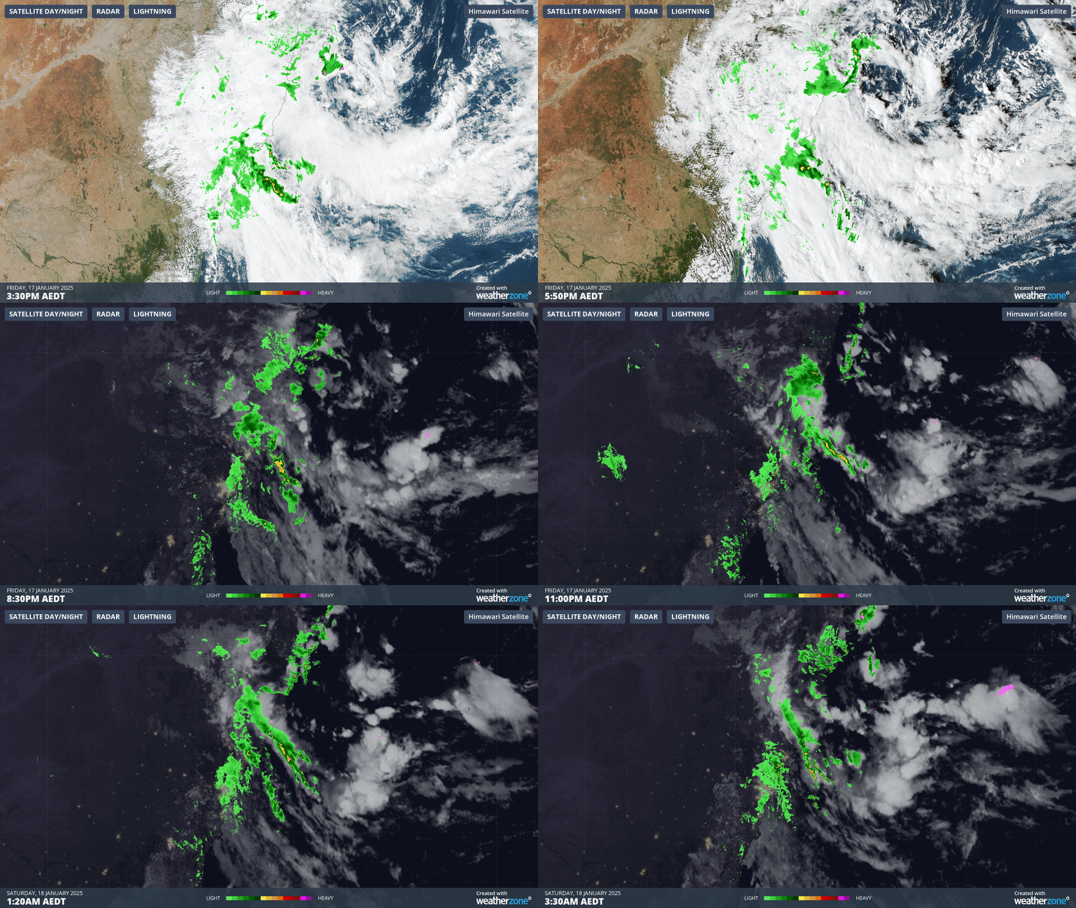
Rain also became intense over parts of the Hunter and the Mid North Coast on Friday night into early Saturday morning. In the gif below, you can see the swirling clouds indicating the approximate position of the low pressure system off the northern NSW coast in the afternoon, with cloud bands sending heavy rain over the Hunter region throughout the night.
 Image: 12-hour radar and satellite loop between mid-afternoon on Friday, 17 January, and the pre-dawn hours of Saturday, 18 January
Some notable observations include:
- 146 mm at Comboyne in the 6 hours to 2:07 am
- 116mm at Barrington Tops in the 6 hours to 2:40 am
- 90mm at Nabiac in the 3 hours to 2:06 am
Daily rainfall totals to 9am this morning were also some of the highest seen in January for several years in some areas, including:
- Mount Seaview (117 mm): wettest in 12 years, and also the wettest day of any month in almost three years
- Taree (79 mm) and Williamtown (66 mm): wettest in 9 years
- Scone (19mm): wettest in 3 years
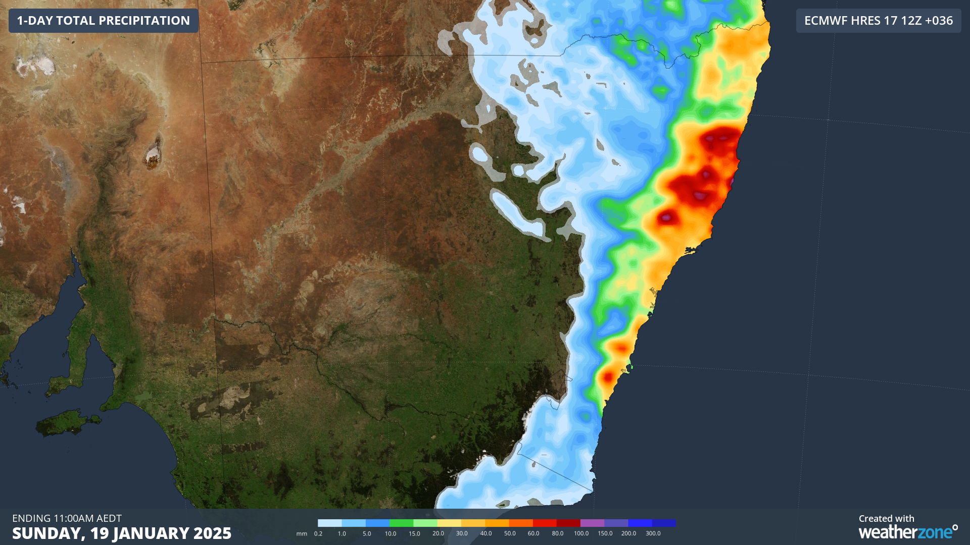
Heavy rainfall will shift north into Sunday, with some areas on the Mid North Coast already seeing rainfall in excess of 100mm since 9am this morning. This is consistent with forecast rainfall amounts into late morning Sunday, as seen below:
 Image: Accumulated rainfall to 11am AEDT on Sunday, January 19, according to the ECMWF model.
The good news is that the low pressure system responsible for all this wild weather is beginning to weaken and is expected to dissipate offshore tomorrow morning, just to the east of the NSW-Qld border, bringing welcome relief to those in eastern NSW.