
Perth's second warmest July on record
After parts of southwest Australia endured severe storms and ferocious winds in the past week, Perth has completed a hat-trick after experiencing its second-warmest July in records going back to 1944.
The Perth airport site had an average overall temperature of 14.5ºC during July, a whopping 1.4ºC higher than the 80-year average. Maximum temperatures themselves were the fifth highest on record (19.4ºC) and the warmest on average since 2020 (19.5ºC). Other locations in the region told a similar story:
- Bunbury had its third-warmest July since records began in 1996 (13.5ºC average temperature) and second-warmest average maximum temperature (18.1ºC).
- Albany had its warmest July since records began in 2012 (13.0ºC average temperature).
- Merredin, between Perth and Kalgoorlie, had its third-warmest July since records began in 1966 (12.5ºC average temperature).
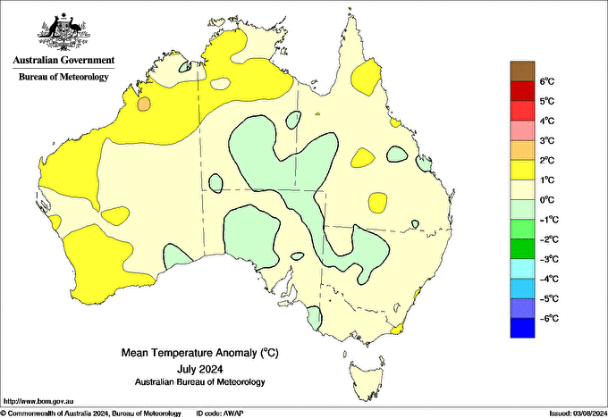
Figure: Mean temperature anomaly of July 2024 compared to the 1961-1990 baseline temperatures (Bureau of Meteorology).
As seen from the mean temperature anomaly map, the majority of Western Australia was 2-3ºC above the 1961-1990 average.
With winter being the wettest season across much of southwest Western Australia, it makes sense that moisture levels were elevated across the region. The figure below shows that the specific humidity anomalies were especially high for WA's Central Wheatbelt and surrounds. High humidity means dewpoints were elevated, hence the much warmer temperatures throughout July.
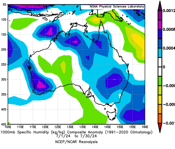
Figure: Near-surface specific humidity anomalies of July 2024 compared to the 1961-1990 baseline (NOAA Physical Sciences Laboratory).
This moisture came with the consequence of rainfall over the southwest, which we saw most recently in the final hours of July.
- Geraldton had its highest July rainfall in 12 years of records (157mm, average of 66.3mm)
- Bunbury had its wettest July since 2000 (232.0mm, average of 146.3mm)
Whilst August has started off close to average so far across the southwest in terms of temperatures, there are indications of increased warmth next weekend ahead of a potentially significant cold front.
Be sure to keep an eye on the latest forecasts and warnings on our website.