
Normally dry creek now 60 km wide
Creeks and rivers in southwest Queensland have spread across the landscape carrying floodwaters from last week’s heavy outback rain – with numerous moderate and major flood warnings in place.
The image at the top of this story shows rivers like the Diamantina, the Georgina, and Cooper Creek all in full flood, with waters flowing in a southwesterly direction towards the currently dry Kati Thanda- Lake Eyre Basin in South Australia. The waters will take several weeks to arrive.
Cooper Creek – the famous, usually dry watercourse along which explorers Burke and Wills perished of thirst and starvation in 1861 – is the easternmost of the waterways in the satellite image at the top of this story, with floodwaters approximately 60km wide at the broadest point.
READ MORE: Flood alerts stretch 3000km across Australia – more rain on the way
Below is a view of the landscape two weeks before last weel’s rain event, when most of the country pictured had barely received a drop of rain since the start of 2025.
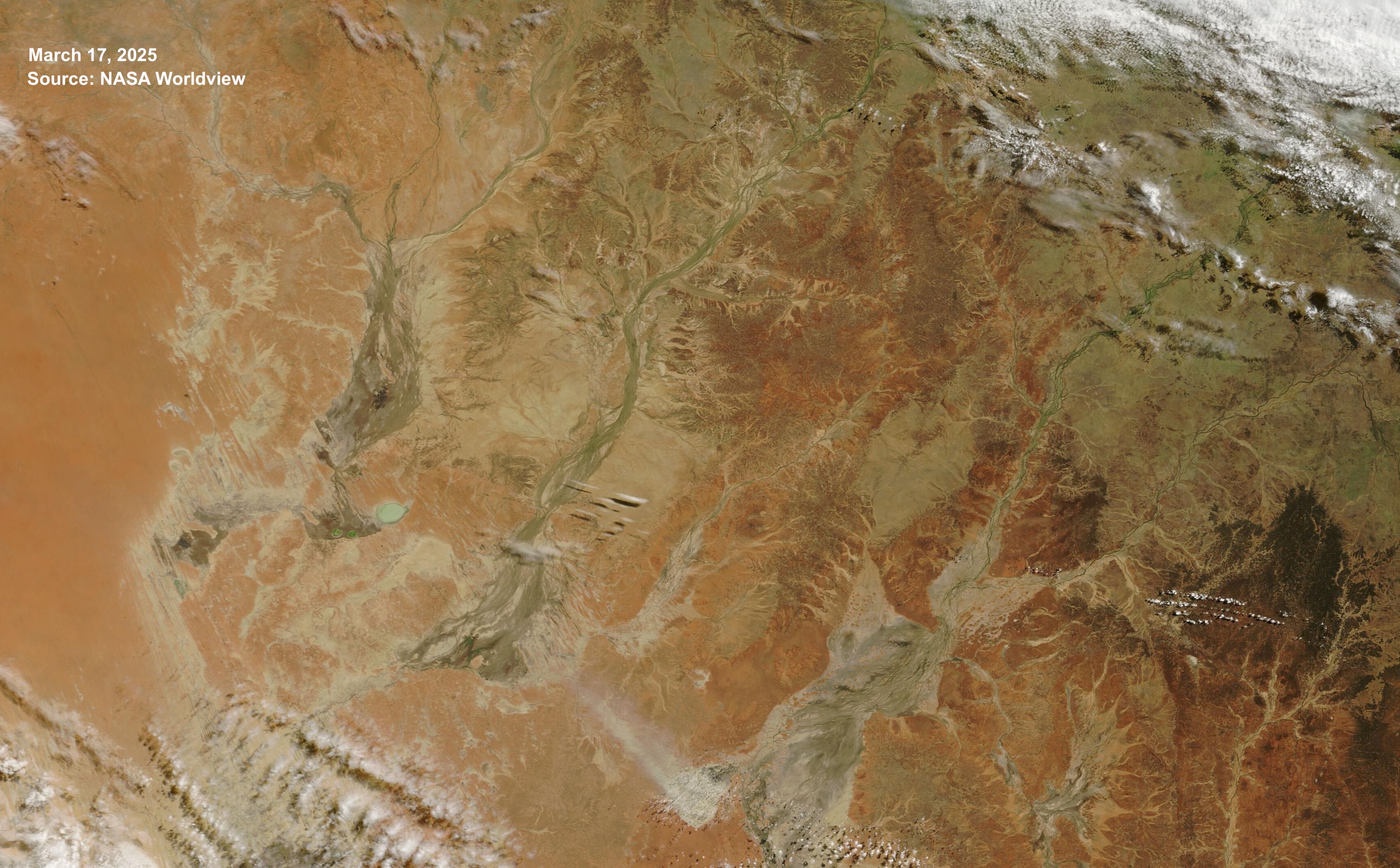
Image: Satellite image showing the dry landscape of far SW Queensland on Sunday, March 30, 2205. Source: NASA Worldview.
Here’s a slightly different view of the area after the rain. This satellite image captures a moment a little later on Sunday, March 30 than the image at the top of this story.
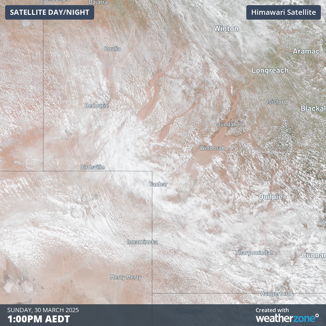
Image: Satellite image of SW Queensland and NE South Australia on Sunday, March 30, 2025.
A fascinating feature of the image is the thousands of tiny white dots. These are cumulus clouds formed by a combination of heat and moisture, as thermal air currents lift moist air from the surface as the day warms.
This part of the country would normally have a dry land surface which would hinder the formation of a large mass of cumulus clouds. But with all the recent rain, there is abundant surface moisture.
Note that there are no clouds over the flooded creeks and rivers. That’s because the air temperature is much lower over the water, and that's why the creeks and rivers stand out clearly on what is otherwise a relatively cloudy satellite image.
A reminder of how much rain fell
It takes a lot of rain to put so much water into outback waterways, and some of the totals last week were staggering, with too many records to mention.
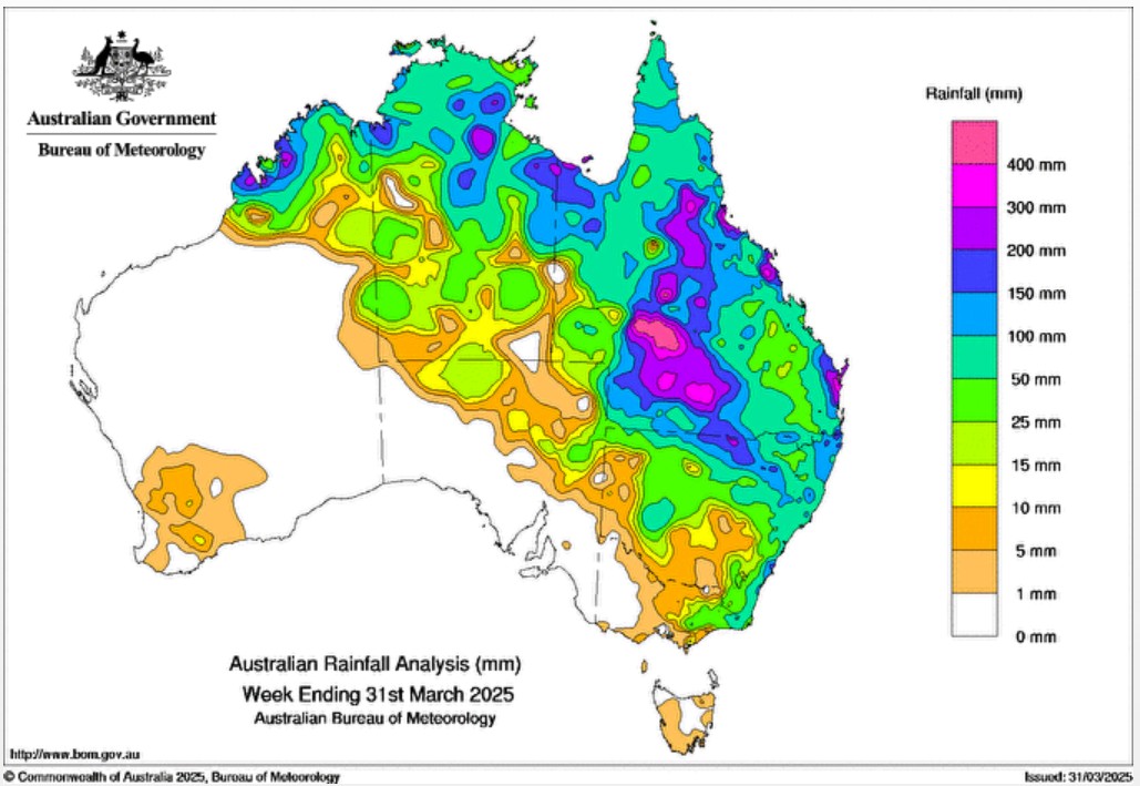
Image: Total rainfall for Australia in the week ending March 31, 2025. Source: BoM.
The map above provides an overview of last week’s rainfall across Australia. As you can see, huge parts of central and southwestern Queensland saw totals of 300mm or more.
Pockets of the Queensland coastline also saw those sorts of totals – and it’s not often that newsworthy rainfall figures in places like Mackay are equalled or even eclipsed by the amount that fell in locations as far as 1000km inland.
READ MORE: Record rain for iconic outback town
What happens to all that floodwater now?
In events like this, the water ends up in Kati Thanda-Lake Eyre – if it makes it without evaporating and seeping into the soil along the way – and in this case, there appears to be more than enough water to reach the normally dry salt lake.
Kati Thanda-Lake Eyre contains Australia’s lowest point at approximately 15 metres below sea level. It is an "endorheic" basin, which means it has no outflow.
If you’ve ever driven between Sydney and Canberra and seen Lake George (which has been full for most of the 2020s but has often been bone dry in recorded history), then you’ve seen another example of an endorheic basin, as Lake George also has no outflow.
When floodwaters fill Kati Thanda-Lake Eyre, it’s a bonanza for both wildlife and tourism. There’s even a Lake Eyre Yacht Club whose amusing motto is "Ya gotta be jokin' - No we're not!"
The club’s website says the water is expected to arrive in late April.