New Year’s Eve and Day: will you fry or soggify?
The end of the year is here, and revellers are finalising their New Year’s Eve tactics: where to go, how to get there, who to go with, will I need an umbrella, a jumper or an anti-melt device? We can help with the last three. Maybe tonight you’re going to curl up in the hermit safety of your loungeroom, away from festive social requirements, so you don’t care whether it’s going to rain. But do you need a blanket or a fan? A cold beer or pot of tea? Read on.
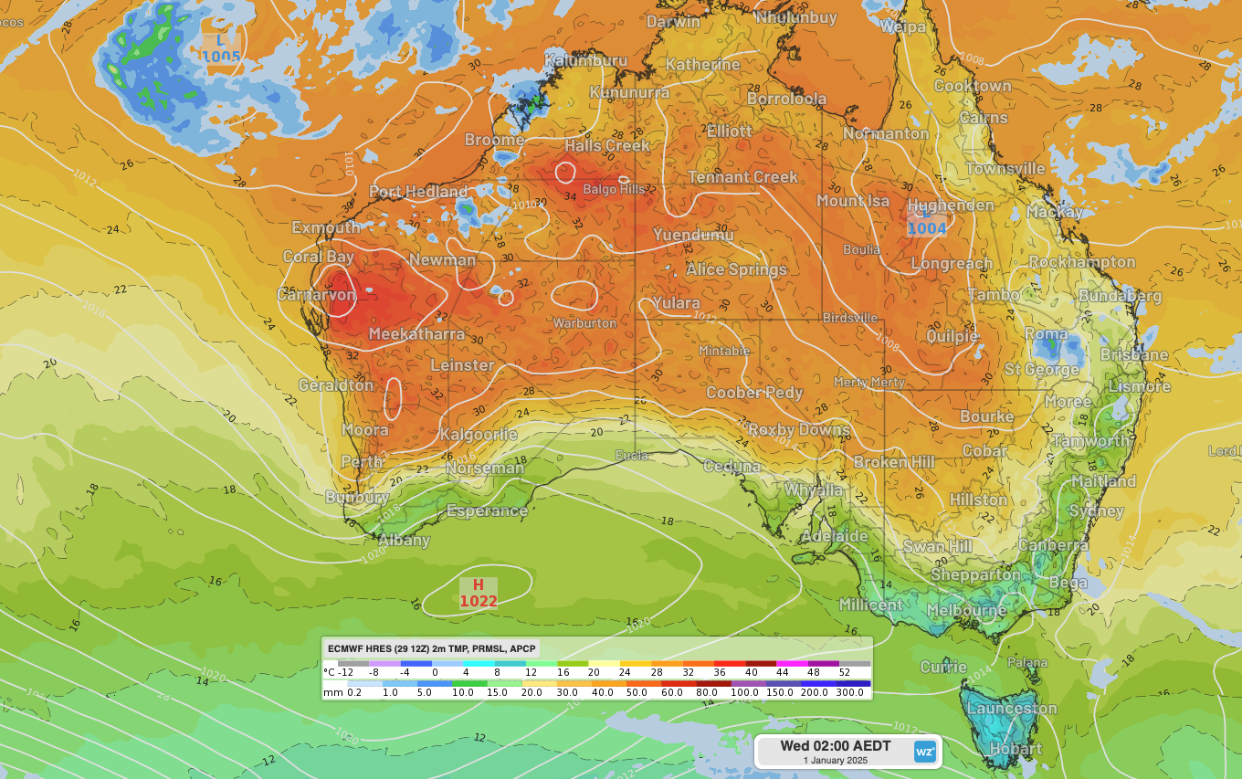
This year, the west and north wins first place for hottest, with Perth, Darwin and Cairns all heading into heatwaves while Tasmania and Victoria (no surprise) win coldest. Anti-clockwise from the west, the capital forecasts for New Year’s Eve and New Year’s Day are:
Perth and much of surrounding western and southern WA are in for a scorching pair of days straddling NYE, with temperatures in the high thirties or low forties expected around the region on both the 31st and 1st. Tuesday night will be hot in between, with the temperature likely to still be in the mid-twenties at midnight. A cooler change will start to filter over Perth on Wednesday evening (a gusty storm is possible) but won’t really displace the heat until late morning or early afternoon Thursday.
Adelaide is saving its heatwave for this weekend, after the hangover recovery. Dry, mostly clear and bang on average days around 29 or 30°C will grace the city on Tuesday and Wednesday, with a pleasant-for-sleeping minimum around 15°C in between.
Melbourne will be Melbourne. After flip-flopping between 34+°C and barely 20°C at least three times in the last two weeks, Melbourne is in a middling phase. Cool to mild southerly winds dominate and, while it should reach the mid-twenties on the 31st, a weak front brushing to the south will lead to a cooler start to 2025, complete with some Melbourne cloud at times and the chance of drizzle on New Year’s Day evening.
Hobart will be closer to the above-mentioned cold front than Melbourne and is likely to get a light shower or two on Wednesday, with a moderate chance also on Tuesday. Temperatures will hover around the typical December low twenties during the day, dropping to around the mid-teens for the year’s changeover, then down to around 10-11°C by dawn on Wednesday.
Canberra and surrounds are on board with Adelaide’s plan and will top out at 29 or 30°C on both Tuesday and Wednesday with a mid-teens night in between (likely in the high teens around midnight Tuesday). Tuesday will start mostly sunny, but an unusually early afternoon easterly will bring cloud and the moderate chance of a shower or two and a thunderstorm late afternoon and early evening.
Sydney is a similar story: warm days around 30°C on the coast and the mid-thirties inland will give way to cloud in the afternoons. There’s only a low chance of a shower or a storm for the city on Tuesday afternoon/evening but a higher chance for the western suburbs and Blue Mountains. These are most likely before midnight, but Sydney doesn’t always play nice. Wednesday will see a similar pattern though with a higher chance of storms throughout in the afternoon and evening as a trough deepens near the east coast and a southerly change marches northward. The humidity will help keep it above 20°C most of Tuesday night, particularly on the coast.
Brisbane will be muggy and warm and has the highest chance of showers of all the capitals at the important midnight Tuesday time. Showers, like in Sydney, will be more likely over the west and also to the north, around the Sunshine Coast and Capricornia to the southern Central Coast. These widespread showers and thunderstorms (some likely severe) are due to a lingering trough that will also be responsible for drawing in hot, humid northeasterly winds over the northeast Queensland coast, giving beachcombers in Cairns and surrounds a NYE that will struggle to drop below 25°C.
Darwin is, as often, doing its own thing. With the official monsoon yet to arrive, the northern capital continues to endure Build-Up type conditions with extremely high humidity combined with above average temperatures. Northerly winds are pumping humid and unstable air over the region, with the high chance of storms Tuesday evening but these are most likely before midnight. Temperatures could be kind enough to drop below 30°C for midnight Tuesday, but barely.
For up-to-date forecasts, check out the Weatherzone forecasts for your location at:https://www.weatherzone.com.au

Image: Temperature, 3-hr rain and mean sea level pressure forecasts at 2am AEDT Wednesday 1st January 2025, according to the ECMWF model.