
Negative Southern Annular Mode strengthening in Southern Hemisphere
Ongoing stratospheric warming above Antarctica looks set to influence weather patterns across the Southern Hemisphere into August as a strong negative Southern Annular Mode (SAM) takes shape.
The atmosphere above East Antarctica started to warm abruptly during the middle of July. This warming initially started in the polar stratosphere, around 30-40km above East Antarctica, but its influence has since filtered down towards the surface in the past fortnight.
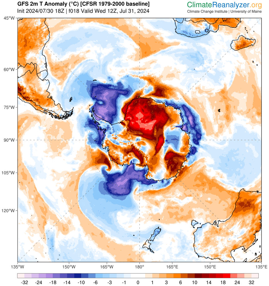
Image: Modelled surface air temperature anomaly over Antarctica on July 31, 2024. Source: ClimateReanalyzer.org
When the air above Antarctica gets warmer than usual during winter, it can weaken and destabilise the Southern Hemisphere’s polar vortex. This weakening of the polar vortex causes the westerly winds that flow around Antarctica to expand towards the equator, allowing polar air masses to spread further into the mid-latitudes. The expansion of the circumpolar westerlies and the associated cold air is defined as a negative phase of the SAM.
The Southern Annular Mode (SAM) is an index used to monitor the position of the westerly winds that flow from west to east around Antarctica. When the SAM is in a negative phase, these westerly winds, and the cold fronts and low pressure systems they carry, are located further north than usual for that time of year. When the SAM is positive, the westerly winds, cold fronts and low pressure systems are located further south than usual for that time of year.
The SAM has recently dipped into a negative phase in response to stratospheric warming above Antarctica. Forecast models suggest that further stratospheric warming will take place in the opening fortnight of August, causing the current negative SAM to get even stronger.
The graph below shows the SAM forecast from the NOAA Climate Prediction Center, based on the GFS model. This model suggests that the SAM index is currently sitting around -3 and could dip below -4 into the opening week of August. Other forecast models also show the current negative SAM phase lingering into August.
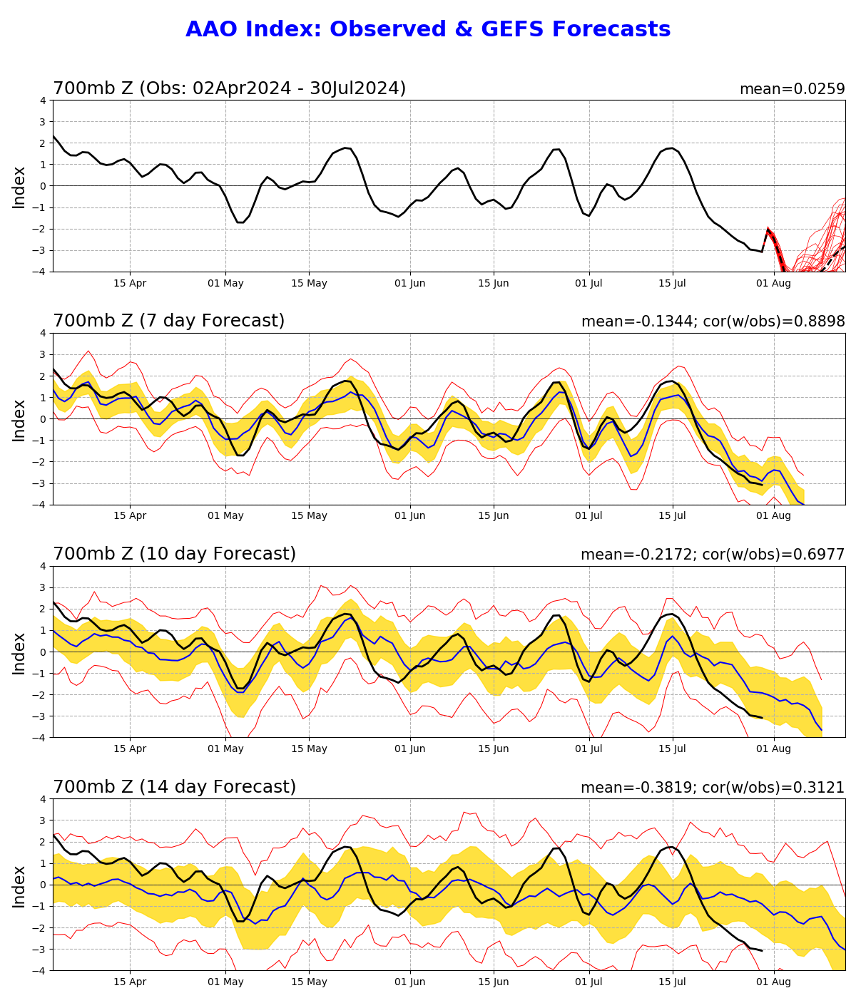
Image: SAM (also called the Antarctic Oscillation or AAO) index observations and forecast, showing a strong negative SAM phase underway that is expected to persist into August.
What does this mean for Australia?
As mentioned earlier, a negative SAM causes the westerly winds, cold fronts and low pressure systems that circulate Antarctica to move further north than usual. In winter, a negative SAM typically causes the following impacts in Australia:
- More frequent cold fronts and low pressure systems over southern Australia
- Increased rainfall and snow potential in southwest and southeast Australia
- Reduced rainfall in parts of eastern Australia
- Stronger winds in the southern half of Australia
However, no two negative SAM events are the same and there are other factors that will determine how this negative SAM impacts Australia’s weather in the coming weeks.
One key factor will be the shape of the circumpolar westerly wind belt as it expands away from Antarctica. Forecast models suggest that the westerlies will meander as they flow through the Southern Hemisphere’s mid-latitudes, which is called a meridional pattern.
This meandering flow will cause a long-wave pattern with large nodes of cold air and low pressure next to regions of warmer air and higher pressure in the mid-latitudes. This alternating pattern of low and high pressure should cause countries in the Southern Hemisphere’s mid-latitudes to fluctuate between periods of relatively warm and stable weather and periods of colder and more unsettled weather during the coming weeks.
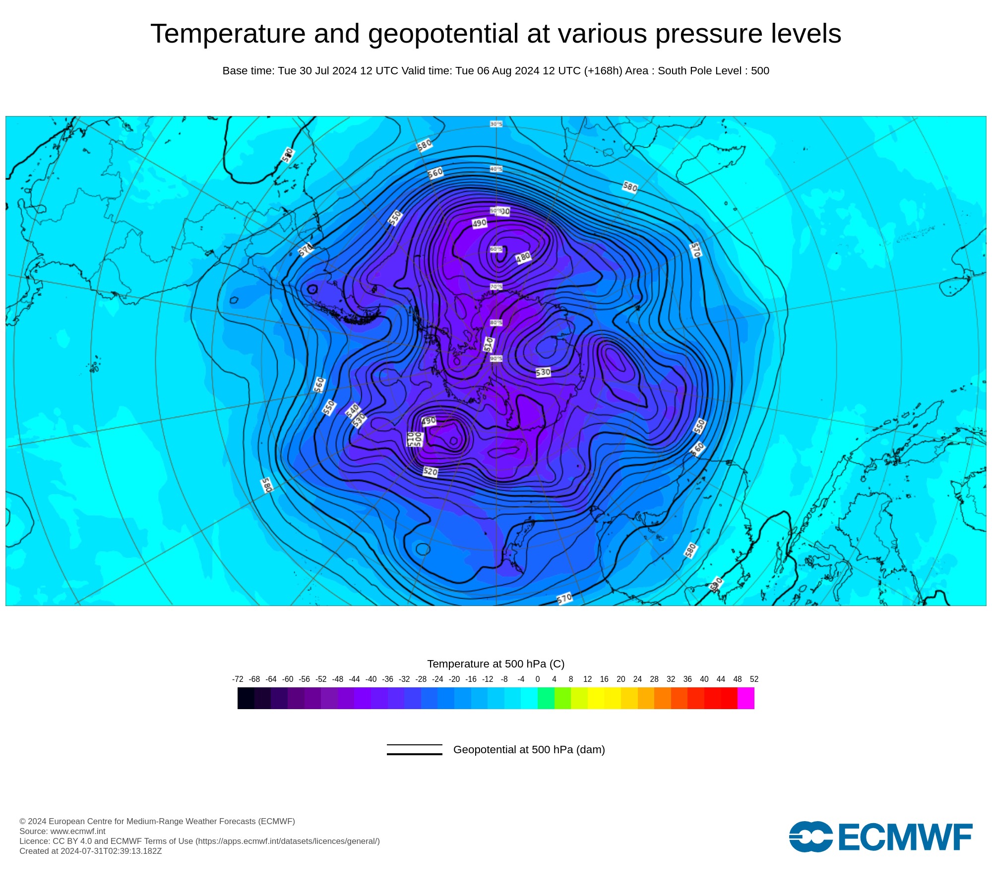
Image: Modelled temperature and geopotential height at 500 hPa (about 5km above sea level) on August 6, 2024, showing nodes of cold air and low pressure surrounding Antarctica. Source: ECMWF
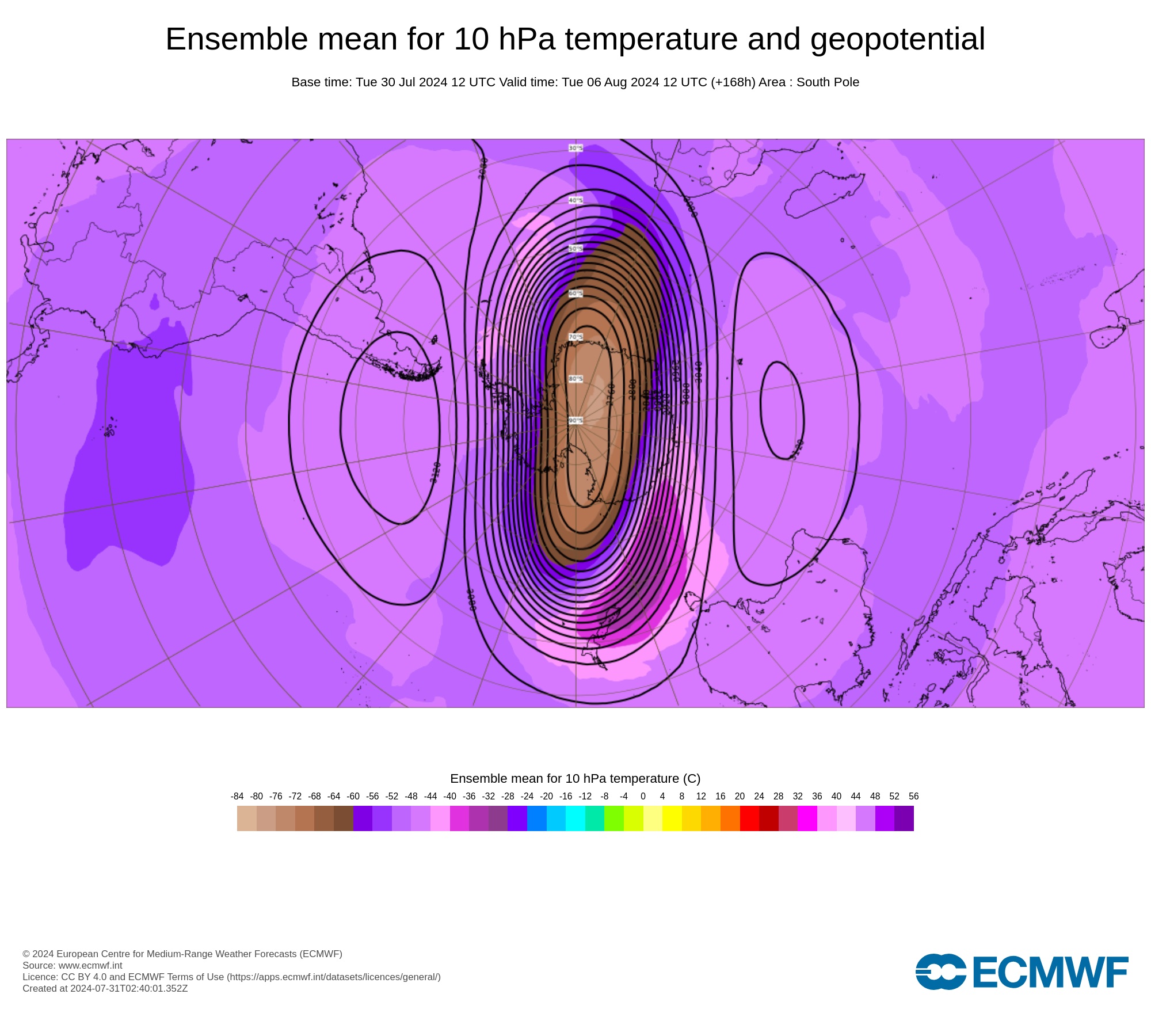
Image: Modelled temperature and geopotential height at 10 hPa (about 30km above sea level) on August 6, 2024, showing an elongated polar vortex in the stratosphere above Antarctica. Source: ECMWF
The current strong negative SAM phase will make rain, wind and cold weather more likely in southern Australia during late winter and early spring. However, this wintry weather will likely be interspersed with periods of drier and more stable weather.
If we do continue to see this alternating pattern of amplified high and low pressure beyond August, it will increase the likelihood of large thunderstorm outbreaks in Australia during spring.
It’s too early to know if, and how, this stratospheric warming event will continue to influence weather patterns in the Southern Hemisphere into late spring and summer. However, past stratospheric warming events have had a strong influence on late spring and summer weather in Australia, so this will be something to keep a close eye on in the coming months.