More record-breaking heat in Perth
Perth is eyeing off another summer heat record this week with temperatures set to reach the high-thirties in the city for at least the next six days.
Western Australia’s Lower West Coast has been no stranger to extreme heat this season.
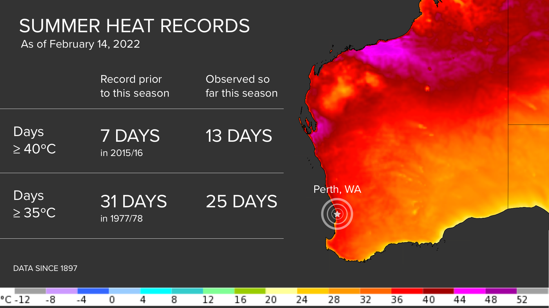
Perth has already registered 13 days at or above 40ºC so far this summer, which wallops the previous summer record of seven days from 2015/16.
Now, the city is on track to also break the record for the number of days at or above 35ºC in a single summer.
As of 9am on Tuesday, February 15, Perth had registered 25 days at or above 35ºC so far this season. The current record for summer in Perth is 31 days from 1977/78.

Based on current forecasts, Perth could reach or exceed 35ºC on each of the next six to nine days. This should allow the city to match the summer record of 31 days at or above 35ºC by Sunday and possibly break the record early next week.
This summer’s unrivalled number of 40ºC and 35ºC days is exceptional becuase Perth has more than 120 years of historical observational records, with data available back to 1897.
What has made this season so hot in Perth?
While Australia’s warming climate is likely to have played a role in this season’s extreme heat in Perth, there were several local weather factors that helped cause the record-breaking heat.
La Niña played a role in this summer’s hot weather in Perth. While La Niña has caused relatively cool and wet weather over many parts of Australia this season, the county's west coast has sweltered with an abundance of sunshine and record-breaking heat.
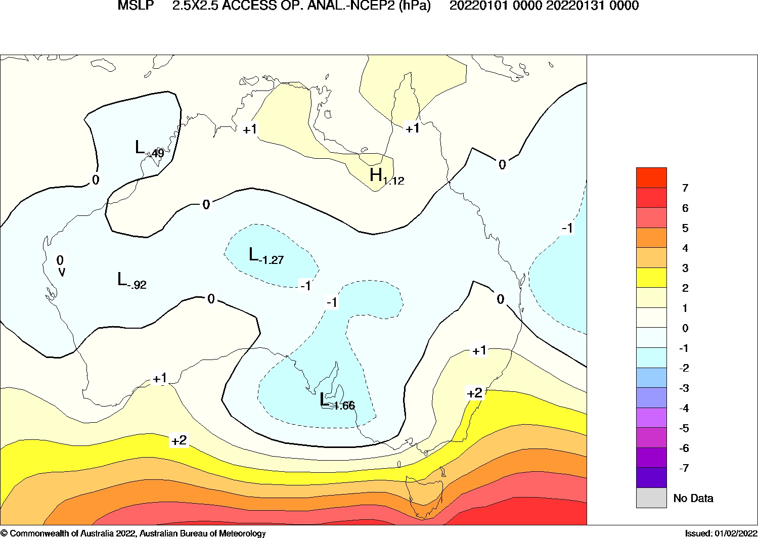
La Niña promotes extreme heat in WA because it is directly correlated with more periods of positive Southern Annular Mode (SAM). When the SAM is positive in summer, high pressure systems frequently sit further south and become more prominent over or to the south of Southern Australia. This abnormal pressure pattern pushes cold fronts further south than normal for this time of year.

Image: Mean Sea Level Pressure (MSLP) anomalies during January 2022 showing high pressure anomalies over southern Australia. Source: Bureau of Meteorology.
When high pressure systems sit further south in summer, it directs prevailing easterly and northeasterly winds over southern parts of the continent.
For eastern Australia, these easterly winds are usually moisture-laden and cool, causing days of cloud and rain. While for the nation's west coast, prevailing easterly winds are generally dry and hot, originating from the interior of Australia.
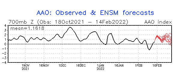
The graph below shows that the SAM index has been predominantly positive so far this summer.

Image: Observed Southern Annular Mode (SAM) index values during the last few months. Source: NOAA/CPC
The SAM is expected to stay positive for the rest of February, as shown by the red lines on the graph above. This should help promote more warm weather in Perth in the final two weeks of the season.
Another factor that has led to unusually high temperatures in Western Australia this summer was a slow start to the wet season in northwestern Australia.
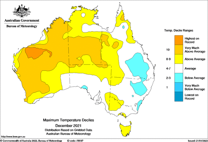
A lack of monsoonal cloud in December and January caused extremely hot airmasses to build up in the Pilbara and Kimberley. This hot air spread to other parts of Western Australia at times, including the state's southwest.

Image: Observed maximum temperature deciles during December 2021, showing record-breaking daytime heat in northwestern Australia. Source: Bureau of Meteorology.
The peak of this season's heat saw Onslow Airport reach 50.7C on January 13, which was the equal highest temperature on record in the Southern Hemisphere. While Perth hasn't been quite this hot, it has certainly been a record-breaking season for the state's capital city.