More heavy rain for Qld, northern NSW
Unseasonably heavy rain continued overnight for large parts of Queensland and NE New South Wales, with 24-hour totals over 100 mm recorded in at least two locations in both states.
The unusual winter deluge is being caused by a deep layer of moisture fed by east-northeasterly winds interacting with a pair of upper-level low pressure systems, with rain falling for the majority of a 48-hour period in many spots.
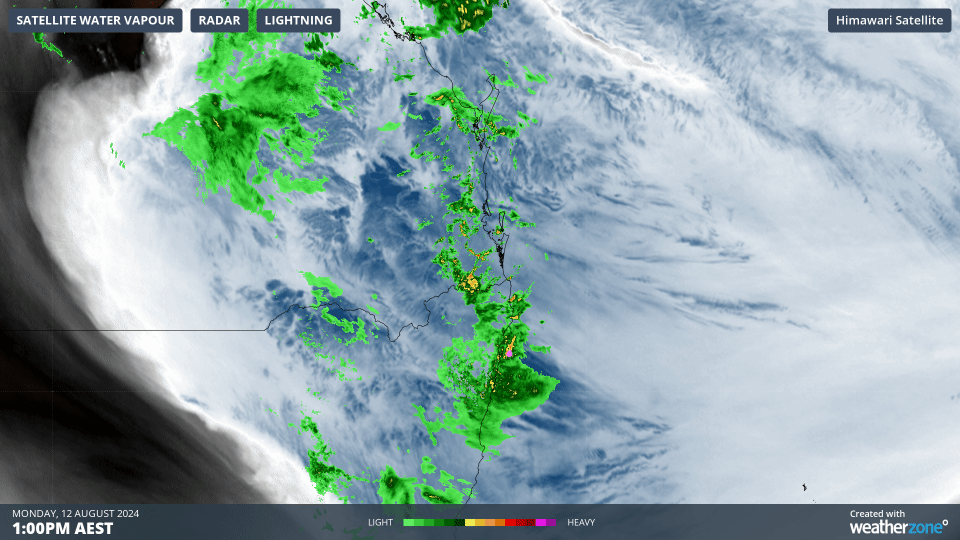
You can see the moisture feed (the underlying blue and white) and the heavy rain (green and yellow radar blobs) on Monday afternoon in the loop above, when precipitation was at its heaviest in many areas.
Observations of note in NSW included:
- Ballina on the NSW North Coast saw 95.4 mm to 9 am Tuesday. That came after 116.2 mm in the 24 hours to 9 am Tuesday. That’s a 48-hour total of 211.6 mm, which is well over the August average of 85.7 mm. Indeed August is one of just two months of the year in this wet corner of Australia where the average monthly rainfall is less than 100 mm.
- The heaviest 24-hour NSW rainfall to 9 am Tuesday was 104 mm at Tuckombil, a weather station near Lismore. A minor flood warning is in place for Lismore’s Wilsons River, the river that caused such devastation when it flooded in February, 2022.
- The Loaders Lane weather station in Coffs Harbour, a little further down the coast, saw exactly 100 mm.
Observations of note in Qld included:
- Widespread heavy falls in the Central Highlands and Coalfields Forecast District, including several falls exceeding 50 mm at locations as far as 300 kilometres from the coast.
- 71.6 mm at Rockhampton, the city’s heaviest August fall in 36 years.
- 101 mm at Mt Goonaneman, a 670-metre peak just southeast of Bundaberg.
- 110 mm at Hills Road, a weather station about halfway between Gladstone and Bundaberg
- Willis Island received 112.6 mm to 9 am Tuesday, which was its heaviest day of rainfall in any month in eight years. That's the red dot you can see way out in the Coral Sea in the map below.
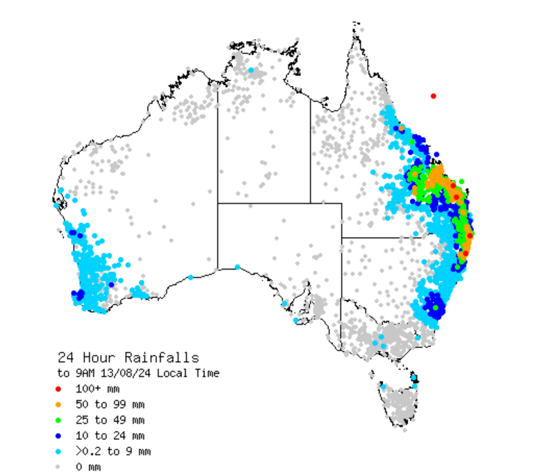
Source: BoM.
This event is not done yet. More heavy rain is expected in some of the areas mentioned, with coastal locations likely to see the heaviest falls.
Brisbane is in for its fair share, having thus far received a modest 15.6 mm over two days from this event. From Tuesday morning onwards, a 48-hour total in the range of 40 to 80 mm is possible for the Qld capital.