Mesoscale low drenches NSW Hunter, Central Coast regions
Newcastle and parts of the NSW Central Coast and Hunter forecast districts received very heavy rain and gale force winds over the weekend, as a mesoscale low formed over the area.
A mesoscale low is a relatively small, localised low pressure system area that is larger than individual thunderstorms, but smaller than the broad-scale weather pattern with which it is associated.
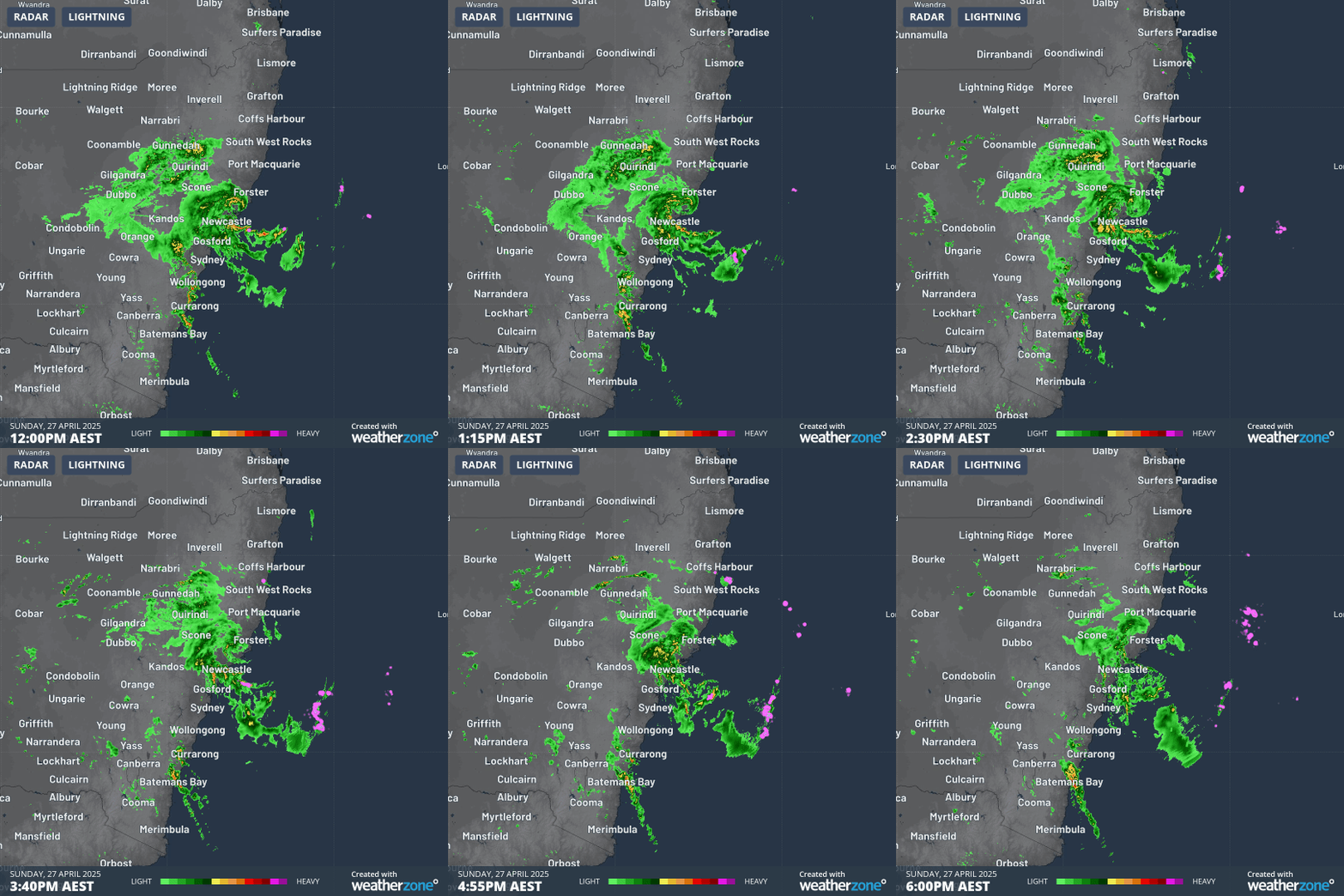
You can see the swirling vortex of rain and storms briefly forming an eye reminiscent of a tropical cyclone just north of Newcastle on Sunday afternoon in the radar loop below (while Sunday's system may appear similar to a tropical cyclone, the underlying dynamics are fundamentally different).

Image: Six-hour radar loop from midday to 6pm for coastal NSW on Sunday, April 27, 2025.
It was during that period in the early afternoon that the highest wind gust of 93 km/h was recorded at the beachside weather station of Newcastle Nobbys.
Meanwhile, some of the notable 24-hour rainfall observations to 9am Monday included:
- 154mm Mandalong (a rural area just west of Lake Macquarie)
- 139mm in the southern Newcastle suburb of Windale
- 135mm at Lake Macquarie-Cooranbong
- 134mm at Mount Barrington, a 1555m summit on the Barrington Tops, about two hours northwest of Newcastle
Sydney also had a wet weekend, with falls of 25mm and 38mm in the 24 hours to 9am Sunday and Monday respectively.
That brought the city’s April rainfall to 140.3mm - the third of four months to date in 2025 with above-average rainfall, after five of the last six months of 2024 saw below-average totals.
But the main impacts of the weekend’s wild weather were felt just north of Sydney, an hour or two up the M1 freeway and slightly further afield. The NSW SES performed 16 flood rescues over the weekend, and a Flood Watch is in place for parts of the Mid North Coast, Central Coast and Hunter catchments.
The wild weekend weather came just days after a magnitude 4.6 earthquake struck the Hunter region, with no damage reported but shaking felt as far north as Port Macquarie and as far south as Wollongong.
As for the week ahead, further rain is expected along already sodden stretches of the NSW coastline, with another 100 mm set to fall in some locations.
Both Sydney and Newcastle can expect persistent showers all the way through till at least Sunday, with showers increasing midweek as a coastal trough deepens.
Other parts of the NSW coast also face an extended period of umbrella weather, with the far South Coast likely to see the lightest falls.