
Landfall won't be the end of Alfred's impacts – what to expect in the coming days
Tropical Cyclone Alfred’s severe weather will affect parts of Queensland and NSW for several days, with heavy rain and flooding to persist long after the system makes landfall.
Heavy rain, squally winds and pounding surf battered southeast Qld and northeast NSW on Thursday night into Friday morning as Tropical Cyclone Alfred lingered around 200 km to the east of Brisbane.
The animation below shows a large area of rain on the southern and western flanks of Alfred impacting parts of eastern Australia on Thursday night into Friday morning.

Image: Satellite and radar imagery showing Tropical Cyclone Alfred driving heavy into Australia's east coast on Thursday night and Friday morning.
As of 6:30am AEDT on Friday, some areas northeast NSW and southeast Qld had received 100 to 160 mm of rain since 9am on Thursday. A few rain gauges in northeast NSW registered about 60 to 70 mm of rain in the 6 hours ending at 6am AEDT.
This heavy rain was accompanied by wind gusts of 100km/h or higher in some coastal areas of southeast Qld and northeast NSW. The highest wind gust as of 9am AEDT on Friday was 120 km/h at Cape Byron, which is the easternmost point of the Australian mainland.
What is Alfred going to do next?
Severe weather will continue to batter parts of southeast Qld and northeast NSW on Friday as Tropical Cyclone Alfred slowly approaches the coast and eventually makes landfall.
At this stage, landfall should occur on Saturday morning somewhere between Noosa and Coolangatta, most likely north of Brisbane. However, Alfred has been moving erratically over the past couple of days and its future track could feature more wobbles, with computer models suggesting that Alfred’s coastal crossing could be a prolonged process.
One positive aspect of the current forecast is that Alfred is expected to weaken as it approaches southeast Qld. This is due to the system’s slow movement causing it to churn up cooler waters at the ocean’s surface and increasing friction with land as it gets closer to the coast.
Unfortunately, that’s about all the good news there is for residents in southeast Qld and northeast NSW. Alfred is still expected to make landfall as a tropical cyclone and will deliver a prolonged period of severe weather over the next few days.
The main threats between now (Friday morning) and the time of landfall (most likely Friday night or Saturday morning) will be heavy rain, damaging to destructive winds, massive waves and abnormally high tides. These impacts will be most intense near and to the south of the cyclone’s centre as it approaches the coast and makes landfall.
Like all tropical cyclones, Alfred will weaken rapidly after it crosses the coast and should have dropped below tropical cyclone strength by Saturday night. However, that won’t be the end of its dangerous weather.
Heavy rain is expected to persist over parts of southeast Qld and northeast NSW on Saturday and Sunday in Alfred’s wake, with lingering moisture also expected to produce further rain and thunderstorms early next week. Damaging winds and dangerous surf should also linger into Saturday.
The inland movement of Alfred’s remnants will then carry areas of heavy rain over southern inland Qld and northern inland NSW on Sunday and possibly towards central NSW, including Sydney, by Monday.
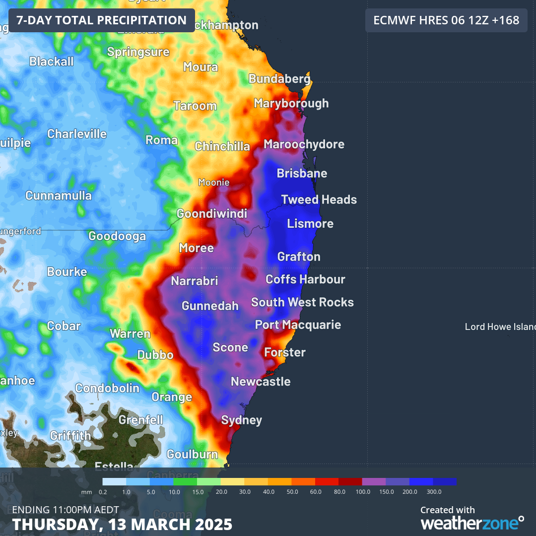
Image: Forecast accumulated rain during the next seven days, although most of this will fall between this Friday and Monday next week.
Every additional hour of rainfall that occurs in the coming days will be adding more water into already saturated catchments and flooded rivers. This prolonged rainfall is likely to cause flash flooding and major riverine flooding in northeast NSW and southeast Qld from Friday into the weekend.
Anyone in southeast Qld or northern and central NSW should keep up to date with the latest tropical cyclone advisories and severe weather and flood warnings in the coming days.