Kirrily leaves tens of thousands without power
Severe Tropical Cylone Kirrily made landfall on Thursday night just north of Townsville and has now weakened to a tropical low.
Strong winds lashed the city of Townsville and nearby areas, leaving an estimated 50,000 people without power.
At this stage, it appears the strongest gust associated with system was 143km/h at Flinders Reef on Thursday, while the popular tourist detination of Hamilton Island copped gusts up to 115km/h.

Image: The cyclone track map over the past week from tropical low to cyclone, and back to tropical low. Source: BoM.
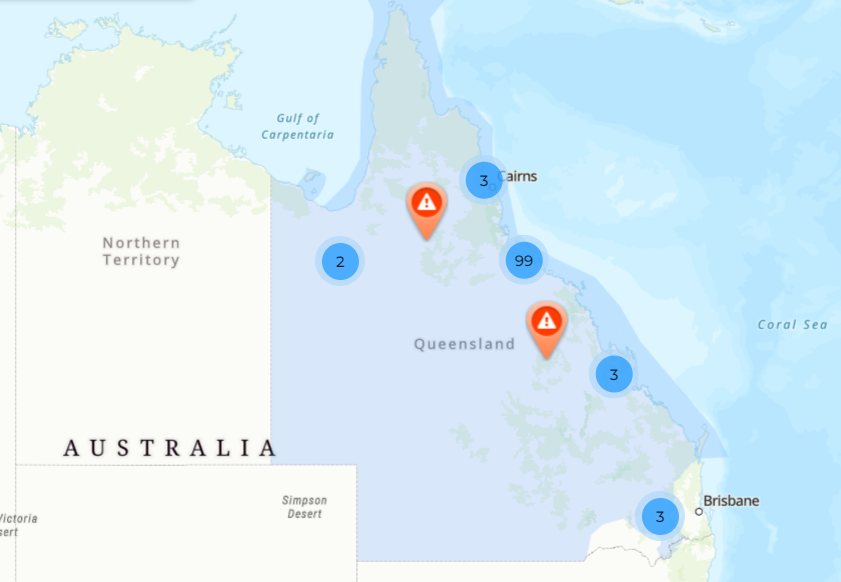
The image above shows the progression of this system over the past week, while below, you can see a map of power outages in Queensland, courtesy of Ergon Energy.

Image: This interactive map allows you to learn the cause of each outage by clicking on the relevant area. Source: Ergon Outage Finder.
There are no reports of major structural damage in Townsville, however trees are down across the city and there is widespread damage to sheds and fences, while some yachts broke their moorings.
More yachts coming to grief down on the Strand as the back side of #CycloneKirrily continues to pack a punch here in #Townsville ????
— Jason H (AU) ???????? (@OreboundImages) January 25, 2024
? Not for media use ? pic.twitter.com/UPbZWQ3Vsx
While Kirrily reached Category 3 status on Thursday night – which the BoM classifies as likely to produce "very destructive winds with some roof and structural damage, some caravans destroyed, significant damage to crops and trees, and power failures likely" – the flood threat always appeared to be one of the most dangerous aspects of this system.
The flood situation will unfold in coming days, as the ex-cyclone tracks in a southwesterly direction as a tropical low, delivering heavy rain to communities and catchments in its path.
As ever, please check our warnings page for the latest flood information.