
'Intense rainfall' warning for NSW, with 300 mm possible in six hours
The Bureau of Meteorology has issued a series of warnings for severe weather and flooded rivers in northern NSW, as a coastal trough deepens over northeastern NSW.
Earlier today, Weatherzone meteorologist Ben Domensino described this system as "an eerily similar weather pattern to the one that caused catastrophic flooding at the end of February and early March".
Worryingly, it now appears that some of the impacts of this system could be similar too.
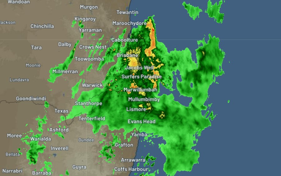
Image: SE Qld and NE NSW radar just after 6 pm Monday evening.
The full list of NSW warnings is here. It includes:
- An initial moderate to major flood warning from early Tuesday for the Wilsons River, which runs through Lismore. The river level is expected to reach close to the levee height of 10.6 metres on Tuesday afternoon.
- An initial major flood warning for the Bellinger and Kalang rivers, a little further down the coast in the Coffs Harbour area.
- A severe weather warning for heavy rain and thunderstorms with locally intense falls over northeastern NSW on Monday evening.
The severe weather warning above was issued just before 5 pm on Monday evening and makes for some sobering reading.
- It warns of possible six-hourly rainfall totals between 80 and 140 mm, reaching up to 200 mm over coastal areas and ranges.
- It also warns of life-threatening flash flooding possible with thunderstorms, and that storms could generate even higher six-hourly rainfall totals in excess of 200mm, possibly reaching up to 300mm.
- Damaging wind gusts are also a chance around the coast on Tuesday, with peak gusts of 90km/h possible.
It goes without saying that all of this rain is falling on already saturated ground, so please take every precaution if you live on the NSW north coast, and be aware that the NSW SES has already issued evacuation warnings for low-lying parts of Lismore.
We have issued â—ï¸EVACUATION WARNINGSâ—ï¸ for low lying parts of North Lismore and parts of South Lismore, to stay up to date with our current warnings visit👉https://t.co/t578A4vhe8
— NSW SES (@NSWSES) March 28, 2022
We'll update this extremely dangerous situation first thing in the morning. Stay safe, everybody.