
Intense rain and storms flooding Australia's interior
Parts of Central Australia are awash in the heaviest rain and storms in years, leading to flooding which has the potential to become widespread.
For much of this region, January-to-March is typically the wettest time of year. the only months Birdsville has had daily rainfall exceed 100 millimetres in its 132-year history. However, but this time around it is enhanced by a developing monsoon flow across the tropics sending tropical moisture to the interior.
Flooding has already occurred in parts of South Australia's far north, the Northern Territory's south and eastern interior and Queensland's far west, already a boost for wildlife and plants but also enough to impact transport.
Some of the most significant rainfall has so far been
So far, it's been the heaviest rainfall in -
5 years at Birdsville in Qld (more than 70mm in about 24 hours, twice the monthly average)
3 years at Ernabella (Pukatja) in SA (61mm in 24 hours, twice the monthly average)
2 years at both Coober Pedy in SA (30mm in 24 hours, three times the monthly average) and Urandangi in Qld (90mm in 24 hours, one-and-a-half times the monthly average)
10 months at Indiana in the NT (22mm in 24 hours)
and 4 months at both Boulia (27mm in 24 hours, about half the monthly average) and Charleville (42mm in 24 hours, abut half the monthly average) in Qld
The rain has since stopped in the Coober Pedy, Pukatja, Uluru and Alice Springs area, but the dampness left behind has contributed to a misty Sunday morning, even quite foggy in patches.
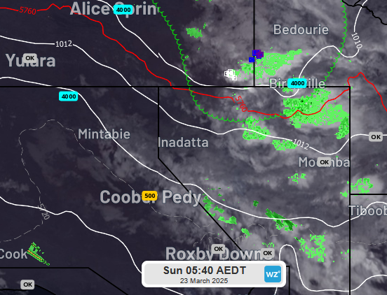
Image: visibility in metres indicated on radar and satellite image just before sunrise this morning.
From here into the coming week, the focus will shift from Central Australia to Qld's interior as a moisture-filled trough slowly edges east, bringing a flood risk to multiple districts. There is the potential for a few hundred millimetres of rain across a large area, likely cutting off roads (particularly unsealed roads, leaving some communities isolated.
One such community could be Alpurrurulam near the NT/Qld border, an 11-hour drive from Alice Springs, a fair chunk of it along unsealed roads. The area is forecast rain and storms each day for the next week, likely amounting to more than 100mm.
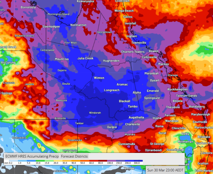
Image: Forecast rainfall from one model (ECMWF) for the 8 days to 10pm EST Sunday 30 March.
The Channel Country will be one of the regions where flow-on effects will surely be long-lasting, with Diamantina and Georgina rivers and Cooper Creek delivering water to Kati Thanda-Lake Eyre for the next few months.
Locals and travellers are urged to prepare by checking road conditions and warnings. Drivers should also take extra care, given the initial rain is drawing kangaroos and other wildlife to flooded roadsides
Locals and travellers are urged to prepare by checking road conditions and warnings. Drivers should also take extra care, given the initial rain draws kangaroos and emus to flooded roadsides.