
Inside the eye of Hurricane Ida
Satellites and 'Hurricane Hunters' have given us a glimpse inside the eerie eye of Hurricane Ida, which slammed into the coast of Louisiana on Sunday.
After battering western Cuba last Friday, Hurricane Ida rapidly intensified as it traversed warm Gulf of Mexico waters over the weekend.
By the time Ida reached the Louisiana coast on Sunday, it was a powerful category four hurricane packing sustained one-minute wind speeds of 241 km/h and instantaneous wind gusts of 386 km/h.
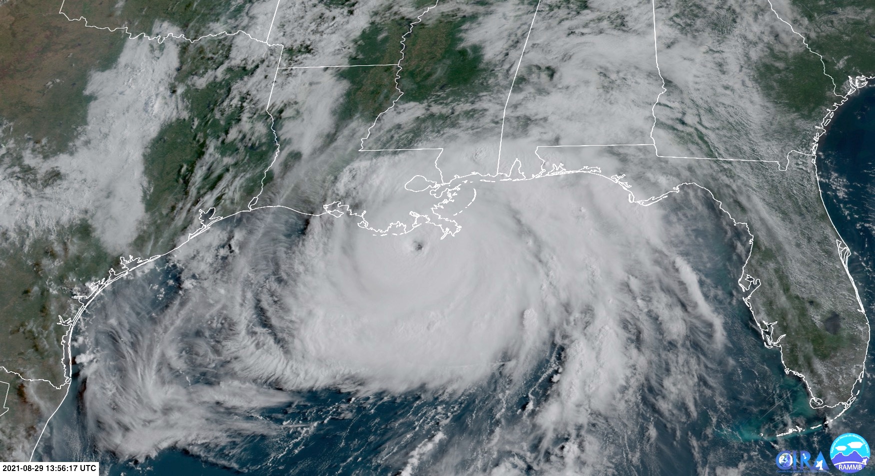
Image: Hurricane Ida shortly before landfall on Sunday. Source: RAMMB/CIRA
The landfall of this immense hurricane has caused a destructive mix of powerful winds, sustained heavy rain, thunderstorms and coastal inundation from a large storm surge.
Hurricanes this strong, in this part of the United States, are known to cause widespread power outages and long-lasting flooding that can cut communities off for weeks on end.
But while the full story of Hurricane Ida's impacts is yet to be told, the last 24 hours of its life have been documented in exceptional detail.
Hurricanes that strike U.S. soil are subjected to an incredible amount of analysis. It's some of the most comprehensive real-time weather monitoring of any individual weather system on our planet.
Satellites have been capturing high-resolution images of Hurricane Ida at one-minute intervals during its approach to Louisiana. These images are so detailed that they allow us to see inside the hurricane's eye.
Mesovortices within Hurricane Ida's eye.
— Dakota Smith (@weatherdak) August 29, 2021
Just a spectacular view. pic.twitter.com/Re3ZPnjlpX
The video above, which was posted on Twitter by Dakota Smith from the Cooperative Institute for Research in the Atmosphere (CIRA) at Colorado State University, shows small swirls of cloud inside the Hurricane Ida's eye.
These swirls are called mesovortices, which are intense small-scale circulations that develop in the eyewall of powerful hurricanes. Wind speeds in these mesovortices can be around 10% higher than the rest of the eyewall and they can also help tornadoes develop after landfall.
I count 4 mesovortices rotating around the outer portion of #Ida's eye, evident in the low cloud field. And the eye is now *completely over land*! I don't think I've seen this before with a storm over land. #GOES16 pic.twitter.com/34i1ovISZp
— Dan Lindsey (@DanLindsey77) August 29, 2021
But if images of Hurricane Ida's eye from space weren't impressive enough, how about these ones from inside the eye itself?
The National Oceanic and Atmospheric Administration (NOAA) Hurricane Hunters have been sending aircraft on reconnaissance missions inside the system's eye to take atmospheric observations.
The crew got the blades turning a little early to be able to make two passes through the eye as Hurricane #Ida made landfall. Here’s what we saw: pic.twitter.com/BrwKwFVQiB
— Hurricane Hunters (@53rdWRS) August 29, 2021
The photos and videos from these planes give us a glimpse of what it's like to be inside a hurricane's eye while its spinning over open water.
The data collected by the Hurricane Hunters helps meteorologists determine how strong a hurricane is and how it will impact communities once it makes landfall.
Another unique view from inside the eye comes from the cameras being held by storm chasers and residents that find themselves directly in the path of one of these destructive systems.
Birds resting in the median of US-90 near Matthews, LA, inside the eye of Hurrican Ida. These birds might be Cuban. #ida #HurricaneIda @MyRadarWX pic.twitter.com/Mm2j80uGYY
— Aaron Jayjack (@aaronjayjack) August 30, 2021
It can become eerily calm inside the eye of a hurricane, although the destructive eye-wall winds are usually not too far away.