Huge temperature contrasts in SE Aus today
If you draw a line from Brisbane to Adelaide and call everything to the right of that line "southeastern Australia", then SE Aus is a region of strong temperature contrasts this Friday.
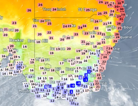
From sub-zero temps in the mountains to low 30s in northern NSW and SE Qld, there's pretty much every temperature for every taste.
- As we write this story around midday (AEDT) on Friday, it's -1°C at Thredbo while it was 30.6°C at Evans Head on the NSW North Coast. That's a real-time temp differential of 31.6 degrees in the same state, and for the record, there's even a little light snow falling at the top of Thredbo.
- There are also strong temp differences between Sydney and Melbourne today, with Sydney sitting on 23.1°C and Melbourne 15.2°C at midday.
- Meanwhile, Brisbane is heading for its third consecutive day (in what should be a run of about six days) of max temps on or above 30°C. Indeed, yesterday's top of 34.3°C wasn’t far off the Qld capital's hottest max to date for 2022, which was 35.5°C on Feb 2.

Why such big contrasts today?
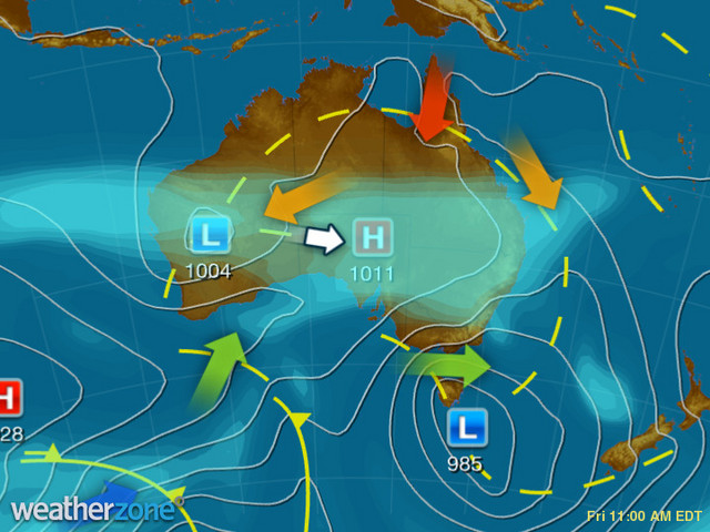
From time to time in spring, a Southern Ocean low pressure system pushes cool winds towards the Australian mainland, but they generally don't extend too far beyond Victoria and perhaps southern NSW.
So in simple terms, this system has only travelled so far north.

There are also some more complex factors at play. For example, the east coast tends to be insulated from the coolest temperatures, due to air warming as it descends after crossing the mountains.
One interesting aspect of today's weather is that it's just a warm-up for the big cool-down next week, when a much stronger series of cold fronts will usher in a strong unseasonable chill, with heavy spring snow likely for the mountains and a cold, wet, blustery week for the Melbourne Cup carnival.