
Huge snow loss after overnight 'hair dryer'
In the mountains, they call it the "hair dryer". It's the combination of very strong winds and warm air, and it decimates the snowpack in the Australian alpine region. Throw in rain, and the effect is like an esky full of ice that has been left in the sun on a blazing hot summer day.
Throughout Tuesday and overnight into Wednesday morning, hair dryer conditions lashed the mountains, combined with moderate falls of rain in the 10 to 15 mm range.
- At Australia's highest and weather station at the top of Thredbo, the average August minimum is –4.8°C. Overnight it stayed well above zero with a strongest wind gust of 107 km/h at 5:15 am.
- At Victoria's highest weather station near the summit of Mt Hotham, where the average August minimum is –3.5°C, it also stayed well above freezing with a strongest gust of 109 km/h just before 1 am.
- Have you ever heard of Cabramurra, Australia's highest town at an elevation of 1482 metres? The tiny settlement in Kosciuszko National Park was established in the 1950s to house workers on the original Snowy Mountains hydro-electric scheme. Overnight its min was a very balmy 4.4°C with a strongest gust of 74 km/h.
We mention Cabramurra because it's the nearest official weather station to Australia's northernmost ski area Selwyn Snow Resort, where the grim Wednesday morning scene is pictured below.
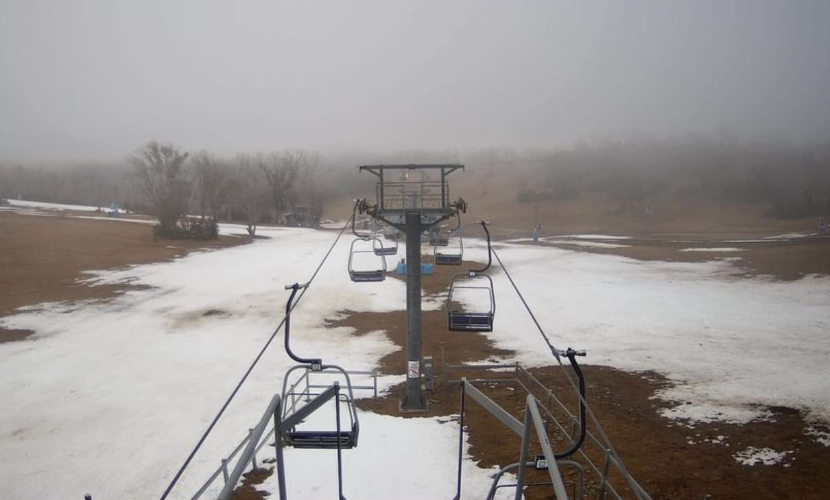
Image: Selwyn still has two lifts open as well as the toboggan area for visitors, but for how much longer? Source: ski.com.au.
The graph below compares snow depths in 2023 and 2024 at Spencers Creek, at an elevation of 1830m roughly halfway between the NSW resorts of Perisher and Thredbo.
Spencers Creek is almost 300 metres higher than the top of the chairlift pictured above at Selwyn, which is why its depth measured yesterday (August 20) was still 101.cm (the dark blue line).
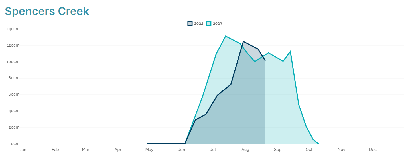
Source: Snowy Hydro.
But while there is still a reasonable snowpack at Australia's highest elevations, the news for snow lovers is not great for two reasons.
- Firstly, there has been significant snow loss in the overnight hair dryer since yesterday's measurement, so the depth at Spencers would already be lower.
- Secondly, a metre of snow might sound like a decent snowpack, but it’s actually well below the average for late August. Indeed the 2023 and 2024 graphs (above) are looking remarkably similar right now, with an earlyish peak, followed by a decline in depth with very little in the way of top-ups.
In slightly better news, a flake or two is on the forecast over the next day or two as slightly cooler air moves in. But the cold front crossing Bass Strait is what snow enthusiasts call a "clipper", meaning it's just clipping the mainland.
Regular visitors to the Weatherzone snow page will have noted that more significant snowfalls are in the forecast from about the middle of next week. Models are currently uncertain about the strength of that system, but it is definitely make or break time for the Australian snow season.
There is still a slim chance that 2024 could "do a 1992" – a year when peak depth of more than three metres occurred in mid-September after a sluggish start to winter.
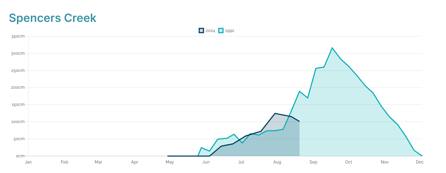
Image: 2024 (dark blue) vs the famously big late season of 1992 (light blue). Source: Snowy Hydro.
But for the 2024 season to come anywhere near 1992, next week's system needs to deliver, and big time.