
How cold will Queensland get this week?
The Sunshine State will be true to its nickname this week, but the sun won't help the southern half of Queensland warm up too much, as it continues to experience the chill which is already creeping its way northwards over the NSW border on Tuesday.
- Brisbane is looking at two straight days with maximums below 20°C for the first time this year, with tops of 19°C predicted for Wednesday and Thursday.
- Brisbane actually had a colder day earlier this month, with a top of just 18.2°C on May 21, the coldest day of 2022 to date. But there were cool southeasterly winds and persistent rain that day, both of which helped keep temps down.
- This time, the weather set-up is different. Brisbane will experience its cool midweek temps while staying dry.
So what's causing the cold temps in southern Qld?
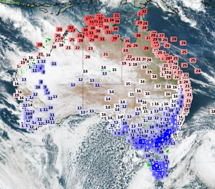
That blast of polar air (which you can see represented by speckled air in the Great Australian Bight in the image below, taken around 1 pm on Tuesday) has surged its way all the way up to Central Australia and southern Qld.
While the cold is accompanied by moisture in Victoria, Tasmania and parts of SA and NSW, Queensland is copping the chill without the chance of much more than a light shower over the Granite Belt.
Where will be coldest?
Stanthorpe, of course. At an elevation of 870 m, the town of 5,400 residents on the Southern Downs, just half an hour north of the NSW border, is renowned for being the only Qld town that sees very occasional snowfalls.
There's virtually no chance of flakes this week, but with a top of just 11°C on Wednesday, it’ll feel like the snowfields down south when you factor in the wind chill.
Meanwhile as we write this story, the smaller nearby town of Applethorpe (at a similar elevation to Stanthorpe) was just 9.8°C at 1:20 pm, with a "feels like" temp of just 2.3°C due to wind chill.
What about nights?
Things will get interesting by Wednesday and Thursday morning in inland parts of southern Queensland.
No negative minimums are on the forecast at present, but that could change, and there will certainly be enough low single-digit temps to enable the chance of light frosts.
Overall, it's highly unlikely that any temperature records will be broken with the current Qld cool spell. Indeed, winter starts on Wednesday, so it's the sort of weather that’s not unusual at this time of year.
As Weatherzone meteorologist Ben Domensino has just written, WA's Pilbara region is experiencing record or near-record cold today, but that's because a large mass of cloud is severely limiting solar heating at the surface.
READ MORE: Pilbrrra shivering through record-cold May day
Queensland, as mentioned, should stay sunny but cool, with a gradual warming trend in the second half of the working week and into Saturday.